- Australia ▾
- Topographic
▾
- Australia AUSTopo 250k (2025)
- Australia 50k Geoscience maps
- Australia 100k Geoscience maps
- Australia 250k Geoscience maps
- Australia 1:1m Geoscience maps
- New Zealand 50k maps
- New Zealand 250k maps
- New South Wales 25k maps
- New South Wales 50k maps
- New South Wales 100k maps
- Queensland 10k maps
- Queensland 25k maps
- Queensland 50k maps
- Queensland 100k maps
- Western Australia 25k maps
- Western Australia 50k maps
- Western Australia 100k maps
- Compasses
- Software
- GPS Systems
- International ▾
- Wall Maps
▾
- World
- Australia & New Zealand
- Countries, Continents & Regions
- Historical
- Vintage National Geographic
- Australian Capital Territory
- New South Wales
- Northern Territory
- Queensland
- South Australia
- Tasmania
- Victoria
- Western Australia
- Celestial
- Children's
- Mining & Resources
- Wine Maps
- Healthcare
- Postcode Maps
- Electoral Maps
- Nautical ▾
- Flags
▾
- Australian Flag Sets & Banners
- Flag Bunting
- Handwavers
- Australian National Flags
- Aboriginal Flags
- Torres Strait Islander Flags
- International Flags
- Flagpoles & Accessories
- Australian Capital Territory Flags
- New South Wales Flags
- Northern Territory Flags
- Queensland Flags
- South Australia Flags
- Tasmania Flags
- Victoria Flags
- Western Australia Flags
- Gifts ▾
- Globes ▾
Dear valued customer. Please note that our checkout is not supported by old browsers. Please use a recent browser to access all checkout capabilities


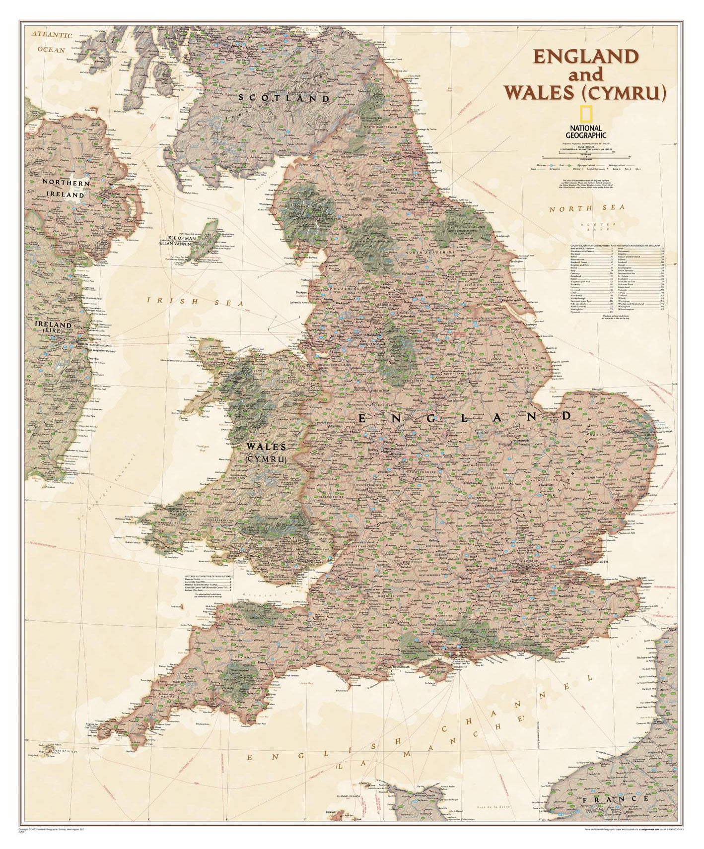
England & Wales Executive Antique Style National Geographic 762 x 914mm Wall Map
$69.95
or make 4 interest-free payments of
$17.49 AUD
fortnightly with
![]() More info
More info
🏰 England & Wales Executive Antique-Style Wall Map
By National Geographic | 762 × 914 mm | 🌍 Edition: Executive Style
Step into the rich tapestry of England and Wales (Cymru) with this magnificent antique-style wall map from National Geographic. Featuring exquisite detail and timeless cartographic elegance, this is far more than just a map—it’s a celebration of heritage, geography, and the enduring beauty of two of Britain’s most storied nations.
Crafted in National Geographic’s renowned Executive style, this map blends a classic antique colour palette with shaded relief and a finely detailed background grid, echoing the precision and artistry for which the Society is famed. Whether you're tracing the winding coastline of Pembrokeshire, locating historic cities like York or Bath, or appreciating the beauty of Snowdonia and the Lake District, this map offers both grandeur and geographic clarity in one remarkable presentation.
🌟 Features at a Glance
-
🗺️ Stunning Antique Style Design
Warm, earthy tones and classic cartographic textures that pair beautifully with traditional or professional décor. -
🏞️ Exceptional Geographic Detail
Includes thousands of place names, transportation networks, administrative boundaries, and topographical shading for terrain comprehension. -
🏰 Comprehensive Cultural Coverage
Highlights National Parks, UNESCO sites, cathedrals, historic locations, canals, railways, and even oil pipelines—telling the story of England and Wales both past and present. -
🧭 Multilingual & Cross-Border Context
Features Welsh (Cymraeg) and Manx place names, with map coverage extending into Scotland, Northern Ireland, Ireland, and even a portion of northern France for contextual geographic awareness.
🖼️ Display & Material Options
| Format | Material | Perfect For |
|---|---|---|
| Paper | Heavyweight 160 gsm matte-coated stock | Ideal for framing under glass |
| Laminated | Gloss encapsulated (2 × 80-micron layers) | Durable, wipe-clean surface for classrooms or offices |
| Laminated with Timber Rails | Laminated + natural timber hangers | Classic display ready to hang – no frame needed |
| Canvas | 395 gsm HP Matte Canvas + pigment inks | Textured, luxurious, fade-resistant |
| Canvas with Timber Rails | Canvas + natural timber hangers & cord | Elegant gallery-style hanging solution |
All formats are printed using archival pigment-based inks to ensure stunning clarity and long-lasting colour fidelity.
📌 Specifications
| Specification | Details |
|---|---|
| Title | England & Wales Executive Antique Wall Map |
| Publisher | National Geographic |
| Style | Executive (Antique palette) |
| Languages | English, Welsh (Cymraeg), Manx |
| Content | England, Wales, partial Ireland, Scotland, France |
| Highlights | Roads, railways, cities, pipelines, canals, airports, parks, historic sites |
| Size | 762 mm (width) × 914 mm (height) |
| Printed In | Australia |
| Edition | National Geographic Executive Series |
🕰️ Please allow up to 10 working days for delivery of hang-railed maps as these are hand-assembled by our professional framer.
🎁 Perfect For:
-
History buffs and genealogy enthusiasts researching British roots
-
Offices, libraries, or study rooms with a classic aesthetic
-
Schools or institutions teaching geography, politics, or heritage
-
Gifts for travellers, expats, or lovers of the British Isles
Bring the timeless story of England and Wales into your space—crafted with the beauty, authority, and elegance that only National Geographic can deliver.
Frequently Asked Questions
What are the dimensions of the England & Wales Executive Antique Style National Geographic 762 x 914m?
Mapworld wall maps range from standard 700×1000mm to large-format 1000×1430mm Supermaps. The exact dimensions for this map are shown in the product title. Where multiple sizes are available, select your preferred size when adding to cart.
Is this wall map available laminated?
Many Mapworld wall maps are available in paper, laminated, or framed finishes. Check the product options when adding to cart. Laminated maps are wipe-clean and more durable.
Is this the latest edition?
Mapworld stocks the most current editions available from all publishers. Edition year is shown in the product title where applicable. Mapworld updates its catalogue as new editions are released.
Can I write on or pin this wall map?
Laminated wall maps can be written on with whiteboard markers and wiped clean. Paper maps can be pinned on a corkboard. Choose a laminated option for a writeable surface.
Does Mapworld ship the England & Wales Executive Antique Style National Geographic 762 x 914m across Australia?
Yes, Mapworld ships Australia-wide. Standard shipping is a flat $7 rate, with free standard shipping on orders over $75. Express options are available at checkout. Most orders placed before 2pm AEST on weekdays are dispatched same day.
Related Items


© 2026 Mapworld. Website designed by Genie Media
X