- Australia ▾
- Topographic
▾
- Australia AUSTopo 250k (2025)
- Australia 50k Geoscience maps
- Australia 100k Geoscience maps
- Australia 250k Geoscience maps
- Australia 1:1m Geoscience maps
- New Zealand 50k maps
- New Zealand 250k maps
- New South Wales 25k maps
- New South Wales 50k maps
- New South Wales 100k maps
- Queensland 10k maps
- Queensland 25k maps
- Queensland 50k maps
- Queensland 100k maps
- Western Australia 25k maps
- Western Australia 50k maps
- Western Australia 100k maps
- Compasses
- Software
- GPS Systems
- International ▾
- Wall Maps
▾
- World
- Australia & New Zealand
- Countries, Continents & Regions
- Historical
- Vintage National Geographic
- Australian Capital Territory
- New South Wales
- Northern Territory
- Queensland
- South Australia
- Tasmania
- Victoria
- Western Australia
- Celestial
- Children's
- Mining & Resources
- Wine Maps
- Healthcare
- Postcode Maps
- Electoral Maps
- Nautical ▾
- Flags
▾
- Australian Flag Sets & Banners
- Flag Bunting
- Handwavers
- Australian National Flags
- Aboriginal Flags
- Torres Strait Islander Flags
- International Flags
- Flagpoles & Accessories
- Australian Capital Territory Flags
- New South Wales Flags
- Northern Territory Flags
- Queensland Flags
- South Australia Flags
- Tasmania Flags
- Victoria Flags
- Western Australia Flags
- Gifts ▾
- Globes ▾
Dear valued customer. Please note that our checkout is not supported by old browsers. Please use a recent browser to access all checkout capabilities


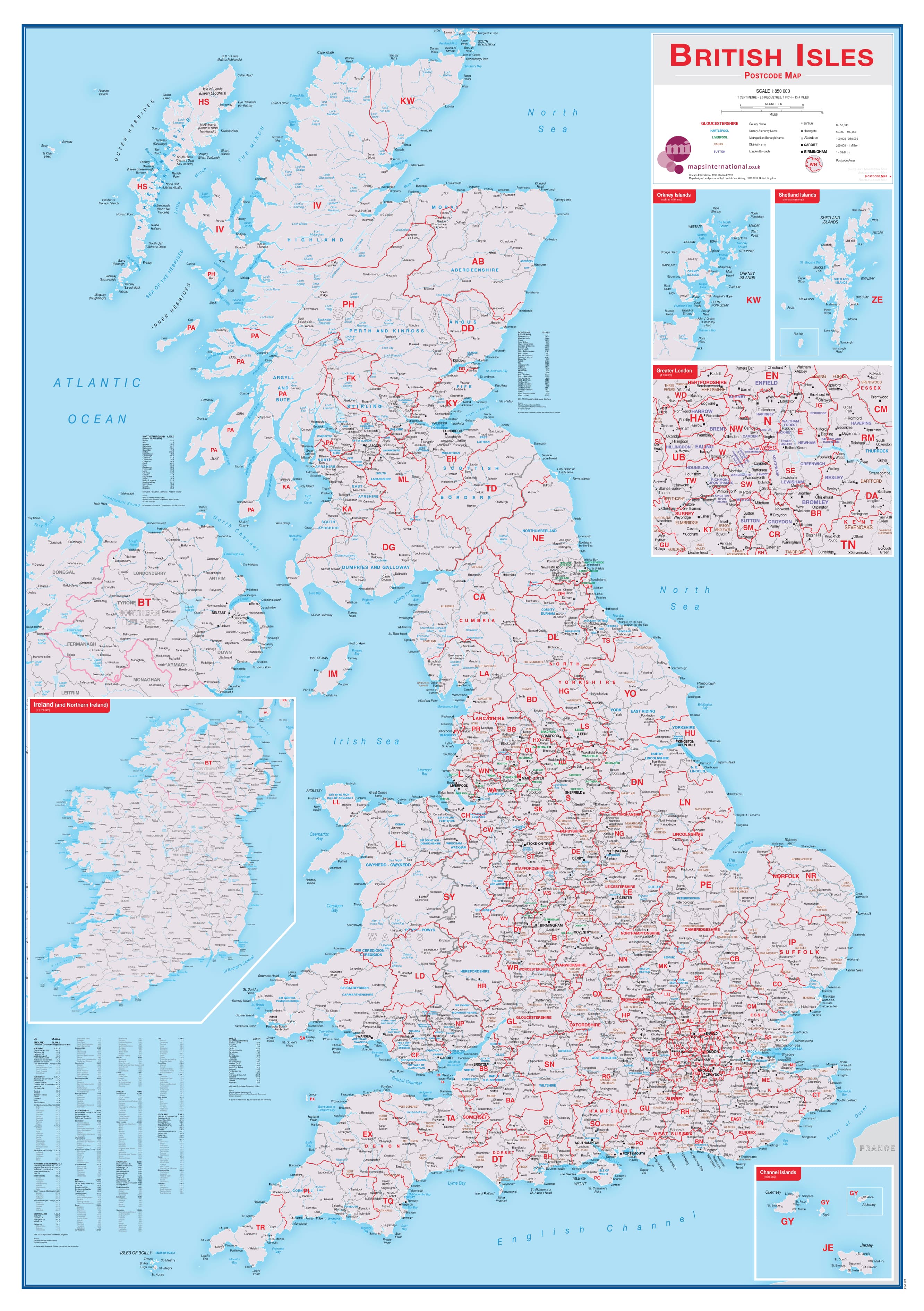
British Isles Postcode Maps International 841 x 1189mm Wall Map
$79.95
or make 4 interest-free payments of
$19.99 AUD
fortnightly with
![]() More info
More info
📮 British Isles Postcode Wall Map
By Maps International | 841 x 1189 mm | Scale 1:850,000
A practical and beautifully designed postcode reference map for business, planning, and everyday use.
Whether you're managing logistics, planning a delivery route, analysing regional sales data, or simply want a clear and attractive overview of the UK and Ireland’s postal structure, this British Isles Postcode Map by Maps International is the ideal tool.
Clearly showing all postcode areas across England, Scotland, Wales, Northern Ireland, and the Republic of Ireland, this large-format wall map is both informative and easy to use. With boroughs, districts, counties and cities all labelled, and postcode boundaries crisply defined, this is a map that means business—yet it's designed with enough visual appeal to suit home offices and corporate boardrooms alike.
The map also includes a detailed enlargement of Greater London, clearly breaking out its complex network of postcode districts so you can pinpoint every zone at a glance—from NW to SE, from EC to W.
🧭 Key Features & Benefits
-
✉️ Full Coverage of British Isles Postcode Areas — Each postcode zone (e.g. SW, CV, B, NW, etc.) is distinctly coloured and labelled
-
🏙️ Borough, County & District Names — All administrative divisions are shown for context
-
📈 City Locations with Population Indicators — Major cities marked and sized by population
-
🗺️ Expanded Greater London Area — Inset map zooms in to show the capital’s postcode complexity in greater detail
-
🛠️ Ideal for Business & Office Use — A practical reference tool for logistics, service areas, sales planning, or office wall display
🎯 Who Is This Map For?
This map is perfectly suited to:
-
📦 Delivery & Logistics Teams — Plan routes and coverage zones with confidence
-
🧮 Sales & Marketing Departments — Align campaigns and targets with geographic boundaries
-
🏢 Corporate Offices & Call Centres — Keep a postcode reference visible and accessible
-
🏡 Small Businesses & Home Offices — Plan smarter and serve customers better
-
📚 Students & Analysts — Use it for geographic research, data plotting, or visual learning
🖨️ Format & Finishing Options
Choose the right finish for your environment:
| Format | Material | Description |
|---|---|---|
| Paper | Heavyweight 160 gsm Matte Coated Paper | Perfect for framing under glass |
| Laminated | 80-micron Gloss Encapsulation | Durable, tear-resistant, and wipeable |
| Canvas | 395 gsm HP Matte Canvas | Premium feel with archival-quality pigment inks |
| Canvas with Timber Hang Rails | As above, plus wooden rails | Ready to hang, natural timber finish |
| Laminated with Timber Hang Rails | Laminated and framed | Tough and stylish for immediate display |
All versions are printed using fade-resistant pigment-based inks for brilliant colour and longevity.
📐 Specifications
| Feature | Detail |
|---|---|
| Map Title | British Isles Postcode Map |
| Publisher | Maps International |
| Scale | 1:850,000 |
| Size | 841 mm (wide) x 1189 mm (high) – A0 portrait |
| Published | 2017 |
| Format Options | Paper, Laminated, Canvas, Laminated with Rails, Canvas with Rails |
| Made in | Australia |
🧵 Hanging Made Easy
Opt for canvas or laminated versions with timber hang rails for a professional and elegant finish. Handcrafted in Australia, the rails are finished in a natural lacquered timber and include a hanging cord attached to the top rail.
🕰️ Please allow up to 10 working days for delivery of hang-railed maps, as each one is individually assembled by our expert framer.
✨ Why Choose This Map?
This is more than a functional postcode guide—it's a statement piece for your workspace. Clear, clean, and easy to read from a distance, this map makes essential postcode data instantly accessible while elevating the look of any room. Whether you're plotting growth, answering service calls, or making real-time decisions, this map keeps you oriented and empowered.
🛒 Add this professional British Isles Postcode Map to your workspace today and transform the way you plan, work, and visualise the regions you serve.
Frequently Asked Questions
What are the dimensions of the British Isles Postcode Maps International 841 x 1189mm Wall Map?
Mapworld wall maps range from standard 700×1000mm to large-format 1000×1430mm Supermaps. The exact dimensions for this map are shown in the product title. Where multiple sizes are available, select your preferred size when adding to cart.
Is this wall map available laminated?
Many Mapworld wall maps are available in paper, laminated, or framed finishes. Check the product options when adding to cart. Laminated maps are wipe-clean and more durable.
Is this the latest edition?
Mapworld stocks the most current editions available from all publishers. Edition year is shown in the product title where applicable. Mapworld updates its catalogue as new editions are released.
Can I write on or pin this wall map?
Laminated wall maps can be written on with whiteboard markers and wiped clean. Paper maps can be pinned on a corkboard. Choose a laminated option for a writeable surface.
Does Mapworld ship the British Isles Postcode Maps International 841 x 1189mm Wall Map across Australia?
Yes, Mapworld ships Australia-wide. Standard shipping is a flat $7 rate, with free standard shipping on orders over $75. Express options are available at checkout. Most orders placed before 2pm AEST on weekdays are dispatched same day.
Related Items


© 2026 Mapworld. Website designed by Genie Media
X