- Australia ▾
- Topographic
▾
- Australia AUSTopo 250k (2024)
- Australia 50k Geoscience maps
- Australia 100k Geoscience maps
- Australia 250k Geoscience maps
- Australia 1.1m Geoscience maps
- New Zealand 50k maps
- New Zealand 250k maps
- New South Wales 25k maps
- New South Wales 50k maps
- New South Wales 100k maps
- Queensland 10k maps
- Queensland 25k maps
- Queensland 50k maps
- Queensland 100k maps
- Compasses
- Software
- GPS Systems
- Orienteering
- International ▾
- Wall Maps
▾
- World
- Australia & New Zealand
- Countries, Continents & Regions
- Historical
- Vintage National Geographic
- Australian Capital Territory
- New South Wales
- Northern Territory
- Queensland
- South Australia
- Tasmania
- Victoria
- Western Australia
- Celestial
- Children's
- Mining & Resources
- Wine Maps
- Healthcare
- Postcode Maps
- Electoral Maps
- Nautical ▾
- Flags
▾
- Australian Flag Sets & Banners
- Flag Bunting
- Handwavers
- Australian National Flags
- Aboriginal Flags
- Torres Strait Islander Flags
- International Flags
- Flagpoles & Accessories
- Australian Capital Territory Flags
- New South Wales Flags
- Northern Territory Flags
- Queensland Flags
- South Australia Flags
- Tasmania Flags
- Victoria Flags
- Western Australia Flags
- Gifts ▾
- Globes ▾
Dear valued customer. Please note that our checkout is not supported by old browsers. Please use a recent browser to access all checkout capabilities


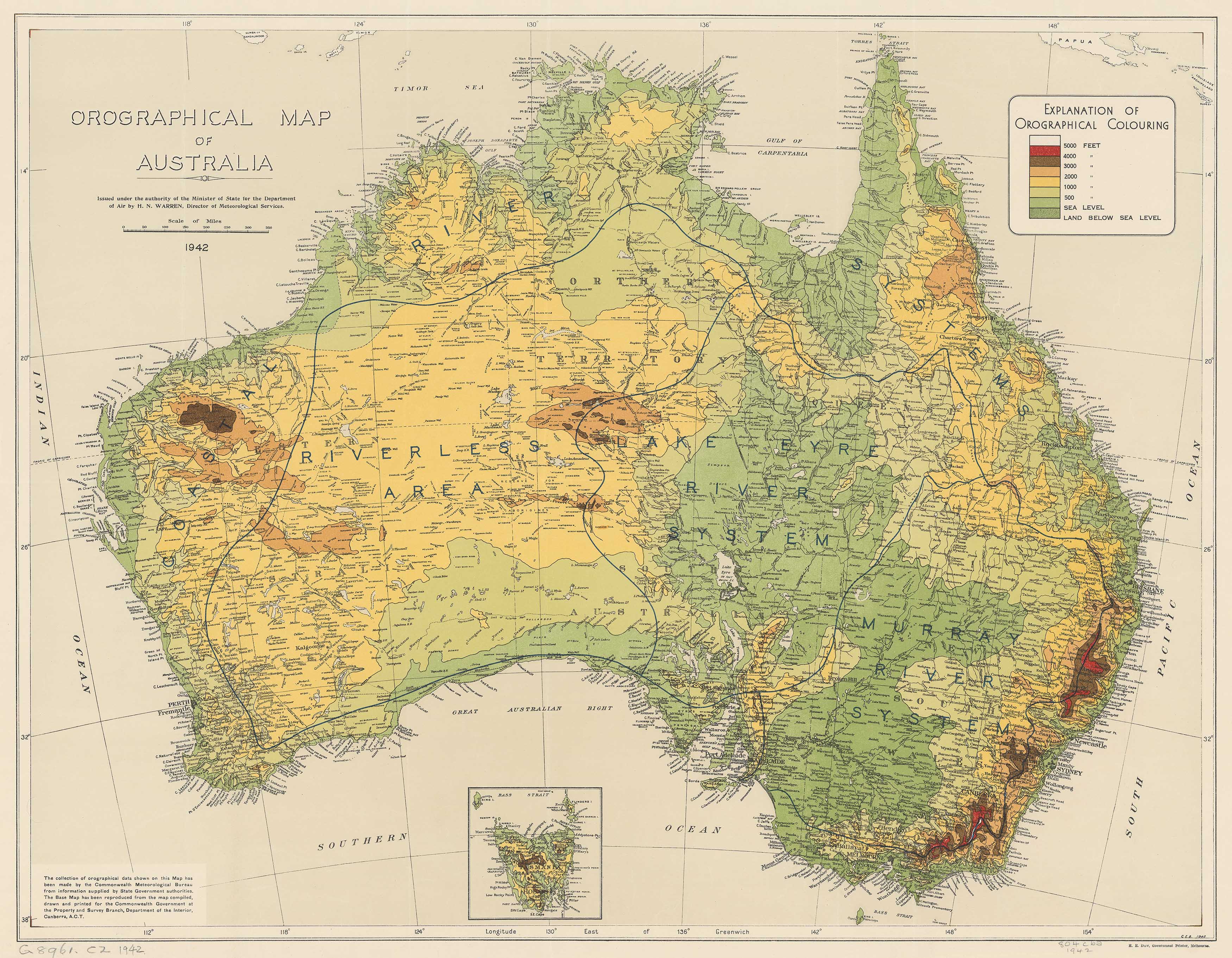
Vintage Topographic Map of Australia 1942
$59.95
or make 4 interest-free payments of
$14.99 AUD
fortnightly with
![]() More info
More info
A rare wartime depiction of Australia's elevation and landforms, commissioned for flight planning during WWII.
This striking Orographical Map of Australia, originally published in 1942 by the Department of Air, presents a beautifully detailed topographic rendering of the Australian continent, highlighting its elevation profile in subtle gradients. Designed during the height of World War II, this map likely served aviation planning and military logistics, offering a unique glimpse into how Australia’s terrain was studied and understood at the time.
The map shows height contours from sea level up to 5,000 feet, using a colour-coded system to distinguish varying altitudes. Ranges, plateaus, and lowlands are clearly indicated, and the overall style reflects the mid-century cartographic aesthetic—precise, utilitarian, and quietly elegant.
Whether you're a history enthusiast, map collector, or admirer of vintage design, this piece offers both visual appeal and historical value.
Key Features:
-
Original Publication: Department of Air, Australia, 1942
-
Purpose: Commissioned during WWII to assist in aviation route planning
-
Map Focus: Orography (land elevation) across Australia, including mountain ranges, basins, and plains
-
Elevation Markings: Colour-coded height bands from sea level to 5,000 feet
-
Cartographic Style: Classic mid-century topographic representation
Available Finishes & Display Options:
| Finish | Description |
|---|---|
| Paper (160gsm) | Archival-grade, ideal for framing under glass—preserves the vintage look. |
| Laminated | Encapsulated in 80-micron gloss laminate—durable, wipeable, and perfect for educational or high-traffic environments. |
| Canvas (395gsm HP Professional Matte) | Printed using pigment-based inks for fade resistance and sharp detail. A beautiful and durable finish that enhances the vintage aesthetic. |
Optional Hanging
For a timeless and practical display, add wooden hang rails—lacquered in natural timber, with a cord attached to the top roller. Simply hang from a single wall hook for instant impact.
Note: Please allow up to 10 working days for maps ordered with hang rails, as they are fitted by our framer.
Available Sizes:
| Format | Dimensions |
|---|---|
| Standard | 800 mm (W) x 620 mm (H) |
| Large | 1150 mm (W) x 890 mm (H) |
A Vintage Map with Wartime Roots
This map is far more than a topographic reference—it’s a rare relic from Australia’s wartime cartographic archives. Its purpose was practical, but the result is unexpectedly beautiful: delicate shading, precise typography, and a depiction of Australia that speaks to a pivotal moment in global history. Ideal for display in studies, libraries, aviation lounges, or heritage spaces, it adds historical gravitas and understated elegance to any room.