- Australia ▾
- Topographic
▾
- Australia AUSTopo 250k (2025)
- Australia 50k Geoscience maps
- Australia 100k Geoscience maps
- Australia 250k Geoscience maps
- Australia 1:1m Geoscience maps
- New Zealand 50k maps
- New Zealand 250k maps
- New South Wales 25k maps
- New South Wales 50k maps
- New South Wales 100k maps
- Queensland 10k maps
- Queensland 25k maps
- Queensland 50k maps
- Queensland 100k maps
- Western Australia 25k maps
- Western Australia 50k maps
- Western Australia 100k maps
- Compasses
- Software
- GPS Systems
- International ▾
- Wall Maps
▾
- World
- Australia & New Zealand
- Countries, Continents & Regions
- Historical
- Vintage National Geographic
- Australian Capital Territory
- New South Wales
- Northern Territory
- Queensland
- South Australia
- Tasmania
- Victoria
- Western Australia
- Celestial
- Children's
- Mining & Resources
- Wine Maps
- Healthcare
- Postcode Maps
- Electoral Maps
- Nautical ▾
- Flags
▾
- Australian Flag Sets & Banners
- Flag Bunting
- Handwavers
- Australian National Flags
- Aboriginal Flags
- Torres Strait Islander Flags
- International Flags
- Flagpoles & Accessories
- Australian Capital Territory Flags
- New South Wales Flags
- Northern Territory Flags
- Queensland Flags
- South Australia Flags
- Tasmania Flags
- Victoria Flags
- Western Australia Flags
- Gifts ▾
- Globes ▾
Dear valued customer. Please note that our checkout is not supported by old browsers. Please use a recent browser to access all checkout capabilities


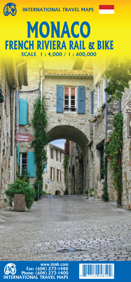
Monaco & French Riviera Rail & Bike ITMB Map
$24.95
Afterpay is only available for orders between $50.00 and $1000.00 More info
🇲🇨 Monaco & French Riviera Rail & Bike Travel Map – ITMB Publishing
Double-sided Folded Map | Monaco + Southern France | EuroVelo Routes | Size: 690 mm x 990 mm (27" x 39")
🌍 Explore the Jewel of the Riviera – From Monaco’s Glitz to Provence’s Charm
Experience the elegance, coastal beauty, and historic richness of Southern France and Monaco with this beautifully detailed Monaco & French Riviera Rail & Bike Map by ITMB. Designed for cyclists, train travellers, and cultural explorers alike, this double-sided travel map combines an ultra-detailed map of the Principality of Monaco with a sweeping view of the French Riviera—stretching from the Italian border to the Spanish frontier, and inland through Provence, Languedoc, and the Côte d’Azur.
🧭 Whether you're pedalling along a EuroVelo route, navigating scenic rail lines, or discovering medieval cities and beachside resorts, this is the essential guide to one of Europe’s most captivating coastal regions.
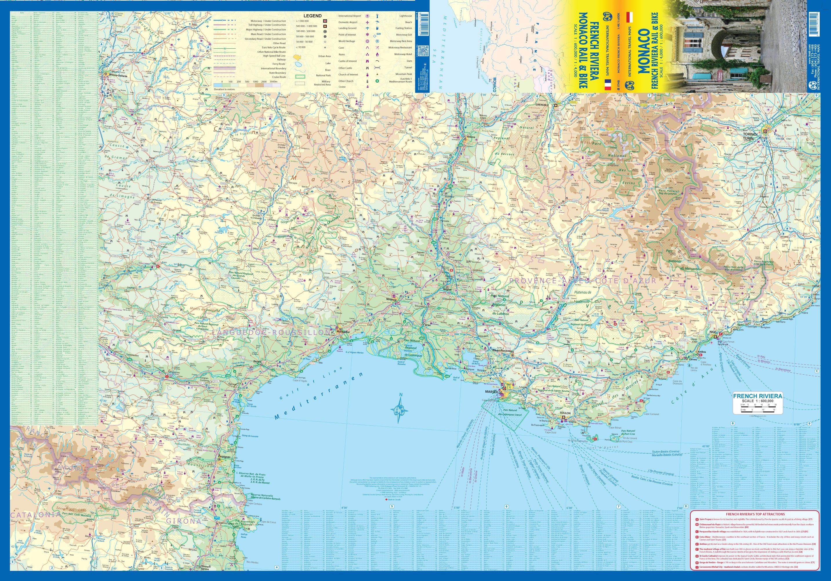
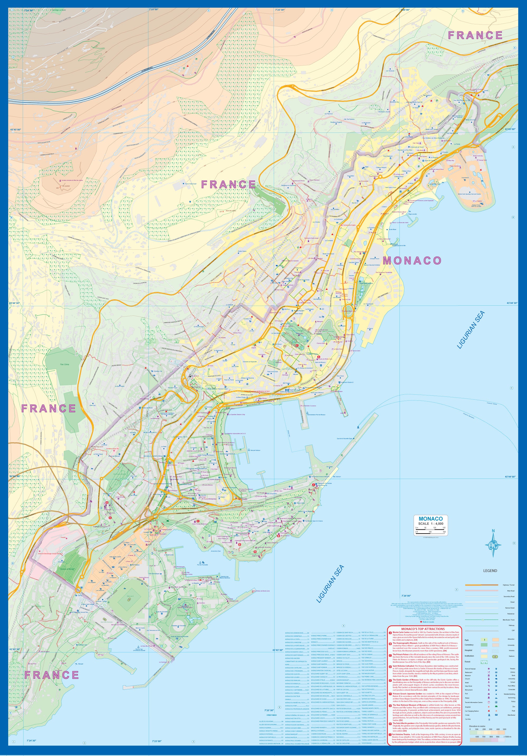
🗺️ Map Features & Coverage
| 📍 Side A – Monaco (City-State Focus) | 📍 Side B – French Riviera & Inland Regions |
|---|---|
| Ultra-detailed map of Monaco at city scale | Regional map from the Italian border to Spain |
| Key landmarks: Monte Carlo, harbour, casino, palace | Covers Nice, Cannes, Avignon, Nîmes, Grenoble, more |
| Top attractions list and walking routes | Includes Provence, Côte d’Azur, Languedoc |
| City streets, marina, rail station, and terrain detail | Rail lines and EuroVelo bike routes clearly marked |
🚴♂️🚆 Designed for Travellers by Train, Bike, or Foot
-
🚴 EuroVelo cycling routes shown across the Riviera
-
🚆 Rail networks and scenic train routes for efficient planning
-
🏛️ Castles, palaces, and historical sites prominently noted
-
🗺️ Designed for bikers, cruisers, and cultural adventurers
-
📏 Folded for convenience, unfolds to 690 mm x 990 mm (27” x 39”)
📌 This is one of the only maps to offer a dedicated, fully detailed rendering of Monaco, making it a must-have for collectors and visitors alike.
🧳 Perfect For
| 👤 Who It’s For | 🚀 Why It’s Useful |
|---|---|
| Cyclists & EuroVelo travellers | Plan routes and rest stops with clarity |
| Train travellers & rail pass users | Navigate connections from Monaco to Provence and beyond |
| Cruise passengers visiting the Riviera | Understand ports, cities, and cultural highlights |
| Independent travellers & history lovers | Explore castles, walled towns, and UNESCO sites |
| Map collectors & Monaco fans | Rare standalone map of Monaco with detailed coverage |
🛡️ Optional Lamination Available
Enhance your travel experience with a laminated version, professionally encapsulated using 80-micron gloss laminate:
-
💧 Water-resistant and wipeable – great for outdoor use and bike bags
-
✍️ Use with whiteboard markers for reusable route planning
-
🛡️ Durable against folds, tears, and repeated handling
Note: Laminated maps are produced from the folded version; original fold lines may be faintly visible but do not detract from clarity.
📦 Product Summary
| 📌 Specification | 📍 Details |
|---|---|
| Title | Monaco & French Riviera Rail & Bike Map |
| Publisher | ITMB Publishing (Canada) |
| Format | Double-sided, folded map |
| Coverage | Monaco, French Riviera, Provence, Languedoc |
| Map Size (unfolded) | 690 mm x 990 mm (27” x 39”) |
| ISBN | 9781771296521 |
| Language | English |
| Laminated Version | Optional gloss encapsulation |
🛒 Plan Your Perfect Mediterranean Escape
From Monaco’s glittering harbours to the lavender-scented hills of Provence, this beautifully crafted map helps you navigate Southern France in unforgettable detail. Ideal for cyclists, walkers, rail travellers, or cultural explorers, the Monaco & French Riviera Rail & Bike Map by ITMB is the ultimate companion for an adventure-rich journey along Europe’s sun-soaked coast.
Add to cart today and begin planning your elegant escape through one of Europe’s most storied and scenic regions.
Frequently Asked Questions
Where can I buy the Monaco & French Riviera Rail & Bike ITMB Map?
The Monaco & French Riviera Rail & Bike ITMB Map is available to buy online from Mapworld, Australia's largest map and geographic product retailer, with fast shipping Australia-wide.
Is the Monaco & French Riviera Rail & Bike ITMB Map in stock at Mapworld?
Mapworld maintains extensive stock across its map range and aims for fast dispatch. Orders placed before 2pm AEST on business days are typically dispatched the same day, with standard and express Australia-wide delivery options available.
What is Mapworld's returns policy?
Mapworld accepts returns on undamaged items in original condition. Contact Mapworld within 90 days of purchase to arrange a return or exchange.
Does Mapworld ship the Monaco & French Riviera Rail & Bike ITMB Map across Australia?
Yes, Mapworld ships Australia-wide. Standard shipping is a flat $7 rate, with free standard shipping on orders over $75. Express options are available at checkout. Most orders placed before 2pm AEST on weekdays are dispatched same day.
Related Items


© 2026 Mapworld. Website designed by Genie Media
X