- Australia ▾
- Topographic
▾
- Australia AUSTopo 250k (2025)
- Australia 50k Geoscience maps
- Australia 100k Geoscience maps
- Australia 250k Geoscience maps
- Australia 1:1m Geoscience maps
- New Zealand 50k maps
- New Zealand 250k maps
- New South Wales 25k maps
- New South Wales 50k maps
- New South Wales 100k maps
- Queensland 10k maps
- Queensland 25k maps
- Queensland 50k maps
- Queensland 100k maps
- Western Australia 25k maps
- Western Australia 50k maps
- Western Australia 100k maps
- Compasses
- Software
- GPS Systems
- International ▾
- Wall Maps
▾
- World
- Australia & New Zealand
- Countries, Continents & Regions
- Historical
- Vintage National Geographic
- Australian Capital Territory
- New South Wales
- Northern Territory
- Queensland
- South Australia
- Tasmania
- Victoria
- Western Australia
- Celestial
- Children's
- Mining & Resources
- Wine Maps
- Healthcare
- Postcode Maps
- Electoral Maps
- Nautical ▾
- Flags
▾
- Australian Flag Sets & Banners
- Flag Bunting
- Handwavers
- Australian National Flags
- Aboriginal Flags
- Torres Strait Islander Flags
- International Flags
- Flagpoles & Accessories
- Australian Capital Territory Flags
- New South Wales Flags
- Northern Territory Flags
- Queensland Flags
- South Australia Flags
- Tasmania Flags
- Victoria Flags
- Western Australia Flags
- Gifts ▾
- Globes ▾
Dear valued customer. Please note that our checkout is not supported by old browsers. Please use a recent browser to access all checkout capabilities


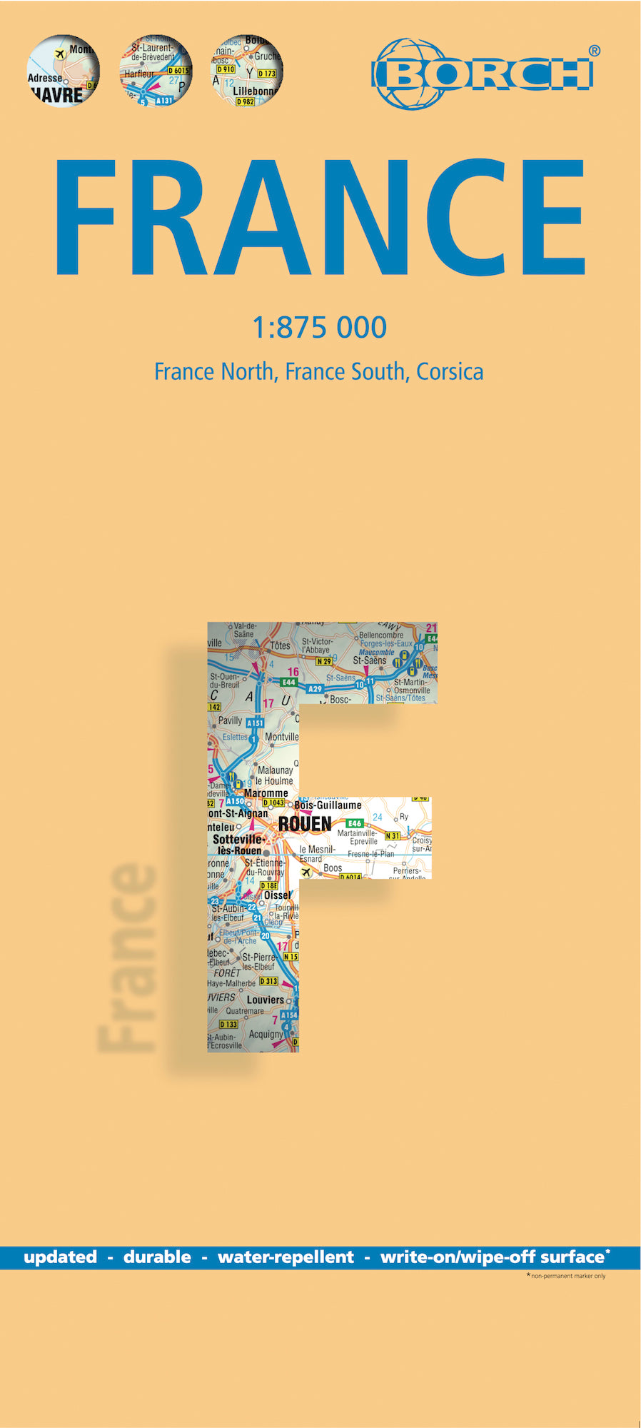


France Borch Folded Laminated Map
$21.95
Afterpay is only available for orders between $50.00 and $1000.00 More info
🇫🇷 France Borch Folded Laminated Map
Soft-Laminated Road Map | 9th Edition | Double-Sided | Includes Corsica & Administrative Insets
🗺️ Overview
Explore the full breadth of France with this beautifully detailed, soft-laminated, folded road map from Borch – now in its 9th edition. Designed for ease of use, durability, and clarity, this weatherproof and wipeable map is perfect for road trips, planning itineraries, and educational reference. Covering northern and southern France at a scale of 1:875,000, along with Corsica and an administrative overview, it’s a highly practical tool for both travellers and map enthusiasts.
📌 Map Details
-
🧭 Scale: 1:875,000 (approx. 13.8 km = 1 cm)
-
📐 Map Size (Unfolded): 990 mm x 685 mm (39 in. x 27 in.)
-
📦 Folded Size: 243 mm x 110 mm x 10 mm (9.6 in. x 4.3 in. x 0.4 in.)
-
📚 Edition: 9th Edition, 2014
-
📘 ISBN: 978-3-86609-348-5
-
⚖️ Weight: 101 g (3.6 oz)
-
💧 Format: Laminated, waterproof, wipeable surface
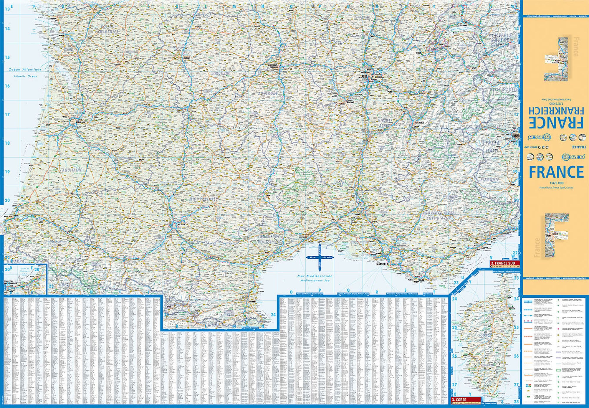
🗺️ Included Maps & Insets
| Map | Scale |
|---|---|
| France North | 1:875,000 |
| France South | 1:875,000 |
| Corsica (Corse) | 1:875,000 |
| France Administrative Divisions | N/A |
| Europe Time Zones | N/A |
🔍 Features & Highlights
-
✅ Durable laminated surface – Water-repellent and tear-resistant
-
✅ Folds flat & easy to carry – Ideal for on-the-go use
-
✅ Public transport, museums, markets, and top sights clearly marked
-
✅ Climate charts – Including temperatures, rainfall, humidity & sunshine hours
-
✅ Useful conversions – Metric/imperial units, temperature, and weights
-
✅ Overview maps and time zones included
-
✅ Index of place names for quick navigation
🌍 About France
From the snow-capped Alps to the lavender fields of Provence, France is a country of diverse landscapes and deep cultural heritage. Bordered by Belgium, Germany, Switzerland, Italy, Spain, and surrounded by the Atlantic, Mediterranean, and English Channel, France is the most visited country in the world, welcoming over 80 million visitors annually. Highlights include:
-
🗼 Paris – Home to the Eiffel Tower, Louvre, and Notre-Dame
-
🏖️ French Riviera – Glamorous coastal towns like Nice and Cannes
-
🍷 Bordeaux & Burgundy – World-famous wine regions
-
🏰 Loire Valley – Stunning Renaissance châteaux
-
🏔️ Alps & Pyrenees – Ideal for hiking, skiing, and nature escapes
-
🧀 Culinary capital of Europe – From croissants to coq au vin
Whether you're driving the winding roads of Alsace, navigating city streets in Lyon, or planning a ferry to Corsica, this map is your reliable companion.
🎯 Who This Map Is For
-
🚗 Self-drive holidaymakers exploring France by car
-
🥾 Walkers & cyclists planning scenic routes
-
🎓 Students & educators seeking an accurate visual aid
-
🧳 Travellers wanting a compact and comprehensive map
-
🗃️ Collectors & cartophiles seeking a premium laminated reference
📦 Shipping & Availability
-
✅ Ships from Australia
-
📮 Fast dispatch – next business day
-
🗓️ Please allow additional time if ordering with other print-on-demand maps
🏆 Why Choose Borch Maps?
Borch laminated maps are internationally trusted for their:
-
🧼 Wipe-clean surfaces
-
💧 Waterproof, rip-resistant durability
-
🗺️ Crisp cartographic clarity
-
✈️ Perfect travel format — light, portable, and easy to fold
France Borch Laminated Map
A smart, durable map for France in all its regions – practical, portable, and designed for those who value clarity on the road.
Frequently Asked Questions
Where can I buy the France Borch Folded Laminated Map?
The France Borch Folded Laminated Map is available to buy online from Mapworld, Australia's largest map and geographic product retailer, with fast shipping Australia-wide.
Is the France Borch Folded Laminated Map in stock at Mapworld?
Mapworld maintains extensive stock across its map range and aims for fast dispatch. Orders placed before 2pm AEST on business days are typically dispatched the same day, with standard and express Australia-wide delivery options available.
What is Mapworld's returns policy?
Mapworld accepts returns on undamaged items in original condition. Contact Mapworld within 90 days of purchase to arrange a return or exchange.
Does Mapworld ship the France Borch Folded Laminated Map across Australia?
Yes, Mapworld ships Australia-wide. Standard shipping is a flat $7 rate, with free standard shipping on orders over $75. Express options are available at checkout. Most orders placed before 2pm AEST on weekdays are dispatched same day.
Related Items


© 2026 Mapworld. Website designed by Genie Media
X