- Australia ▾
- Topographic
▾
- Australia AUSTopo 250k (2025)
- Australia 50k Geoscience maps
- Australia 100k Geoscience maps
- Australia 250k Geoscience maps
- Australia 1:1m Geoscience maps
- New Zealand 50k maps
- New Zealand 250k maps
- New South Wales 25k maps
- New South Wales 50k maps
- New South Wales 100k maps
- Queensland 10k maps
- Queensland 25k maps
- Queensland 50k maps
- Queensland 100k maps
- Western Australia 25k maps
- Western Australia 50k maps
- Western Australia 100k maps
- Compasses
- Software
- GPS Systems
- International ▾
- Wall Maps
▾
- World
- Australia & New Zealand
- Countries, Continents & Regions
- Historical
- Vintage National Geographic
- Australian Capital Territory
- New South Wales
- Northern Territory
- Queensland
- South Australia
- Tasmania
- Victoria
- Western Australia
- Celestial
- Children's
- Mining & Resources
- Wine Maps
- Healthcare
- Postcode Maps
- Electoral Maps
- Nautical ▾
- Flags
▾
- Australian Flag Sets & Banners
- Flag Bunting
- Handwavers
- Australian National Flags
- Aboriginal Flags
- Torres Strait Islander Flags
- International Flags
- Flagpoles & Accessories
- Australian Capital Territory Flags
- New South Wales Flags
- Northern Territory Flags
- Queensland Flags
- South Australia Flags
- Tasmania Flags
- Victoria Flags
- Western Australia Flags
- Gifts ▾
- Globes ▾
Dear valued customer. Please note that our checkout is not supported by old browsers. Please use a recent browser to access all checkout capabilities


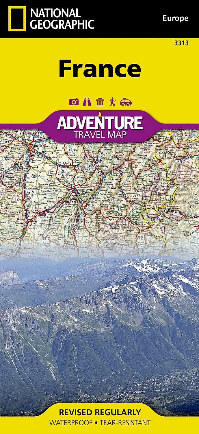
France National Geographic Folded Map
$27.95
Afterpay is only available for orders between $50.00 and $1000.00 More info
🇫🇷 France Adventure Map – National Geographic
Waterproof • Tear-Resistant • Travel-Ready
Unfolded Size: 965 mm x 660 mm
Folded Size: 235 mm x 108 mm
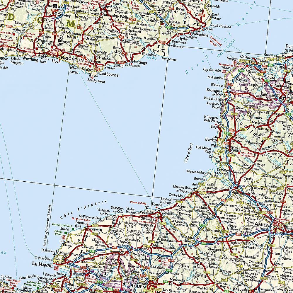
Explore France in vivid detail with National Geographic’s beautifully designed France Adventure Map—a trusted companion for adventurous travellers, cultural explorers, and road trippers alike. Crafted with the needs of real-world explorers in mind, this double-sided map offers a comprehensive, accurate, and durable guide to one of Europe’s most beloved destinations.
🧭 Key Features:
-
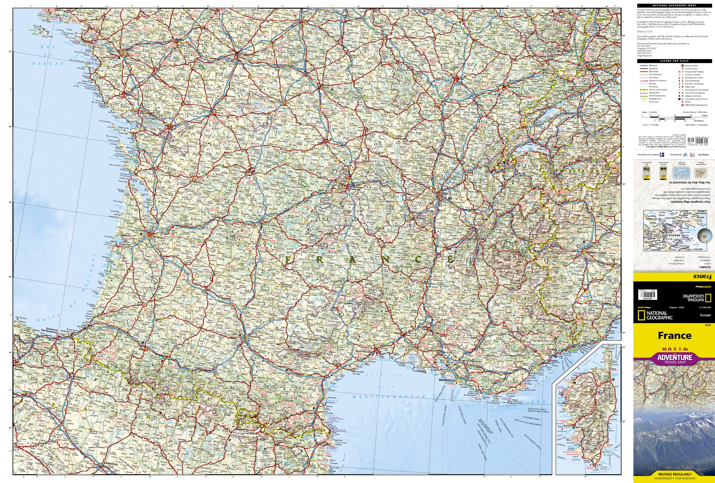
Double-Sided Coverage:
-
Front Side – Southern France, from the Italian and Swiss borders to the Bay of Biscay and the Mediterranean, including Corsica, Monaco, Andorra, and northern Spain.
-
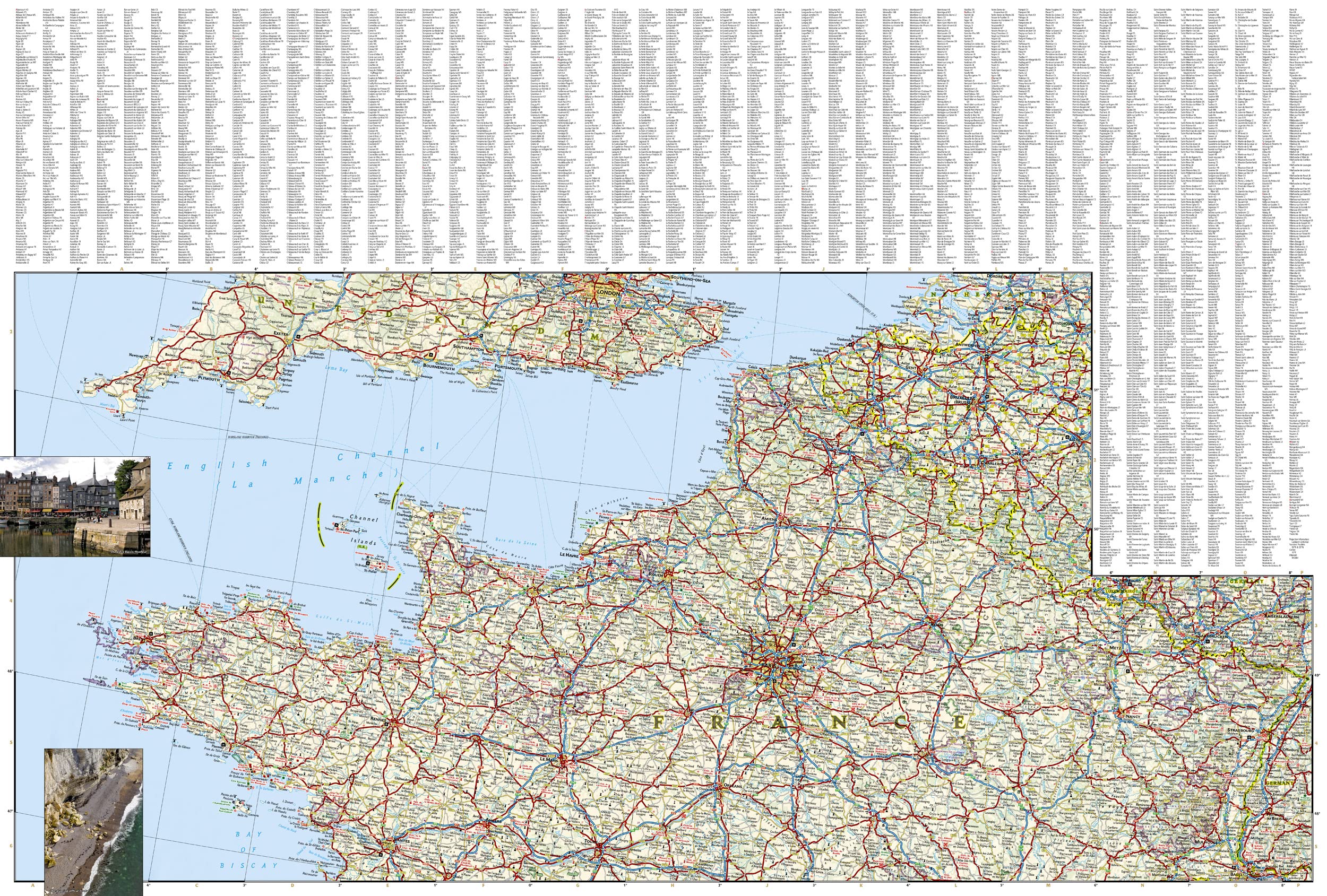
Reverse Side – Northern France, including Paris, Normandy, the Loire Valley, Champagne, and borders with Belgium, Luxembourg, and Germany.
-
-
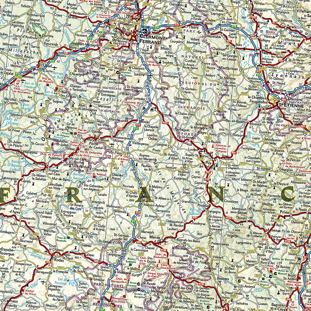
Clearly Marked Road Networks:
-
Motorways, highways, national and regional roads
-
Tracks, scenic routes, and lesser-travelled byways
-
Ferry routes and key transit corridors
-
-
Hundreds of Points of Interest:
-
UNESCO World Heritage sites
-
Castles, cathedrals, abbeys, and vineyards
-
National parks, coastal attractions, and scenic overlooks
-
Historical monuments and battlefields
-
Outdoor recreation zones: hiking, biking, camping
-
-
Cities & Towns with Index:
Easily locate cities, towns, and villages with a clear place name index, ideal for itinerary planning. -
Inset Details:
Includes Corsica and major coastal and border regions for comprehensive trip coverage.
💼 Built for Travel:
| Feature | Benefit |
|---|---|
| Waterproof & Tear-Resistant | Printed on rugged synthetic paper – ideal for use in rain, snow, or on trails |
| Compact & Packable | Folds down small for easy stowing in a backpack, glovebox, or day bag |
| Durable for Reuse | Long-lasting material means it can accompany you for multiple trips |
| Two-Sided Printing | Optimizes space to deliver full national coverage without bulk |
🗺️ Ideal For:
-
🚗 Road trippers seeking to explore France’s scenic countryside and wine regions
-
🚶♂️ Walkers & hikers navigating national parks, coastal trails, and mountain routes
-
🎓 Cultural travellers visiting museums, historic towns, and iconic landmarks
-
🏕️ Adventure seekers heading into the Pyrenees, Alps, or Corsican wilderness
-
📚 Educators & planners using a map as a reference tool or classroom visual aid
📐 Map Specifications:
| Attribute | Details |
|---|---|
| Map Title | France Adventure Map |
| Publisher | National Geographic Maps |
| Folded Size | 235 mm x 108 mm |
| Unfolded Size | 965 mm x 660 mm |
| Printed On | Durable synthetic paper |
| Map Type | Double-sided, folded |
| Language | English (with multilingual cues) |
| Scale | Varies by region |
🌍 Why Choose a National Geographic Adventure Map?
National Geographic’s Adventure Map series is celebrated for its:
-
Expert cartography
-
Up-to-date geographic data
-
Intuitive design
-
Field-tested durability
Every purchase supports National Geographic’s non-profit work in science, education, and conservation around the world.
From the lavender fields of Provence to the windswept beaches of Normandy, this map brings France to life with exceptional clarity and practical insight.
Explore deeper, travel smarter – with National Geographic by your side.
Frequently Asked Questions
What area does the France National Geographic Folded Map cover?
The France National Geographic Folded Map provides road coverage of the region named in the product title. The map covers major cities, highways, towns, and regional roads, with inset city maps for key urban centres where applicable.
Is the France National Geographic Folded Map up to date?
Yes, this is the current edition. Mapworld stocks the most current editions from all major publishers, updated to reflect new roads and infrastructure.
What size is this map when unfolded?
Folded maps from Mapworld's range are compact and portable. Most standard folded road or travel maps open to between A1 (594 × 841mm) and A0 (841 × 1189mm) when fully unfolded, and fold down to approximately A4 or smaller for easy storage in a glove box, bag, or backpack.
Is the France National Geographic Folded Map in stock at Mapworld?
Mapworld maintains extensive stock across its map range and aims for fast dispatch. Orders placed before 2pm AEST on business days are typically dispatched the same day, with standard and express Australia-wide delivery options available.
Does Mapworld ship the France National Geographic Folded Map across Australia?
Yes, Mapworld ships Australia-wide. Standard shipping is a flat $7 rate, with free standard shipping on orders over $75. Express options are available at checkout. Most orders placed before 2pm AEST on weekdays are dispatched same day.
Related Items


© 2026 Mapworld. Website designed by Genie Media
X