- Australia ▾
- Topographic
▾
- Australia AUSTopo 250k (2024)
- Australia 50k Geoscience maps
- Australia 100k Geoscience maps
- Australia 250k Geoscience maps
- Australia 1.1m Geoscience maps
- New Zealand 50k maps
- New Zealand 250k maps
- New South Wales 25k maps
- New South Wales 50k maps
- New South Wales 100k maps
- Queensland 10k maps
- Queensland 25k maps
- Queensland 50k maps
- Queensland 100k maps
- Compasses
- Software
- GPS Systems
- Orienteering
- International ▾
- Wall Maps
▾
- World
- Australia & New Zealand
- Countries, Continents & Regions
- Historical
- Vintage National Geographic
- Australian Capital Territory
- New South Wales
- Northern Territory
- Queensland
- South Australia
- Tasmania
- Victoria
- Western Australia
- Celestial
- Children's
- Mining & Resources
- Wine Maps
- Healthcare
- Postcode Maps
- Electoral Maps
- Nautical ▾
- Flags
▾
- Australian Flag Sets & Banners
- Flag Bunting
- Handwavers
- Australian National Flags
- Aboriginal Flags
- Torres Strait Islander Flags
- International Flags
- Flagpoles & Accessories
- Australian Capital Territory Flags
- New South Wales Flags
- Northern Territory Flags
- Queensland Flags
- South Australia Flags
- Tasmania Flags
- Victoria Flags
- Western Australia Flags
- Gifts ▾
- Globes ▾
Dear valued customer. Please note that our checkout is not supported by old browsers. Please use a recent browser to access all checkout capabilities
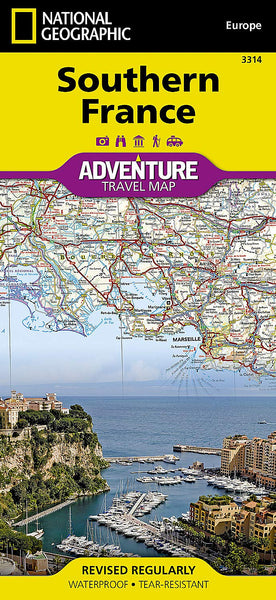
Southern France National Geographic Folded Map
$26.95
Afterpay is only available for orders between $50.00 and $1000.00 More info
Folded Travel Map | Waterproof & Tear-Resistant | Durable Synthetic Material
Covers: French Riviera, Pyrenees, Provence, Languedoc & More
🇫🇷 Discover Southern France with Adventure in Mind
Whether you’re tracing the lavender fields of Provence, navigating the winding roads of the Pyrenees, or sunbathing along the Côte d’Azur, the Southern France Adventure Map by National Geographic is your ideal companion. Purpose-built for adventure travellers, this rugged, richly detailed folded map offers an unbeatable combination of precision, durability, and curated local insight.
Designed to support hiking, road trips, water sports, and cultural exploration, this map brings Southern France to life with a clear focus on terrain, adventure hotspots, and reliable road infrastructure—all in one convenient, pocket-sized format.
🌍 Two-Sided Regional Coverage
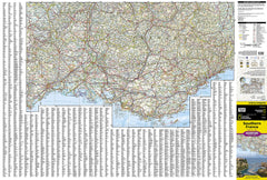
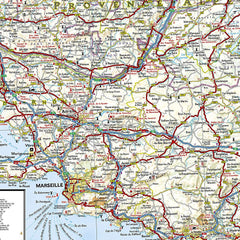
🧭 Front Side – Eastern Southern France
Covers the southeastern corner of France from the Italian border and Monaco to the iconic Mediterranean coastline, including:
-
🇲🇨 Monaco, Nice, Cannes, Saint-Tropez, and the French Riviera
-
🌊 Mediterranean Sea, Golfe du Lion, and the coastline known for diving, sailing, and beaches
-
🏞️ Inland regions of Provence, Verdon Gorge, and national parks
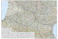
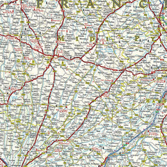
🧭 Reverse Side – Western Southern France
Extends from the Atlantic coastline to the Spanish border and the Pyrenees, including:
-
🌊 The Bay of Biscay, Biarritz, and Basque Country
-
⛰️ The Pyrenees Mountains, Andorra, and the Ariège Valley
-
🍷 Languedoc, Toulouse, Carcassonne, and surrounding rural France
🧭 Map Features
✅ Adventure-Focused Points of Interest
-
Highlights destinations for outdoor activities: snorkeling, surfing, hiking, cycling, skiing, kayaking, fishing, and more
-
Includes UNESCO sites, national parks, cultural landmarks, and historic towns
✅ Clear, Reliable Road Network
-
Road classifications: highways, primary and secondary roads, minor tracks, and scenic routes
-
Accurate road distances, ferry connections, and border crossings
-
Perfect for self-driving tours, van life, or exploring by bike
✅ Easy Navigation & Indexing
-
Thousands of cities, towns, and villages indexed for quick reference
-
Geographic features like rivers, lakes, mountains, and coastline clearly labeled
-
Ideal for trip planning and real-time reference on the go
✅ Rugged Construction for Outdoor Use
-
Printed on tear-resistant, waterproof synthetic paper
-
Folds flat and unfolds easily—no fraying edges or torn creases
-
Designed to handle the rigours of international travel, from city streets to alpine paths
📌 Specifications at a Glance
| Feature | Details |
|---|---|
| Map Type | Folded adventure travel map |
| Brand | National Geographic Maps |
| Region Covered | Southern France (Eastern & Western regions on separate sides) |
| Material | Waterproof, tear-resistant synthetic paper |
| Activities Supported | Hiking, biking, road trips, water sports, cultural exploration |
| Points of Interest | Natural landmarks, parks, UNESCO sites, villages, scenic routes |
| Language | English (legend and place names) |
| Print Origin | Printed in the USA |
👥 Who Is This Map For?
-
🧗♀️ Outdoor adventurers exploring the Pyrenees, coastal trails, or inland river routes
-
🚗 Road trippers and van lifers journeying through the French countryside
-
🏖️ Beach lovers and water sport enthusiasts heading to the Riviera or Atlantic coast
-
🧳 Independent travellers and Euro tourers looking for off-the-beaten-path villages and authentic experiences
-
🗺️ Map collectors and Francophiles who appreciate a practical yet beautifully designed resource
🛒 Add to Your Cart Today
Whether you’re hiking through the gorges of Provence, sipping wine in the hills of Languedoc, or driving the switchbacks of the Pyrenees, this National Geographic Southern France Adventure Map offers the perfect blend of toughness, detail, and inspiration to make every kilometre count.


