- Australia ▾
- Topographic
▾
- Australia AUSTopo 250k (2024)
- Australia 50k Geoscience maps
- Australia 100k Geoscience maps
- Australia 250k Geoscience maps
- Australia 1.1m Geoscience maps
- New Zealand 50k maps
- New Zealand 250k maps
- New South Wales 25k maps
- New South Wales 50k maps
- New South Wales 100k maps
- Queensland 10k maps
- Queensland 25k maps
- Queensland 50k maps
- Queensland 100k maps
- Compasses
- Software
- GPS Systems
- Orienteering
- International ▾
- Wall Maps
▾
- World
- Australia & New Zealand
- Countries, Continents & Regions
- Historical
- Vintage National Geographic
- Australian Capital Territory
- New South Wales
- Northern Territory
- Queensland
- South Australia
- Tasmania
- Victoria
- Western Australia
- Celestial
- Children's
- Mining & Resources
- Wine Maps
- Healthcare
- Postcode Maps
- Electoral Maps
- Nautical ▾
- Flags
▾
- Australian Flag Sets & Banners
- Flag Bunting
- Handwavers
- Australian National Flags
- Aboriginal Flags
- Torres Strait Islander Flags
- International Flags
- Flagpoles & Accessories
- Australian Capital Territory Flags
- New South Wales Flags
- Northern Territory Flags
- Queensland Flags
- South Australia Flags
- Tasmania Flags
- Victoria Flags
- Western Australia Flags
- Gifts ▾
- Globes ▾
Dear valued customer. Please note that our checkout is not supported by old browsers. Please use a recent browser to access all checkout capabilities
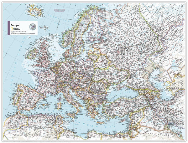
Europe Political Atlas of the World, 11th Edition, National Geographic Wall Map
$69.95
or make 4 interest-free payments of
$17.49 AUD
fortnightly with
![]() More info
More info
Europe Political Wall Map
National Geographic | Atlas of the World, 11th Edition
Standard: 790 × 610 mm | Supermap: 915 × 1197 mm
Published: 2019 | Made in Australia
🧭 Discover Europe with Clarity and Elegance
Bring the full splendour of Europe into your home, classroom, or office with this exquisitely detailed political wall map from National Geographic’s 11th Edition Atlas of the World. Meticulously designed using state-of-the-art cartographic techniques, this map delivers unmatched accuracy, exceptional legibility, and timeless beauty.
This map doesn’t just show where things are — it helps you understand how the nations of Europe connect, how their borders have evolved, and how landscapes influence culture, trade, and history.
🎓 Ideal For:
-
Teachers & Educators – A must-have for geography and social studies classrooms.
-
Students & Homeschoolers – A vibrant, accurate resource for active learning.
-
Travel Enthusiasts & Planners – Dream, plan, and track your European adventures.
-
Offices & Libraries – Adds a polished, informative focal point to any wall.
-
Map Collectors & Decorators – A classic piece from a trusted name in cartography.
🗺️ Map Features
-
Clear Political Boundaries – All European countries shown in distinct colours.
-
Major Cities & Capitals – Includes thousands of place names with legible type placement.
-
Water Bodies & Rivers – Features lakes, seas, and major rivers across the continent.
-
Subtle Shaded Relief – Adds a physical dimension without distracting from political detail.
-
Projection – Drawn in Azimuthal Equidistant projection, which preserves correct distances from the central point — ideal for educational and illustrative use.
-
Legacy Design – Incorporates National Geographic’s iconic style, with over 75 years of trusted mapping heritage.
🖨️ Format Options
| Format | Description |
|---|---|
| Premium Paper | Printed on matte-coated 160 gsm paper, perfect for framing under glass. |
| Laminated | Encapsulated with 80-micron gloss laminate, making it durable, waterproof, and ideal for whiteboard markers or pin use. |
| Canvas | Printed on 395 gsm HP Professional Matte Canvas using fade-resistant pigment inks — rich in texture, colourfast, and built to last. |
| Laminated with Timber Rails | A professional display option — ready to hang with natural timber rails and cord. |
| Canvas with Timber Rails | Our most elegant format — no framing needed, simply hang and admire. |
⏳ Please allow up to 10 working days for delivery of hang-railed versions, as each is custom-assembled by our expert framer.
📐 Specifications
| Detail | Specification |
|---|---|
| Map Title | Europe Political Wall Map |
| Publisher | National Geographic Society |
| Edition | 11th Edition, from the Atlas of the World |
| Published | 2019 |
| Projection | Azimuthal Equidistant |
| Sizes Available | Standard: 790 × 610 mm • Supermap: 915 × 1197 mm |
| Made In | Australia |
🌟 Why Choose This Map?
✅ Legendary Cartographic Detail – From a world-renowned name in exploration and education.
✅ Visually Stunning – Rich colours, clear boundaries, and elegant design make this map a showpiece.
✅ Built to Last – Whether on paper, laminated, or canvas, each version is made with longevity in mind.
✅ Perfect Gift – A meaningful, educational, and beautiful gift for learners, teachers, and travellers.
Step into the story of Europe — where borders meet, histories intertwine, and every country has a tale to tell.
With this map, you're not just seeing Europe — you're experiencing it.


