- Australia ▾
- Topographic
▾
- Australia AUSTopo 250k (2024)
- Australia 50k Geoscience maps
- Australia 100k Geoscience maps
- Australia 250k Geoscience maps
- Australia 1.1m Geoscience maps
- New Zealand 50k maps
- New Zealand 250k maps
- New South Wales 25k maps
- New South Wales 50k maps
- New South Wales 100k maps
- Queensland 10k maps
- Queensland 25k maps
- Queensland 50k maps
- Queensland 100k maps
- Compasses
- Software
- GPS Systems
- Orienteering
- International ▾
- Wall Maps
▾
- World
- Australia & New Zealand
- Countries, Continents & Regions
- Historical
- Vintage National Geographic
- Australian Capital Territory
- New South Wales
- Northern Territory
- Queensland
- South Australia
- Tasmania
- Victoria
- Western Australia
- Celestial
- Children's
- Mining & Resources
- Wine Maps
- Healthcare
- Postcode Maps
- Electoral Maps
- Nautical ▾
- Flags
▾
- Australian Flag Sets & Banners
- Flag Bunting
- Handwavers
- Australian National Flags
- Aboriginal Flags
- Torres Strait Islander Flags
- International Flags
- Flagpoles & Accessories
- Australian Capital Territory Flags
- New South Wales Flags
- Northern Territory Flags
- Queensland Flags
- South Australia Flags
- Tasmania Flags
- Victoria Flags
- Western Australia Flags
- Gifts ▾
- Globes ▾
Dear valued customer. Please note that our checkout is not supported by old browsers. Please use a recent browser to access all checkout capabilities


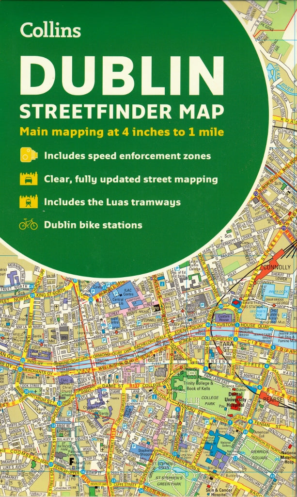
Dublin Streetfinder Collins Map
Sold Out
Afterpay is only available for orders between $50.00 and $1000.00 More info
Street-Level Detail | Durable Card Cover | Fully Indexed
Scale: 1:15,840 (4 inches to 1 mile)
ISBN: 9780008369958
Publisher: HarperCollins Publishers
Edition: 2020 (10th Edition)
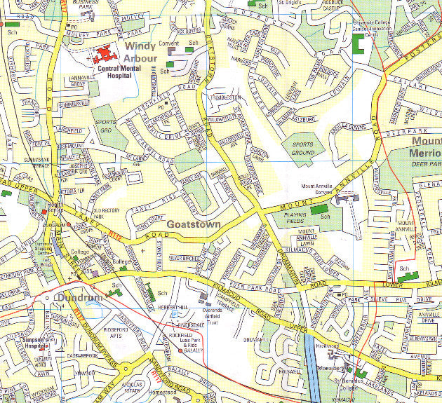
Navigate your way through Ireland’s capital with confidence using the Collins Dublin Streetfinder Colour Map — a clear, full-colour, and street-level map designed for travellers, residents, and professionals alike. Whether you're exploring historic landmarks, locating transport hubs, or planning a business trip, this detailed and fully updated city map offers exceptional clarity, practical information, and durable construction in a compact folded format.
🧭 Detailed Coverage
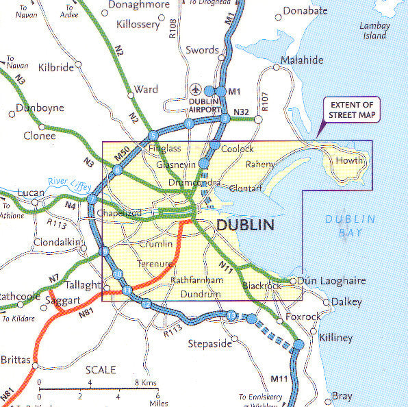
This map provides comprehensive coverage of Dublin, from the coastal neighbourhoods to the city's vibrant inner suburbs:
-
🧭 North – Includes Ballymun, Baldoyle, and Dublin Airport area
-
🌳 West – Covers Phoenix Park, Castleknock, and Blanchardstown
-
🏙️ Central Dublin – Full detail of key districts such as Temple Bar, Grafton Street, St. Stephen’s Green, Trinity College, and O’Connell Street
-
🏞️ South – Extends to Rathmines, Dundrum, and Milltown
-
🌊 East – Stretches to the Dublin Docklands, Sandymount, and the Irish Sea coast
🌟 Key Features
-
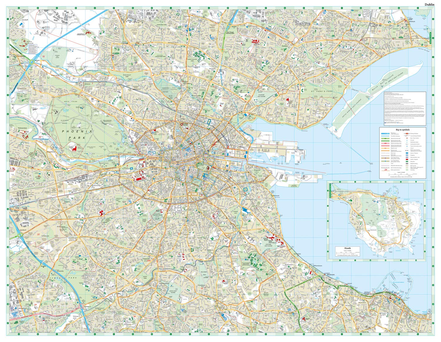
🗺️ Street-Level Mapping
Clear, easy-to-read full-colour map with road names, building footprints, and neighbourhoods fully labeled. -
🧾 Comprehensive Index of Street Names
Quickly locate any street in Dublin with an easy-to-use, alphabetically ordered index. -
🏛️ Tourist Information
Important buildings and points of interest clearly highlighted, including:-
Museums, galleries, and libraries
-
Historic landmarks and statues
-
Hotels, parks, shopping districts, and civic buildings
-
-
🚉 Transport Infrastructure
-
Luas tramlines and stops (Red & Green Lines)
-
Train and DART stations
-
Major bus routes and orbital roads
-
Key road connections and junctions
-
-
🅿️ Practical City Information
-
Public car parks
-
One-way streets and roundabouts
-
Speed enforcement zones
-
Fixed Garda safety camera locations
-
-
📐 Metric Conversion Chart & Map Symbols Guide
Includes helpful tools for navigating speed limits, measurements, and symbols used on the map. -
📚 Bonus Guide to Central Dublin
Historical overview, shopping suggestions, transport tips, and local travel advice included on reverse panel.
📏 Specifications
| Feature | Detail |
|---|---|
| Format | Folded street map with durable card cover |
| Scale | 1:15,840 (4 inches to 1 mile) |
| Map Size (flat) | Approx. 1000 mm x 680 mm (varies slightly) |
| Folded Size | 243 mm x 110 mm (approx. 9.6" x 4.3") |
| Weight | 140 g (approximate) |
| Material | High-quality paper with card cover |
| ISBN | 9780008369958 |
| Language | English |
| Publisher | Collins Maps / HarperCollins UK |
🧳 Who’s It For?
Perfect for:
-
🏠 Dublin residents keeping an up-to-date reference at home or work
-
✈️ Visitors and tourists exploring Dublin’s rich heritage, dining, and nightlife
-
🧭 Backpackers and independent travellers navigating on foot or by public transport
-
🚗 Self-drive travellers and city motorists planning parking and navigation routes
-
💼 Business professionals and delivery drivers who need accurate, quick-reference mapping
-
🎓 Students and educators based at universities across the city
📍 Why Choose the Collins Dublin Streetfinder Map?
-
✅ More detailed than a typical tourist map – great for longer stays and navigating lesser-known areas
-
✅ Stronger and more practical than digital-only solutions – no battery, signal, or glare issues
-
✅ Professionally updated and published – includes recent road developments and transport expansions
-
✅ Easy to fold and store – fits in a handbag, backpack, or glovebox
Whether you're walking the cobbled streets of Temple Bar, catching a Luas tram to Dundrum, or exploring the Georgian architecture of Merrion Square, this durable and comprehensive Collins Dublin Streetfinder Map will help you do it all with confidence and clarity.


