- Australia ▾
- Topographic
▾
- Australia AUSTopo 250k (2024)
- Australia 50k Geoscience maps
- Australia 100k Geoscience maps
- Australia 250k Geoscience maps
- Australia 1.1m Geoscience maps
- New Zealand 50k maps
- New Zealand 250k maps
- New South Wales 25k maps
- New South Wales 50k maps
- New South Wales 100k maps
- Queensland 10k maps
- Queensland 25k maps
- Queensland 50k maps
- Queensland 100k maps
- Compasses
- Software
- GPS Systems
- Orienteering
- International ▾
- Wall Maps
▾
- World
- Australia & New Zealand
- Countries, Continents & Regions
- Historical
- Vintage National Geographic
- Australian Capital Territory
- New South Wales
- Northern Territory
- Queensland
- South Australia
- Tasmania
- Victoria
- Western Australia
- Celestial
- Children's
- Mining & Resources
- Wine Maps
- Healthcare
- Postcode Maps
- Electoral Maps
- Nautical ▾
- Flags
▾
- Australian Flag Sets & Banners
- Flag Bunting
- Handwavers
- Australian National Flags
- Aboriginal Flags
- Torres Strait Islander Flags
- International Flags
- Flagpoles & Accessories
- Australian Capital Territory Flags
- New South Wales Flags
- Northern Territory Flags
- Queensland Flags
- South Australia Flags
- Tasmania Flags
- Victoria Flags
- Western Australia Flags
- Gifts ▾
- Globes ▾
Dear valued customer. Please note that our checkout is not supported by old browsers. Please use a recent browser to access all checkout capabilities
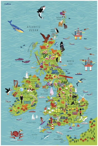
Children's United Kingdom & Ireland Wall Map by Collins 610 x 915mm
$59.95
or make 4 interest-free payments of
$14.99 AUD
fortnightly with
![]() More info
More info
🇬🇧🇮🇪 Children’s United Kingdom & Ireland Wall Map by Collins (Illustrated by Steve Evans)
610 × 915 mm • Paper / Laminated / Laminated + Hang Rails / Canvas / Canvas + Hang Rails • Made in Australia
Spark curiosity with a bright, pictorial tour of the United Kingdom & Ireland—perfect for ages 4–8. Countries and capitals are clearly labelled, while charming illustrations (wildlife, foods, landmarks, sports) turn geography into stories kids can point to, name, and remember.
What Kids Learn at a Glance
-
Countries & capitals: Bold, child-friendly labels aid recognition and recall.
-
Culture & nature: Icons for landmarks, animals, foods, traditions prompt questions and conversation.
-
Early map skills: Symbols, simple legends, compass points 🧭, seas and islands.
-
Vocabulary & memory: Ideal for “find & name” and show-and-tell.
How to Use (Home & Classroom)
-
I-Spy challenges: “Find a castle 🏰 / sheep 🐑 / football ⚽ / lighthouse.”
-
Story starters: Pick an icon and invent a travel tale through that region.
-
Map talk: Practice near/far, north/south, island/sea, borders, and directions.
-
Cross-curricular links: Geography, literacy (naming & describing), art (icon sketching), civics (nations & flags).
Finishes & Display Options
-
📄 Paper — FSC® 160 gsm Matte-Coated
Smooth, low-glare stock ideal for framing under glass. Printed with archival Hewlett-Packard pigment inks for excellent fade resistance. -
💧 Laminated — True Encapsulation
Printed on 120 gsm and sealed in 2 × 80-micron gloss laminate (edge-sealed).
Wipe-clean • Tear-resistant • Moisture-safe — use non-permanent whiteboard markers and map dots. -
🪵 Laminated + Timber Hang Rails — Ready to Hang
Natural lacquered timber rails (top & bottom) + top hanging cord.
Clean, frame-free presentation—hang from a single hook.
⏱️ Please allow up to 10 working days for rail fitting. -
🖼️ Canvas — HP 395 gsm Professional Matte
Gallery-grade canvas + archival HP pigment inks for rich detail and long-term fade resistance. -
🪵 Canvas + Timber Hang Rails
The same premium canvas, finished with natural timber rails + top hanging cord—ready to hang.
⏱️ Please allow up to 10 working days for rail fitting.
Dry-erase markers are recommended only on laminated versions.
Specifications
| Attribute | Details |
|---|---|
| Title | Children’s United Kingdom & Ireland Wall Map (Collins) |
| Illustrator | Steve Evans |
| Audience | Ages 4–8 |
| Size | 610 mm (W) × 915 mm (H) |
| Content | Countries, capitals, pictorial icons (animals, foods, landmarks, sport) |
| Formats | Paper • Laminated • Laminated + Hang Rails • Canvas • Canvas + Hang Rails |
| Printing | Archival HP pigment inks (fade-resistant) |
| Paper | FSC® 160 gsm matte-coated |
| Canvas | HP 395 gsm Professional Matte |
| Origin | Made in Australia |
Where It Belongs
Classrooms • Libraries • Playrooms • After-school programs • Pediatric waiting rooms • Home learning corners
Bundle Ideas
-
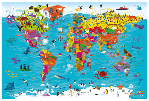
Pair with Children’s Europe / World maps for continental context.
-
Add a compass rose poster or flags of the world chart for quick link-ups.
-
Create a “travel corner” with a globe and reading basket of UK & Ireland stories.
Our Commitment
-
Local craftsmanship: Printed and finished in Australia.
-
Sustainable materials: FSC® papers and long-life HP pigment inks.
-
Kid-ready clarity: Colours, icons, and labels tuned for wall readability.
-
Packed with care: Hand-checked and securely boxed to arrive display-ready.
Bring the UK & Ireland to the wall—bright, friendly, and endlessly explorable. Choose your finish and make geography their new favourite adventure.


