- Australia ▾
- Topographic
▾
- Australia AUSTopo 250k (2024)
- Australia 50k Geoscience maps
- Australia 100k Geoscience maps
- Australia 250k Geoscience maps
- Australia 1.1m Geoscience maps
- New Zealand 50k maps
- New Zealand 250k maps
- New South Wales 25k maps
- New South Wales 50k maps
- New South Wales 100k maps
- Queensland 10k maps
- Queensland 25k maps
- Queensland 50k maps
- Queensland 100k maps
- Compasses
- Software
- GPS Systems
- Orienteering
- International ▾
- Wall Maps
▾
- World
- Australia & New Zealand
- Countries, Continents & Regions
- Historical
- Vintage National Geographic
- Australian Capital Territory
- New South Wales
- Northern Territory
- Queensland
- South Australia
- Tasmania
- Victoria
- Western Australia
- Celestial
- Children's
- Mining & Resources
- Wine Maps
- Healthcare
- Postcode Maps
- Electoral Maps
- Nautical ▾
- Flags
▾
- Australian Flag Sets & Banners
- Flag Bunting
- Handwavers
- Australian National Flags
- Aboriginal Flags
- Torres Strait Islander Flags
- International Flags
- Flagpoles & Accessories
- Australian Capital Territory Flags
- New South Wales Flags
- Northern Territory Flags
- Queensland Flags
- South Australia Flags
- Tasmania Flags
- Victoria Flags
- Western Australia Flags
- Gifts ▾
- Globes ▾
Dear valued customer. Please note that our checkout is not supported by old browsers. Please use a recent browser to access all checkout capabilities


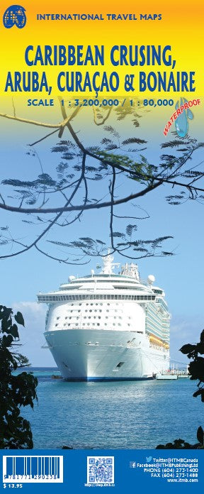
Caribbean Cruising, Aruba, Curacao, Bonaire ITMB Map
$24.95
Afterpay is only available for orders between $50.00 and $1000.00 More info
Double-Sided Waterproof Map | Cruise Ports & Island Detail | Stone Paper Edition
Covers: Aruba • Bonaire • Curaçao • Caribbean Sea Region
Size: 990 mm x 680 mm | Waterproof & Tear-Resistant | 2-in-1 Map Title
Explore the tropical beauty and fascinating history of the Dutch Antilles while also navigating the full scope of the Caribbean’s most iconic cruising destinations. This double-sided map by ITMB is printed on durable, waterproof stone paper, and includes two covers—making it perfect for sale as either a Caribbean Cruising Map or a focused map of Aruba, Bonaire, and Curaçao.
Whether you're planning a cruise, a resort stay, or simply collecting beautiful maps of the Caribbean, this title offers an immersive and practical experience.
🌴 What This Map Covers
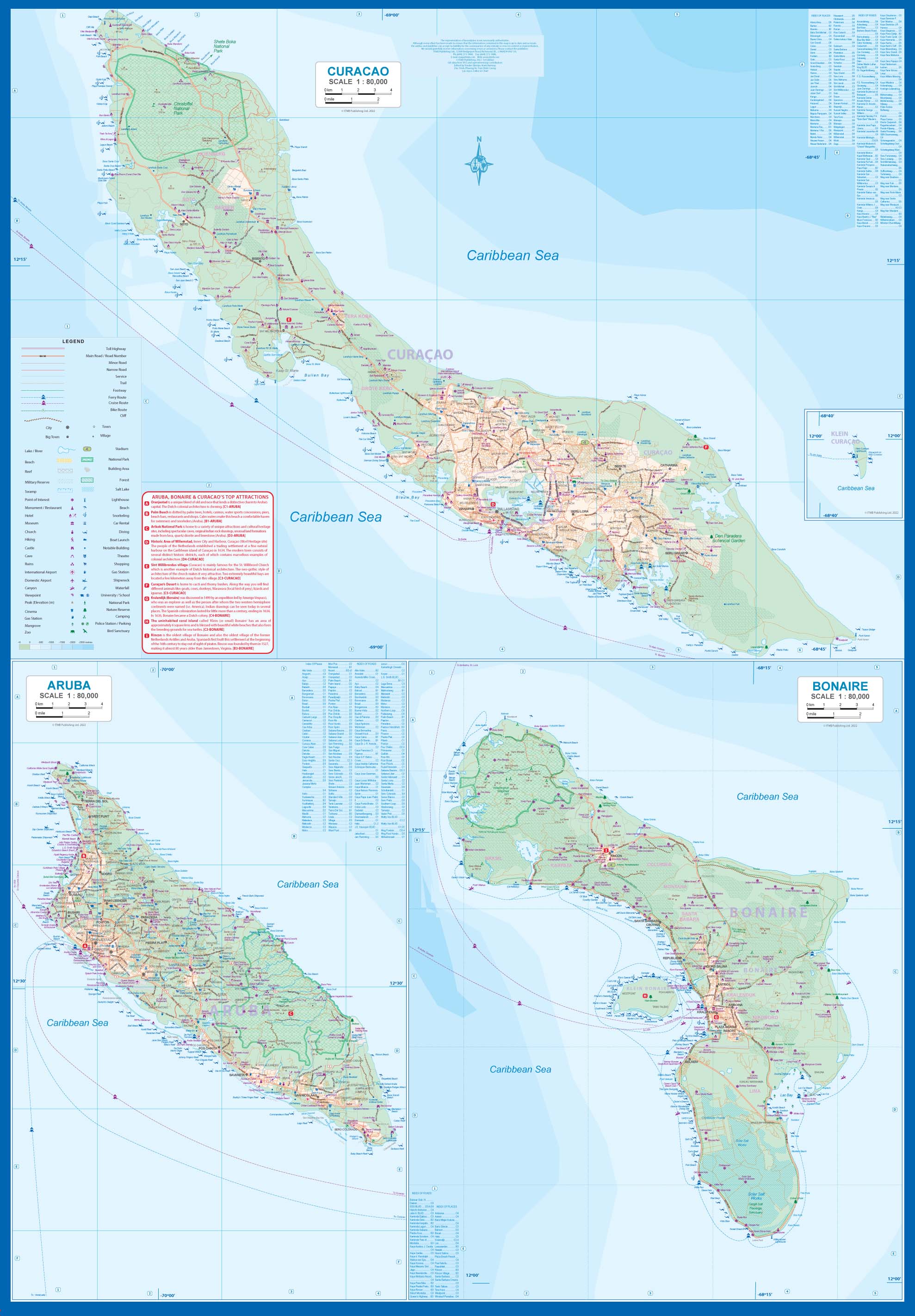
🔹 Side 1 – Aruba, Bonaire & Curaçao (Dutch Antilles)
-
Detailed topographic maps of:
-
Aruba – known for its desert-like landscape and pristine beaches
-
Curaçao – colourful colonial architecture in Willemstad and coastal charm
-
Bonaire – tranquil, eco-focused tourism and historic towns like Rincon, founded in 1527
-
-
Roads, resorts, beaches, diving spots, and cultural landmarks all clearly marked
-
Historic and cultural notes on Dutch influence and early exploration
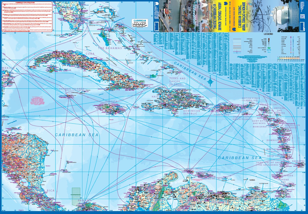
🔹 Side 2 – Caribbean Cruising Region Map
-
Broad overview from:
-
🗺️ Florida Keys & Bahamas in the north
-
🌎 South to the coasts of Venezuela & Colombia
-
🧭 West to Central America and east to Barbados
-
-
Every major cruise port marked, including:
-
🇲🇽 Cozumel, 🇯🇲 Montego Bay, 🇧🇸 Nassau, 🇻🇨 Kingstown, 🇧🇧 Bridgetown, and more
-
🌊 Navassa Island – a disputed speck of land between the USA and Haiti
-
-
Lesser-known destinations like:
-
🇻🇪 Margarita Island
-
🇭🇳 Cayo Mayor
-
🇳🇮 San Andrés
-
📌 Key Features
| Feature | Description |
|---|---|
| 🧭 Two Maps in One | Side 1: Aruba, Bonaire & Curaçao • Side 2: Full Caribbean cruise region |
| 🛳️ Cruise Ports Highlighted | Every major and minor Caribbean cruise stop labeled |
| 🌍 Lesser-Known Islands | Includes hidden gems like Margarita, San Andrés, and Cayo Mayor |
| 📏 Detailed Scales | Island side: detailed island mapping • Cruise side: regional overview |
| 💧 Waterproof & Tear-Resistant | Printed on durable stone paper – ideal for tropical conditions |
| 📐 Compact Folded Format | Easy to carry and use during cruises or tours |
| 📚 Historical & Cultural Info | Includes fun facts and historical references about each destination |
📐 Product Specifications
| Specification | Detail |
|---|---|
| Title | Caribbean Cruising / Aruba, Bonaire & Curaçao Map |
| Publisher | ITMB – International Travel Maps |
| Format | Folded, double-sided waterproof map |
| Size | 990 mm (W) x 680 mm (H) (unfolded) |
| Material | Waterproof, tear-resistant stone paper |
| Edition | Latest available |
| Cover Style | Dual-title: Marketed as either Caribbean Cruising or ABC Islands Map |
🎯 Ideal For:
-
🛳️ Cruise travellers planning Caribbean itineraries
-
🏝️ Visitors to Aruba, Bonaire & Curaçao seeking a portable island guide
-
📚 Students, educators & researchers focused on Caribbean geography and history
-
🗺️ Map collectors & travel planners
-
🧳 Backpackers & independent travellers looking for lesser-known island stops
🛒 Add to Cart – Sail the Caribbean in Style
From high-profile cruise ports to secluded tropical hideaways, this map puts the entire Caribbean Sea in your hands—while offering beautifully detailed views of three of the region’s most culturally rich and visually stunning islands.
💧 Waterproof, foldable, and rich in information—ideal for decks, docks, backpacks, and bookshelves.


