- Australia ▾
- Topographic
▾
- Australia AUSTopo 250k (2024)
- Australia 50k Geoscience maps
- Australia 100k Geoscience maps
- Australia 250k Geoscience maps
- Australia 1.1m Geoscience maps
- New Zealand 50k maps
- New Zealand 250k maps
- New South Wales 25k maps
- New South Wales 50k maps
- New South Wales 100k maps
- Queensland 10k maps
- Queensland 25k maps
- Queensland 50k maps
- Queensland 100k maps
- Compasses
- Software
- GPS Systems
- Orienteering
- International ▾
- Wall Maps
▾
- World
- Australia & New Zealand
- Countries, Continents & Regions
- Historical
- Vintage National Geographic
- Australian Capital Territory
- New South Wales
- Northern Territory
- Queensland
- South Australia
- Tasmania
- Victoria
- Western Australia
- Celestial
- Children's
- Mining & Resources
- Wine Maps
- Healthcare
- Postcode Maps
- Electoral Maps
- Nautical ▾
- Flags
▾
- Australian Flag Sets & Banners
- Flag Bunting
- Handwavers
- Australian National Flags
- Aboriginal Flags
- Torres Strait Islander Flags
- International Flags
- Flagpoles & Accessories
- Australian Capital Territory Flags
- New South Wales Flags
- Northern Territory Flags
- Queensland Flags
- South Australia Flags
- Tasmania Flags
- Victoria Flags
- Western Australia Flags
- Gifts ▾
- Globes ▾
Dear valued customer. Please note that our checkout is not supported by old browsers. Please use a recent browser to access all checkout capabilities


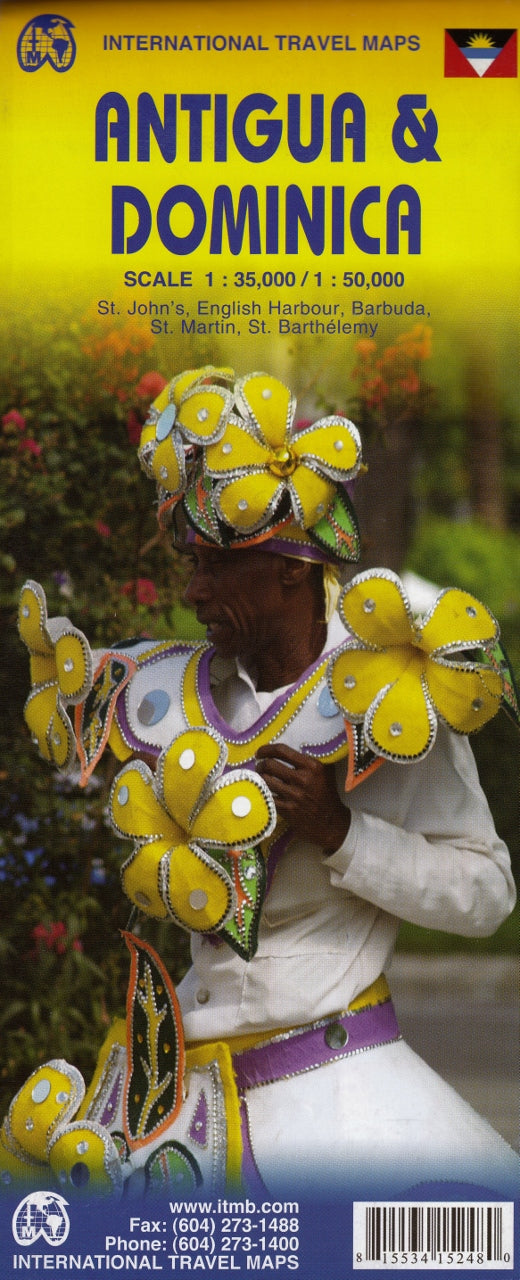
Antigua & Dominica ITMB Map
$24.95
Afterpay is only available for orders between $50.00 and $1000.00 More info
Double-Sided | Updated Cartography | Caribbean Island Explorer's Essential
Scale: 1:35,000 / 1:50,000 | Size: 990 mm x 680 mm | Waterproof Paper
Explore the tropical heart of the Eastern Caribbean with this highly detailed and updated double-sided map of Antigua & Dominica by ITMB (International Travel Maps). Designed for travelers, sailors, and Caribbean enthusiasts, this map offers clear, modern cartography, highlighting roads, terrain, coastal features, towns, and tourist sites across these stunning island nations.
With multiple insets and expanded coverage of nearby islands, this map is ideal for planning, exploring, or educational reference.
🏝️ What’s On This Map?
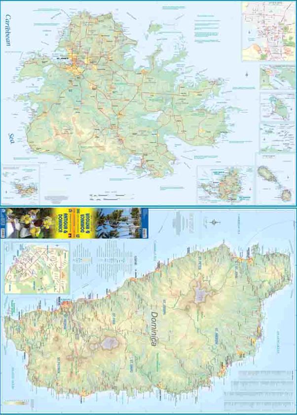
Side 1 – Antigua & Surrounding Islands
-
Main map of Antigua at a detailed scale of 1:35,000
-
Insets include:
-
🏙️ St. John’s (capital city)
-
⚓ Nelson’s Dockyard at English Harbour
-
🏝️ Barbuda – Antigua’s quiet sister island
-
🗺️ St. Barthelemy (St. Barth’s)
-
🇫🇷/🇳🇱 Sint Maarten (Dutch side) / Saint-Martin (French side)
-
Side 2 – Dominica
-
Full map of Dominica at 1:50,000 scale
-
Detailed road and walking trail network
-
Includes rivers, national parks, hot springs, and coastal features
📌 Key Features
| Feature | Description |
|---|---|
| 🗺️ Updated Cartography | Improved digital data for more accurate and modern mapping |
| 🏝️ Multi-Island Coverage | Includes Antigua, Dominica, Barbuda, St. Barth's, Saint-Martin & Sint Maarten |
| 🌋 Natural Features | Shows volcanoes, parks, hot springs, reefs, and natural reserves |
| 🛣️ Road & Trail Networks | Marked roads, tracks, and walking trails for urban and rural areas |
| 🏙️ City Insets | Focus maps of St. John’s and English Harbour for local exploration |
| 📏 Dual Scales | Antigua: 1:35,000 / Dominica: 1:50,000 |
| 💧 Waterproof Paper | Durable and ideal for tropical travel |
| 📐 Compact Folded Format | Easy to pack, fold, and unfold while on the go |
📐 Product Specifications
| Specification | Detail |
|---|---|
| Title | Antigua & Dominica Travel Map |
| Publisher | ITMB – International Travel Maps |
| Format | Folded, double-sided map |
| Size | 990 mm (W) x 680 mm (H) (unfolded) |
| Scales | Antigua 1:35,000 / Dominica 1:50,000 |
| Full colour with shaded relief | |
| Paper Type | Waterproof, tear-resistant |
| Edition | Latest available |
🎯 Perfect For:
-
🧳 Independent travellers & backpackers exploring the Caribbean
-
⚓ Sailors, cruisers & charter tourists hopping between islands
-
🗺️ Map collectors & geography educators looking for up-to-date regional references
-
🌿 Eco-tourists & hikers planning treks or nature walks on Dominica
-
📚 Students & researchers interested in Caribbean island geography
🛒 Add to Cart – Navigate the Caribbean With Confidence
From the colonial charm of St. John’s to the volcanic peaks and rainforests of Dominica, this beautifully updated Antigua & Dominica map by ITMB brings the Eastern Caribbean into focus—helping you plan, explore, and appreciate every stop along the way.
✈️ Lightweight, packable, and printed on waterproof stock—this is your ideal island-hopping companion.


