- Australia ▾
- Topographic
▾
- Australia AUSTopo 250k (2024)
- Australia 50k Geoscience maps
- Australia 100k Geoscience maps
- Australia 250k Geoscience maps
- Australia 1.1m Geoscience maps
- New Zealand 50k maps
- New Zealand 250k maps
- New South Wales 25k maps
- New South Wales 50k maps
- New South Wales 100k maps
- Queensland 10k maps
- Queensland 25k maps
- Queensland 50k maps
- Queensland 100k maps
- Compasses
- Software
- GPS Systems
- Orienteering
- International ▾
- Wall Maps
▾
- World
- Australia & New Zealand
- Countries, Continents & Regions
- Historical
- Vintage National Geographic
- Australian Capital Territory
- New South Wales
- Northern Territory
- Queensland
- South Australia
- Tasmania
- Victoria
- Western Australia
- Celestial
- Children's
- Mining & Resources
- Wine Maps
- Healthcare
- Postcode Maps
- Electoral Maps
- Nautical ▾
- Flags
▾
- Australian Flag Sets & Banners
- Flag Bunting
- Handwavers
- Australian National Flags
- Aboriginal Flags
- Torres Strait Islander Flags
- International Flags
- Flagpoles & Accessories
- Australian Capital Territory Flags
- New South Wales Flags
- Northern Territory Flags
- Queensland Flags
- South Australia Flags
- Tasmania Flags
- Victoria Flags
- Western Australia Flags
- Gifts ▾
- Globes ▾
Dear valued customer. Please note that our checkout is not supported by old browsers. Please use a recent browser to access all checkout capabilities


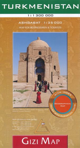
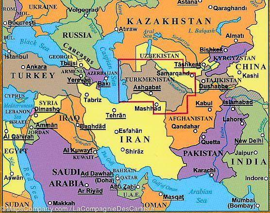
Turkmenistan Gizi Maps Folded
$29.95
Afterpay is only available for orders between $50.00 and $1000.00 More info
Single-Sided Travel & Terrain Map | Scale: 1:1,300,000
Size: 1000 mm x 930 mm | Includes Comprehensive Place Name Index
Print-on-Demand – Please Allow Up to 10 Working Days for Delivery
🌍 Discover One of Central Asia’s Least-Explored Nations with a Trusted Map
Vast deserts, ancient Silk Road cities, and striking natural landscapes define Turkmenistan—a country full of mystery and off-the-beaten-path adventure. The Gizi Maps Turkmenistan Folded Map offers a rare and detailed view of this remote Central Asian nation, combining reliable road and topographic detail with highlights of tourist sites and services.
At a practical 1:1,300,000 scale, this single-sided map is ideal for travellers, researchers, and map enthusiasts alike who want to explore or study the region with confidence.
🧭 Key Features
✅ Full Country Coverage on One Sheet
-
Detailed overview of Turkmenistan’s terrain, infrastructure, and borders
-
Includes major cities like Ashgabat, Mary, Dashoguz, and Turkmenabat, as well as remote desert settlements and oases
-
Borders with Iran, Afghanistan, Uzbekistan, and the Caspian Sea clearly shown
✅ Topographic Relief & Elevation Shading
-
Colour shading and gradient tints reflect the country’s unique geography, from the Karakum Desert to the Kopet Dag Mountains
-
Spot heights and elevation markings help visualise terrain changes
✅ Road & Transport Network
-
Major and secondary roads, desert tracks, and rural routes are clearly marked
-
Includes road distances for trip planning
-
Key border crossings, airports, and transport hubs indicated
✅ Tourist & Cultural Sites
-
Map symbols denote the locations of:
-
🕌 Mosques, temples, and monuments
-
🏞️ National parks and protected areas
-
🏯 Historical landmarks and cultural points of interest
-
🏨 Tourist services, accommodations, and visitor centres
-
✅ Place Name Index
-
Comprehensive index of cities, towns, villages, and geographic features
-
Ideal for cross-referencing routes, academic use, or location searches
📐 Specifications at a Glance
| Feature | Details |
|---|---|
| Map Type | Folded, single-sided map |
| Publisher | Gizi Maps |
| Scale | 1:1,300,000 |
| Size (Unfolded) | 1000 mm x 930 mm (approx. 39.4" x 36.6") |
| Topography | Colour-shaded elevation, gradient tints, spot heights |
| Tourism Info | Symbols for cultural sites, services, and attractions |
| Place Name Index | Included |
| Language | English (legend and place names) |
| Material | High-quality paper |
👥 Who Is This Map For?
-
🧭 Adventure travellers and overlanders exploring Central Asia’s lesser-known routes
-
🧳 Tourists and researchers visiting archaeological sites and ancient Silk Road cities
-
🚗 Drivers and cyclists planning long-distance or cross-border journeys
-
📚 Educators and geography students studying the region’s terrain and borders
-
🗺️ Map collectors seeking rare and high-quality cartographic coverage of Central Asia
🕒 Ordered-on-Demand – Please Allow Extra Time for Delivery
📦 This map is ordered on demand from the publisher. Please allow up to 10 working days for delivery.
🛒 Add the Gizi Turkmenistan Map to Your Cart Today
A rare, richly detailed map of one of the world's most underexplored destinations—perfect for planning, reference, or collecting.