- Australia ▾
- Topographic
▾
- Australia AUSTopo 250k (2025)
- Australia 50k Geoscience maps
- Australia 100k Geoscience maps
- Australia 250k Geoscience maps
- Australia 1.1m Geoscience maps
- New Zealand 50k maps
- New Zealand 250k maps
- New South Wales 25k maps
- New South Wales 50k maps
- New South Wales 100k maps
- Queensland 10k maps
- Queensland 25k maps
- Queensland 50k maps
- Queensland 100k maps
- Compasses
- Software
- GPS Systems
- Orienteering
- International ▾
- Wall Maps
▾
- World
- Australia & New Zealand
- Countries, Continents & Regions
- Historical
- Vintage National Geographic
- Australian Capital Territory
- New South Wales
- Northern Territory
- Queensland
- South Australia
- Tasmania
- Victoria
- Western Australia
- Celestial
- Children's
- Mining & Resources
- Wine Maps
- Healthcare
- Postcode Maps
- Electoral Maps
- Nautical ▾
- Flags
▾
- Australian Flag Sets & Banners
- Flag Bunting
- Handwavers
- Australian National Flags
- Aboriginal Flags
- Torres Strait Islander Flags
- International Flags
- Flagpoles & Accessories
- Australian Capital Territory Flags
- New South Wales Flags
- Northern Territory Flags
- Queensland Flags
- South Australia Flags
- Tasmania Flags
- Victoria Flags
- Western Australia Flags
- Gifts ▾
- Globes ▾
Dear valued customer. Please note that our checkout is not supported by old browsers. Please use a recent browser to access all checkout capabilities


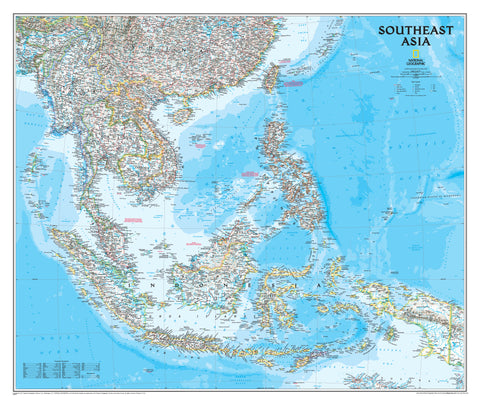
South East Asia ITMB Map
$24.95
Afterpay is only available for orders between $50.00 and $1000.00 More info
Explore the Cultures, Coasts, and Islands of a Vast and Vibrant Region
Scale: 1:4,000,000
Size: 690 mm x 1000 mm
Available Laminated for Long-Term Use
Covering the region from southern China through the Indochinese peninsula, and sweeping across the Indonesian archipelago to the Philippines, the South East Asia Map by ITMB (International Travel Maps) offers a richly detailed view of one of the most culturally, economically, and geographically diverse parts of the world.
This double-sided map captures the essence of a region that includes towering mountains, bustling metropolises, tropical coastlines, island nations, and centuries of intertwined cultures. Whether you're planning a multi-country backpacking trip, working in international development, or simply fascinated by this extraordinary part of the world, this map offers both clarity and insight.
🌏 Regional Coverage Includes:
-
🇨🇳 Southern China (Yunnan, Guangxi, Hainan)
-
🇹🇭 Thailand, 🇱🇦 Laos, 🇰🇭 Cambodia, 🇻🇳 Vietnam, 🇲🇲 Myanmar
-
🇲🇾 Malaysia, 🇸🇬 Singapore, 🇧🇳 Brunei
-
🇮🇩 Indonesia (Java, Bali, Sumatra, Borneo, and more)
-
🇵🇭 The Philippines, with hundreds of island groupings clearly marked
-
🇹🇱 Timor-Leste and surrounding seas
🧭 Key Features:
-
🛣️ Road networks by classification – motorways, major highways, divided roads, and minor routes
-
🚄 Railway lines and tunnels, key ferry routes, and international ports
-
🌋 Geographic detail including rivers, mountains, coral reefs, active volcanoes, and national parks
-
🛕 Cultural and tourist highlights, such as temples, churches, mosques, caves, tombs, markets, beaches, and hot springs
-
🛬 International airports, regional landing strips, and major transport hubs
-
🧭 Clearly marked international borders, major cities, and capitals
🗺️ Legend Includes Symbols For:
-
Roads (motorway, major highway, minor roads)
-
Railways and tunnels
-
Airports, seaports, and ferry routes
-
National parks and conservation zones
-
Coral reefs, marshes, deserts, and river systems
-
Cultural sites: Chinese temples, mosques, churches, historic ruins, tombs
-
Tourist activities: markets, hot springs, beach resorts, canoeing, sailing, and more
This map is not only a navigation aid, but a visual journey through Southeast Asia’s immense variety of terrain, culture, and lifestyle.
🖨️ Optional Laminated Edition
Upgrade your map to a laminated version for added durability and interactivity:
-
✅ Encapsulated in 80-micron gloss laminate – fully waterproof and tear-resistant
-
✅ Wipe-clean surface for whiteboard marker use
-
✅ Compatible with map dots to mark travel routes, visited locations, or future destinations
-
✅ Ideal for classrooms, travel agencies, or adventure planning walls
⚠️ Please note: Laminated maps are made from flattened folded versions. Some light fold lines may remain visible beneath the laminate.
📐 Specifications
| Feature | Detail |
|---|---|
| Map Title | South East Asia Travel Map – ITMB |
| Publisher | International Travel Maps (Canada) |
| Scale | 1:4,000,000 |
| Size (Flat) | 690 mm x 1000 mm |
| Print Format | Double-sided |
| Finish Options | Folded paper or laminated |
| Legend Languages | English |
| Printed In | Canada |
🧳 Perfect For:
-
🌍 Backpackers and overland travellers planning extended trips across Asia
-
🧭 Travel agents and tour operators requiring regional overviews
-
🎓 Educators and geography classrooms looking for a clear, up-to-date regional map
-
🌏 Expats, NGOs, and business professionals working across Southeast Asia
-
📌 Wall display in offices or travel-themed spaces
The South East Asia Map by ITMB is an essential tool for understanding, navigating, and appreciating the incredible diversity of this globally significant region. With its vibrant cartography, practical layout, and rich geographic and cultural data, it’s the ideal map for travellers, professionals, and curious minds alike.
Plan globally. Travel regionally. Explore Southeast Asia.