- Australia ▾
- Topographic
▾
- Australia AUSTopo 250k (2024)
- Australia 50k Geoscience maps
- Australia 100k Geoscience maps
- Australia 250k Geoscience maps
- Australia 1.1m Geoscience maps
- New Zealand 50k maps
- New Zealand 250k maps
- New South Wales 25k maps
- New South Wales 50k maps
- New South Wales 100k maps
- Queensland 10k maps
- Queensland 25k maps
- Queensland 50k maps
- Queensland 100k maps
- Compasses
- Software
- GPS Systems
- Orienteering
- International ▾
- Wall Maps
▾
- World
- Australia & New Zealand
- Countries, Continents & Regions
- Historical
- Vintage National Geographic
- Australian Capital Territory
- New South Wales
- Northern Territory
- Queensland
- South Australia
- Tasmania
- Victoria
- Western Australia
- Celestial
- Children's
- Mining & Resources
- Wine Maps
- Healthcare
- Postcode Maps
- Electoral Maps
- Nautical ▾
- Flags
▾
- Australian Flag Sets & Banners
- Flag Bunting
- Handwavers
- Australian National Flags
- Aboriginal Flags
- Torres Strait Islander Flags
- International Flags
- Flagpoles & Accessories
- Australian Capital Territory Flags
- New South Wales Flags
- Northern Territory Flags
- Queensland Flags
- South Australia Flags
- Tasmania Flags
- Victoria Flags
- Western Australia Flags
- Gifts ▾
- Globes ▾
Dear valued customer. Please note that our checkout is not supported by old browsers. Please use a recent browser to access all checkout capabilities


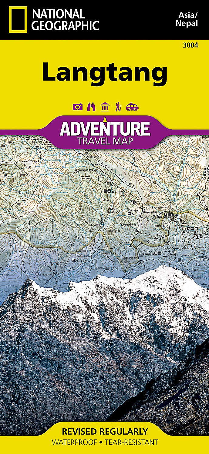
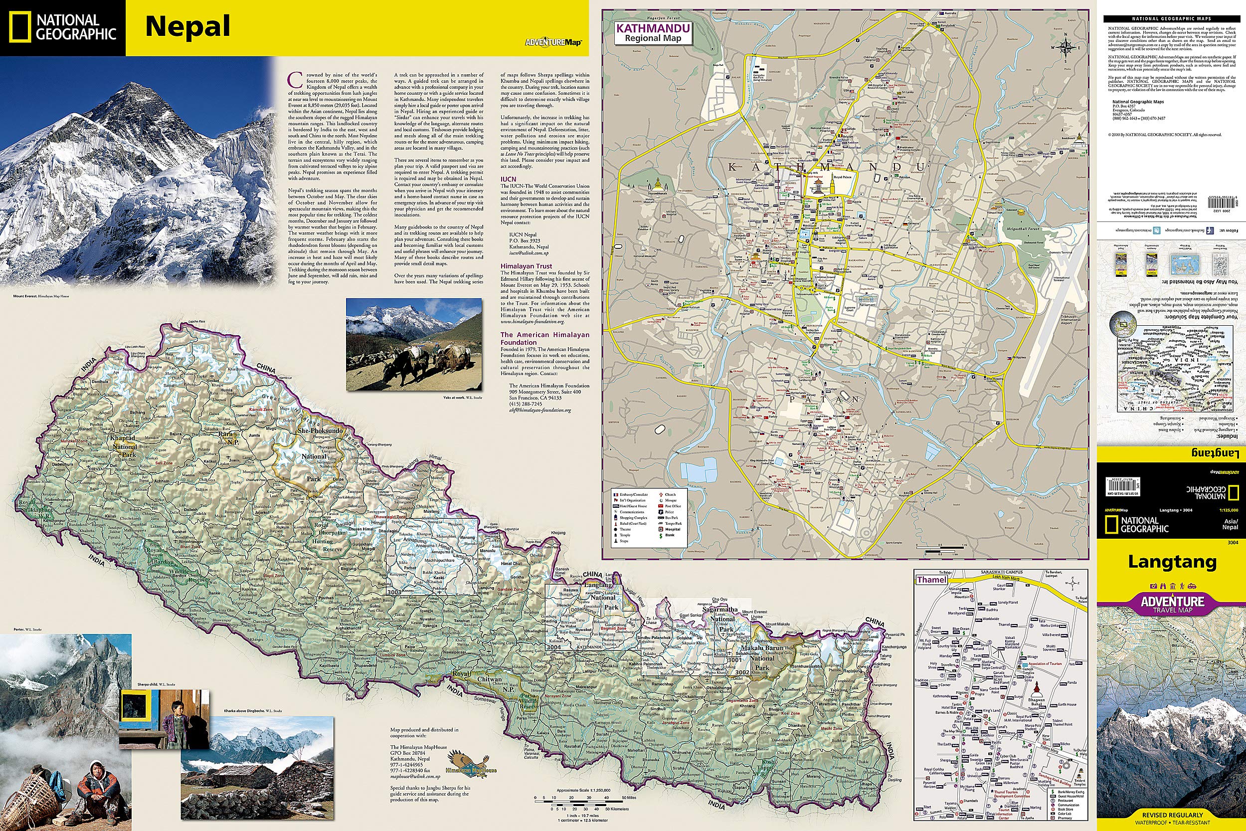
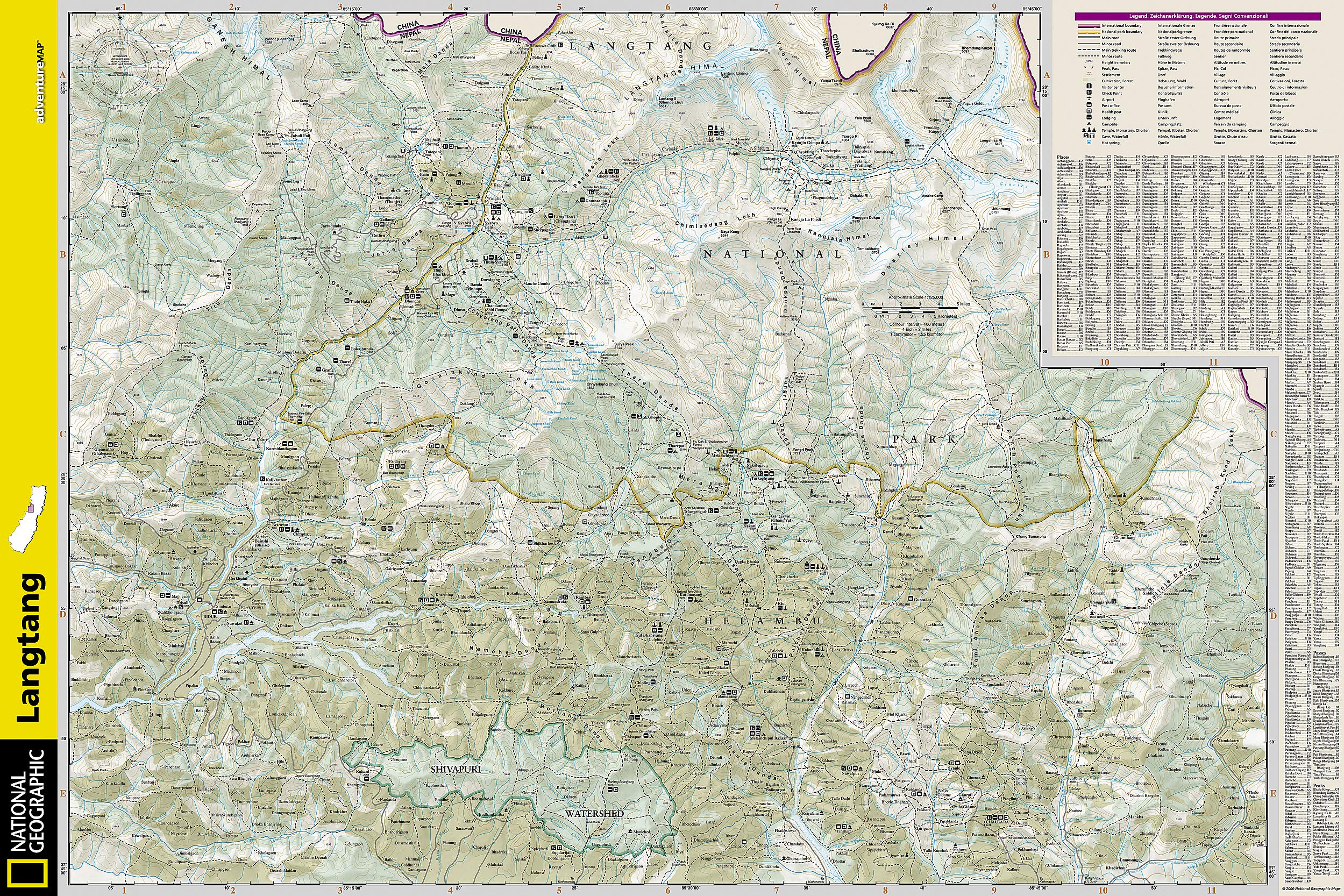
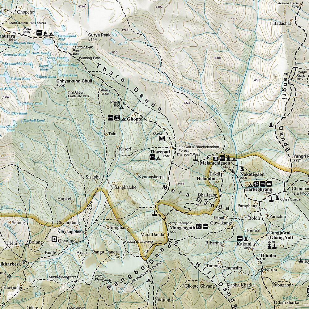
Langtang National Geographic Folded Map
$27.95
Afterpay is only available for orders between $50.00 and $1000.00 More info
🏔️ Langtang, Nepal Adventure Map – National Geographic
Durable Folded Trekking & Travel Map | Waterproof & Tear-Resistant | Scale 1:100,000
Discover the breathtaking Langtang Valley and surrounding regions of northern Nepal with National Geographic’s Langtang Adventure Map—an essential companion for trekkers, explorers, and cultural travellers alike. Renowned for its accuracy, durability, and thoughtful design, this map offers the perfect balance of detail and clarity, allowing you to navigate one of Nepal’s most stunning high-altitude destinations with confidence.
Covering one of the most beloved trekking regions outside of the Everest and Annapurna circuits, this map is ideal for those planning to walk the Langtang Valley, Helambu, Gosaikunda Lakes, or Tamang Heritage Trail.
🧭 Key Features at a Glance
| 🌍 Feature | ✅ Description |
|---|---|
| Region Covered | Langtang National Park and surrounding trekking areas |
| Scale | 1:100,000 – ideal for trekking and regional travel |
| Map Format | Two-sided folded map with packable design |
| Material | Printed on waterproof, tear-resistant synthetic paper |
| Folded Size | 235 x 108 mm (fits in a pocket or map case) |
| Unfolded Size | 965 x 660 mm |
| Trekking Routes Shown | Langtang Valley, Gosaikunda Lakes, Helambu, Tamang Heritage Trail |
| Topographic Detail | Contours, rivers, glaciers, elevation shading |
| Transportation | Roads, trails, footpaths, bridges, trailheads |
| Points of Interest | Monasteries, villages, teahouses, scenic viewpoints, natural and cultural sites |
| Index | Fully indexed with cities, villages, peaks, and key landmarks |
🏞️ Why Choose This Map?
-
Purpose-Built for Trekking & Travel: Designed specifically for outdoor adventure, this map highlights established trekking routes, village names, elevations, and access points—helping you plan multi-day hikes or shorter cultural walks with ease.
-
Cultural Insight Meets Geographic Accuracy: Beyond physical features, the map marks religious sites, gompas, sacred lakes, viewpoints, and significant settlements in this culturally rich region bordering Tibet.
-
Navigation Confidence in All Conditions: Built to endure Nepal’s mountain weather, the synthetic paper is fully waterproof and tear-resistant, making it ideal for use in rain, snow, or dusty trail conditions.
-
Part of the Renowned Adventure Map Series: Trusted by travellers around the world, National Geographic’s Adventure Maps are the gold standard for serious explorers, offering a level of cartographic excellence rarely matched.
🧳 Ideal For:
-
🥾 Trekking Langtang Valley, Helambu & Gosaikunda
-
📸 Adventure photographers & hikers seeking remote trails
-
🏕️ Backpackers and solo travellers in Nepal
-
🌍 Students or researchers exploring Himalayan geography & culture
-
🎁 Gifting to trekkers, travel lovers, or Nepal enthusiasts
Whether you're walking through ancient Tamang villages or climbing toward the sacred alpine lakes of Gosaikunda, this map ensures you're never lost—just exploring.
Perfect for pre-trip planning, trail navigation, and a lasting souvenir of your journey.