- Australia ▾
- Topographic
▾
- Australia AUSTopo 250k (2025)
- Australia 50k Geoscience maps
- Australia 100k Geoscience maps
- Australia 250k Geoscience maps
- Australia 1:1m Geoscience maps
- New Zealand 50k maps
- New Zealand 250k maps
- New South Wales 25k maps
- New South Wales 50k maps
- New South Wales 100k maps
- Queensland 10k maps
- Queensland 25k maps
- Queensland 50k maps
- Queensland 100k maps
- Western Australia 25k maps
- Western Australia 50k maps
- Western Australia 100k maps
- Compasses
- Software
- GPS Systems
- International ▾
- Wall Maps
▾
- World
- Australia & New Zealand
- Countries, Continents & Regions
- Historical
- Vintage National Geographic
- Australian Capital Territory
- New South Wales
- Northern Territory
- Queensland
- South Australia
- Tasmania
- Victoria
- Western Australia
- Celestial
- Children's
- Mining & Resources
- Wine Maps
- Healthcare
- Postcode Maps
- Electoral Maps
- Nautical ▾
- Flags
▾
- Australian Flag Sets & Banners
- Flag Bunting
- Handwavers
- Australian National Flags
- Aboriginal Flags
- Torres Strait Islander Flags
- International Flags
- Flagpoles & Accessories
- Australian Capital Territory Flags
- New South Wales Flags
- Northern Territory Flags
- Queensland Flags
- South Australia Flags
- Tasmania Flags
- Victoria Flags
- Western Australia Flags
- Gifts ▾
- Globes ▾
Dear valued customer. Please note that our checkout is not supported by old browsers. Please use a recent browser to access all checkout capabilities


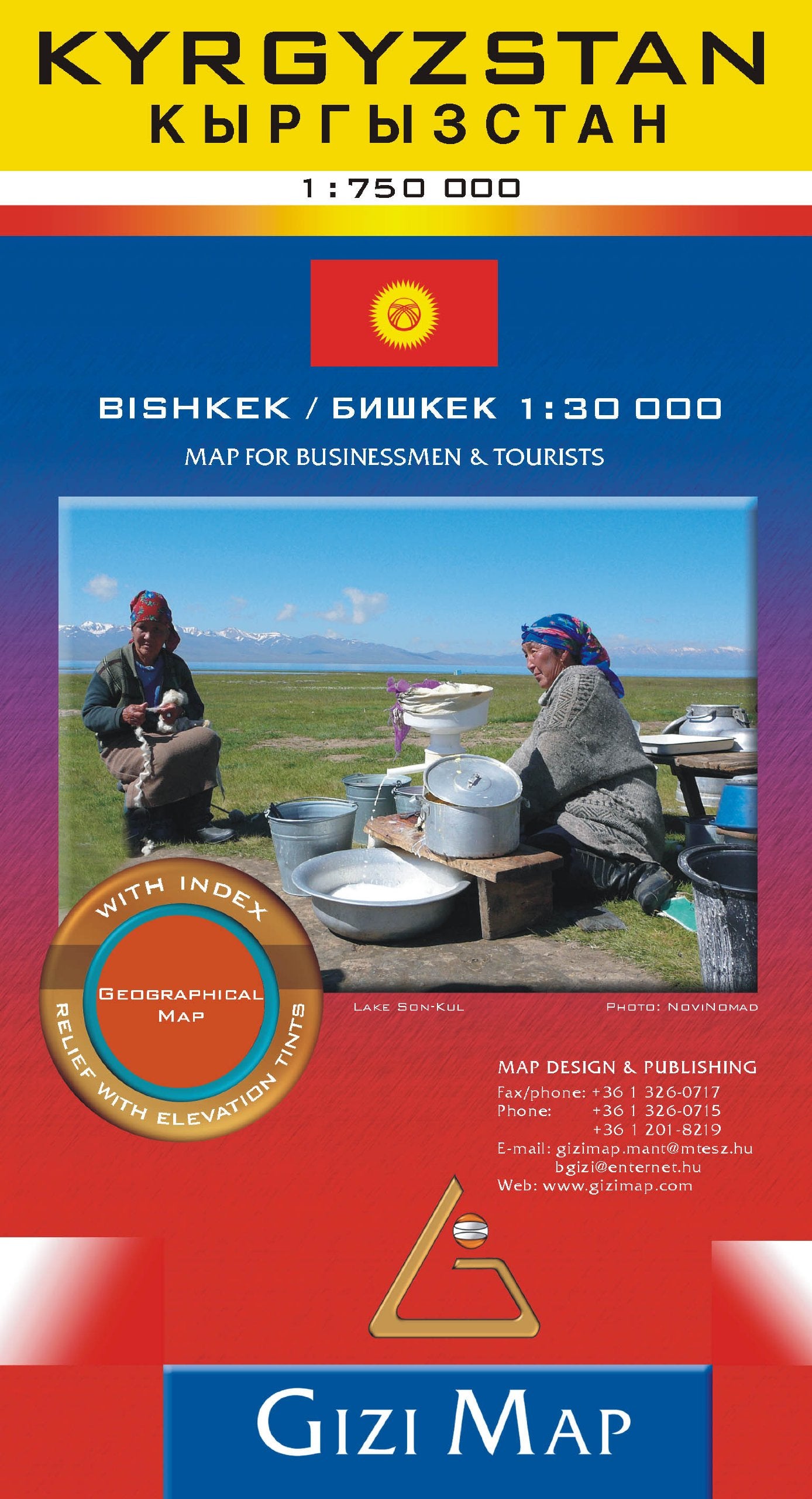
Kyrgistan Gizi Maps Folded
$29.95
Afterpay is only available for orders between $50.00 and $1000.00 More info
Detailed Road & Terrain Map | Scale 1:750,000 | Single-Sided | Order on Demand
Venture into the heart of Central Asia with the Kyrgyzstan Folded Map by Gizi Maps—a beautifully rendered and highly practical navigation aid for anyone exploring this stunning mountainous nation. Designed at a generous scale of 1:750,000, this map gives you an excellent overview of the entire country while maintaining enough detail for route planning, trekking, and cultural travel.
From the shores of Lake Issyk-Kul to the rugged heights of the Tien Shan Mountains, this map puts all of Kyrgyzstan’s scenic wonders at your fingertips.
✅ Highlights at a Glance
| 🧭 Feature | ✅ Description |
|---|---|
| Map Type | Single-sided, folded road and terrain map |
| Scale | 1:750,000 – excellent for regional and national travel |
| Topographic Relief | Colour shading shows elevation and terrain detail |
| Points of Interest | National parks, archaeological sites, UNESCO sites, caravanserais, and more |
| Road Network | Primary, secondary, and rural roads with distances marked |
| Tourism Symbols | Hot springs, hiking areas, cultural monuments, religious sites |
| Index | Extensive place name index with towns, cities, and geographic landmarks |
| City Insets | Key towns and transport hubs clearly labeled |
| Map Dimensions | 1000 mm x 930 mm (approx. 39 x 36.5 in) |
| Publisher | Gizi Maps – known for their clarity, accuracy, and design quality |
| Edition | Latest available edition |
| Languages | Multilingual (local names, international-friendly notation) |
📌 What Makes This Map Special?
-
Adventure-Ready Design: Rugged enough to guide mountaineers, hikers, and off-road adventurers, this map is also perfect for cultural explorers tracing Silk Road heritage routes through Kyrgyzstan’s ancient settlements and alpine valleys.
-
Colour Elevation Relief: The physical geography of Kyrgyzstan is vividly brought to life with gradient shading that reveals the region's varied terrain—from fertile valleys and highland pastures to snow-capped peaks and desert margins.
-
Tourist-Friendly Features: Includes detailed information on parks such as Ala-Archa National Park, Sary-Chelek, and Tash Rabat, plus historic trade routes, yurt camps, ski areas, and other must-see locations.
-
Accurate Distances & Road Info: Ideal for road trips or overland expeditions—distance markers between towns and fuel station locations make this a practical choice for self-guided travellers.
📦 Format & Delivery
-
Folded Map Format – Compact and travel-ready, fits in backpacks or glove compartments.
-
Printed on premium map paper – Durable and crisp.
-
Order on Demand – Please allow up to 10 working days for delivery as this title is printed to order to ensure accuracy and quality.
🧳 Ideal For:
-
🧭 Adventure travellers planning treks or mountain crossings
-
📚 Educators and researchers seeking detailed topographic and geographic insight
-
🌍 Cultural explorers tracing nomadic routes and Silk Road history
-
🚙 Overlanders and road trippers needing up-to-date road detail
-
🏞️ Nature lovers visiting Kyrgyzstan’s parks, valleys, and remote mountain lakes
Unfold the beauty, complexity, and adventure of Kyrgyzstan—one of the last great wildernesses of the Silk Road—with this superbly designed Gizi Maps edition.
Frequently Asked Questions
Where can I buy the Kyrgistan Gizi Maps Folded?
The Kyrgistan Gizi Maps Folded is available to buy online from Mapworld, Australia's largest map and geographic product retailer, with fast shipping Australia-wide.
Is the Kyrgistan Gizi Maps Folded in stock at Mapworld?
Mapworld maintains extensive stock across its map range and aims for fast dispatch. Orders placed before 2pm AEST on business days are typically dispatched the same day, with standard and express Australia-wide delivery options available.
What is Mapworld's returns policy?
Mapworld accepts returns on undamaged items in original condition. Contact Mapworld within 90 days of purchase to arrange a return or exchange.
Does Mapworld ship the Kyrgistan Gizi Maps Folded across Australia?
Yes, Mapworld ships Australia-wide. Standard shipping is a flat $7 rate, with free standard shipping on orders over $75. Express options are available at checkout. Most orders placed before 2pm AEST on weekdays are dispatched same day.
Related Items

© 2026 Mapworld. Website designed by Genie Media
X