- Australia ▾
- Topographic
▾
- Australia AUSTopo 250k (2025)
- Australia 50k Geoscience maps
- Australia 100k Geoscience maps
- Australia 250k Geoscience maps
- Australia 1:1m Geoscience maps
- New Zealand 50k maps
- New Zealand 250k maps
- New South Wales 25k maps
- New South Wales 50k maps
- New South Wales 100k maps
- Queensland 10k maps
- Queensland 25k maps
- Queensland 50k maps
- Queensland 100k maps
- Western Australia 25k maps
- Western Australia 50k maps
- Western Australia 100k maps
- Compasses
- Software
- GPS Systems
- International ▾
- Wall Maps
▾
- World
- Australia & New Zealand
- Countries, Continents & Regions
- Historical
- Vintage National Geographic
- Australian Capital Territory
- New South Wales
- Northern Territory
- Queensland
- South Australia
- Tasmania
- Victoria
- Western Australia
- Celestial
- Children's
- Mining & Resources
- Wine Maps
- Healthcare
- Postcode Maps
- Electoral Maps
- Nautical ▾
- Flags
▾
- Australian Flag Sets & Banners
- Flag Bunting
- Handwavers
- Australian National Flags
- Aboriginal Flags
- Torres Strait Islander Flags
- International Flags
- Flagpoles & Accessories
- Australian Capital Territory Flags
- New South Wales Flags
- Northern Territory Flags
- Queensland Flags
- South Australia Flags
- Tasmania Flags
- Victoria Flags
- Western Australia Flags
- Gifts ▾
- Globes ▾
Dear valued customer. Please note that our checkout is not supported by old browsers. Please use a recent browser to access all checkout capabilities


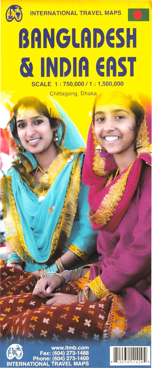
Bangladesh & India East ITMB Map
$24.95
Afterpay is only available for orders between $50.00 and $1000.00 More info
Double-Sided | Includes Inset of Dhaka | Optional Lamination
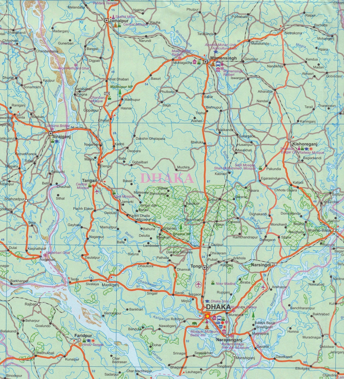
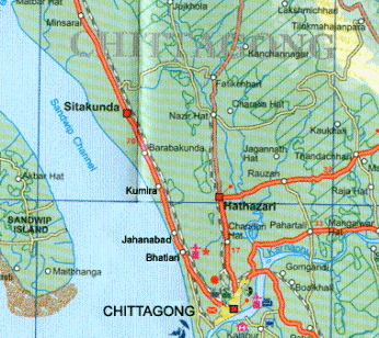
Explore one of South Asia's most intriguing and culturally rich regions with this double-sided travel map by ITMB, covering all of Bangladesh and the easternmost states of India. Designed for independent travellers, educators, researchers, and tour operators, this map offers detailed topographical and road information—ideal for planning overland routes, cross-border exploration, and cultural tours.
🗺️ Map Coverage
Side 1: Bangladesh (Scale 1:750,000)
-
Full-country coverage, from Chittagong Hill Tracts to the Sundarbans
-
Inset map of Dhaka, the capital city
-
Major cities: Khulna, Rajshahi, Sylhet, Cox’s Bazar
-
Highlighted ferry routes, including the Dhaka to Khulna journey—one of the most iconic river trips in Asia
-
Points of interest including UNESCO World Heritage sites, national parks, and historic mosques
Side 2: Eastern India (Scale 1:1,500,000)
-
Covers India’s northeastern states adjoining Bangladesh:
-
West Bengal, Assam, Meghalaya, Tripura, Nagaland, and Manipur
-
-
Major access routes, highways, and cross-border connections
-
Tourist and cultural highlights, including Kolkata, Darjeeling, Shillong, and more
-
Perfect for planning journeys that traverse both Bangladesh and Eastern India
🔍 Key Features
-
✅ Double-sided layout for efficient regional planning
-
🕌 Includes inset map of Dhaka, the capital of Bangladesh
-
🌍 Features national borders, provincial divisions, towns, rivers, and topographical features
-
⛴️ Highlights major ferry and river transport routes
-
🛤️ Road networks with clear hierarchy of highways, regional roads, and minor tracks
-
🕌 Cultural and heritage markers including temples, mosques, and natural reserves
🔒 Optional Lamination Upgrade
✔️ Enhance your map with professional-grade lamination:
-
Use whiteboard markers to plan routes or annotate travel notes
-
Apply and remove map dots or stickers without damaging the surface
-
Waterproof, tear-resistant, and protected against stains and wear
-
Great for field use, classrooms, and frequent travellers
Note: Lamination is done using 80-micron encapsulation after flattening the original folded map. Slight fold lines may still be visible beneath the laminate.
📐 Product Specifications
| Feature | Details |
|---|---|
| Title | Bangladesh & India East ITMB Map |
| Publisher | International Travel Maps (ITMB) |
| Map Type | Double-sided, folded map |
| Laminated Option | Yes – Durable & writeable |
| Scales | 1:750,000 (Bangladesh) / 1:1,500,000 (Eastern India) |
| Inset | Dhaka city map |
| Sheet Size (Flat) | 680 mm (w) x 990 mm (h) |
| Material | Paper or Laminated (Optional) |
🧳 Perfect For:
-
Travellers exploring Bangladesh and India’s northeast corridor
-
Tour planners and overland adventurers crossing from Kolkata to Dhaka
-
Academic or NGO professionals working in South Asia
-
Classrooms and cultural institutions teaching subcontinental geography
-
Mapping ferry routes and cultural landmarks from the Sundarbans to Shillong
Immerse yourself in the rivers, temples, forests, and historical layers of Eastern South Asia with this richly detailed and practical map.
Frequently Asked Questions
Where can I buy the Bangladesh & India East ITMB Map?
The Bangladesh & India East ITMB Map is available to buy online from Mapworld, Australia's largest map and geographic product retailer, with fast shipping Australia-wide.
Is the Bangladesh & India East ITMB Map in stock at Mapworld?
Mapworld maintains extensive stock across its map range and aims for fast dispatch. Orders placed before 2pm AEST on business days are typically dispatched the same day, with standard and express Australia-wide delivery options available.
What is Mapworld's returns policy?
Mapworld accepts returns on undamaged items in original condition. Contact Mapworld within 90 days of purchase to arrange a return or exchange.
Does Mapworld ship the Bangladesh & India East ITMB Map across Australia?
Yes, Mapworld ships Australia-wide. Standard shipping is a flat $7 rate, with free standard shipping on orders over $75. Express options are available at checkout. Most orders placed before 2pm AEST on weekdays are dispatched same day.
Related Items

© 2026 Mapworld. Website designed by Genie Media
X