Whitsunday Admiralty Chart — Wall Map (1951)
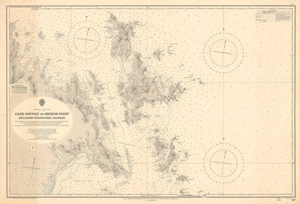
Trade winds, coral blues and white-sand arcs—this 1951 Admiralty chart gathers the Whitsunday Islands and surrounding passages into a single, sea-breathed portrait. Soundings stitch the seafloor into view; reefs and shoals stand crisp against deep water; anchorages, beacons and channels read with calm, nautical authority. Part chart, part keepsake, it brings Australia’s favourite cruising ground onto your wall—clean, confident and quietly irresistible.
Why it captivates
-
Authentic Admiralty pedigree (1951) — a classic hydrographic view of the Whitsundays in precise mid-century drafting.
-
Made for mariners, perfect for interiors — soundings, hazards and navigation notes rendered with legible, timeless elegance.
-
Whitsunday sense of place — passages, bays and island silhouettes set in restrained lettering that reads beautifully from across the room.
-
Scholarly & beautiful — a working document that doubles as a refined statement piece.
What you’ll see
-
Soundings (sounding depths), reefs & shoals, island outlines, bays & passages laid out with Admiralty clarity.
-
Navigation aids—beacons, lights, channels and annotations that map how mariners read the water.
-
Tidal and coastal cues that give the chart its lived, nautical intelligence.
-
Period finish preserved—title block, neatline and calm typographic hierarchy.
A richer historical frame
By 1951, the Whitsundays were already etched into the sailing imagination—reef-sheltered waters, steady trades, reliable anchorages. Admiralty charting distilled that knowledge into exact linework and measured depth, recording a maritime landscape that still feels immediate today. As décor, the chart keeps its purpose: a quiet ledger of seamanship and place.
Choose your finish
Heavyweight Paper (160 gsm matte)
Best for: framing under glass in living rooms and studies
Look & feel: non-glare matte that preserves fine linework and small labels
Laminated (true encapsulation)
Best for: boathouses, classrooms, offices and shared spaces
Build: sealed edge-to-edge between two 80-micron gloss sheets
Benefit: wipe-clean, durable, moisture-resistant
Laminated + Timber Hang Rails (Ready to hang)
What you get: encapsulated print plus natural lacquered timber rails top & bottom with a discreet hanging cord
Where it shines: foyers, yacht clubs, libraries—polished look with everyday toughness
Install: arrives ready to hang (just add a wall hook)
Lead time: please allow up to 10 working days for professional rail mounting
Archival Canvas (395 gsm HP Professional Matte)
Best for: premium interiors, galleries, boardrooms
Print system: pigment-based, fade-resistant inks for long display life
Presence: textured surface adds warmth and museum-style depth
Canvas + Timber Hang Rails (Gallery-ready)
What you get: canvas fitted with natural timber rails top & bottom, matching cord
Where it shines: statement walls, curated coastal spaces, heritage displays
Install: ready to hang; single-hook friendly
Lead time: please allow up to 10 working days for rail mounting
Sizes (W × H)
-
1000 × 680 mm — balanced landscape format with generous hydrographic detail
At-a-glance materials
| Option | Best for | Key benefits |
|---|---|---|
| Paper (160 gsm) | Framing under glass | Matte clarity; crisp chart detail |
| Laminated (encapsulated) | Busy/shared spaces | Wipeable; tough; edge-to-edge protection |
| Laminated + Rails | Ready-to-hang public display | Professional mount; easy install; durable |
| Canvas (395 gsm) | Premium display | Archival inks; textured depth; gallery appeal |
| Canvas + Rails | Gallery-ready feature | Period-true presentation; simple hanging |
Styling ideas
-
Coastal gallery wall: pair with a brass picture light and a small caption card noting favourite anchorages.
-
Yacht club or marina foyer: choose Laminated + Rails for a robust, polished display.
-
Home study or lounge: canvas with rails above timber cabinetry for warm, nautical calm.
-
Travel nook: frame the paper edition with a compass and vintage chart dividers.
Specifications
| Detail | Description |
|---|---|
| Title | Whitsunday Admiralty Chart — Wall Map |
| Edition | 1951 |
| Region | Whitsunday Islands and surrounding passages, Queensland |
| Type | Admiralty hydrographic chart (decorative reproduction) |
| Content Highlights | Soundings; reefs & shoals; channels; lights & beacons; bays & passages; period lettering & neatline |
| Finishes | Paper; Laminated (encapsulated); Laminated + Timber Rails; Canvas; Canvas + Timber Rails |
| Lead Time (Rails) | Up to 10 working days (laminated or canvas with rails) |
| Orientation | Landscape |
| Size | 1000 × 680 mm (W × H) |
| Production | Made in Australia |
Who it’s for
-
Sailors, cruisers and island-lovers with Whitsunday ties
-
Yacht clubs, marinas & coastal venues curating nautical heritage
-
Collectors & interior designers seeking authentic mid-century chart aesthetics
Claim your wall. Choose Paper for crisp, frame-ready clarity. Go Laminated + Timber Rails for tough, ready-to-hang polish. Step up to Archival Canvas + Timber Hang Rails for gallery weight. Printed in Australia with pigment-based, fade-resistant inks. Built to last. Hang it. Live with it. Keep the sea close.


