Up-to-Date Map of the World War — Manila Shinbun-sha (1942)
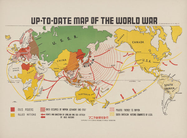
Sea lanes, air routes and front lines—this 1942 wartime wall map by Manila Shinbun-sha gathers a world in motion onto one commanding sheet. Continents carry the weight of shifting theatres; oceans are threaded with routes and arrows; bases and strongpoints anchor the page. Part briefing, part time capsule, it brings the global scale of the conflict into clear, room-length focus—measured, informative, and unmistakably of its moment.
Why it captivates
-
Global theatre at a glance — a single sheet that relates Europe, the Pacific, Asia and the Atlantic in one readable frame.
-
Wartime symbology — fronts, routes and key locations rendered in a clear operational language of the period.
-
Historical fidelity (1942) — borders, names and balances shown as they were understood in the middle years of WWII.
-
Scholarly & display-ready — the calm discipline of a reference map with the presence of a vintage poster.
What you’ll see
-
Theatres of operation set across Europe, North Africa, the Pacific and Asia, with connecting sea and air routes.
-
Key cities, ports, canals and straits that explain movement and logistics at a glance.
-
Wartime notations & legends identifying fronts, bases and lines of communication.
-
Period finish preserved—titlework, neatline and a restrained hierarchy for labels and features.
A richer historical frame
Published in 1942 by Manila Shinbun-sha, this map condenses a rapidly changing war into evidence arranged with care: routes, fronts and strategic hubs placed against geography to aid public understanding. Seen today, it reads as both a practical brief and a historical artefact—an intact view from the middle of the story.
Choose your finish
Heavyweight Paper (160 gsm matte)
Best for: framing under glass in studies, libraries and classrooms
Look & feel: non-glare matte that preserves fine linework and small labels
Laminated (true encapsulation)
Best for: schools, museums, offices and shared spaces
Build: sealed edge-to-edge between two 80-micron gloss sheets
Benefit: wipe-clean, durable, moisture-resistant with a gloss that helps reduce fading
Laminated + Timber Hang Rails (Ready to hang)
What you get: encapsulated print plus natural lacquered timber rails top & bottom with a discreet hanging cord
Where it shines: foyers, lecture rooms, reading rooms—polished look with everyday toughness
Install: arrives ready to hang (just add a wall hook)
Lead time: please allow up to 10 working days for professional rail mounting
Archival Canvas (395 gsm HP Professional Matte)
Best for: premium interiors, galleries and boardrooms
Print system: pigment-based, fade-resistant inks for long display life
Presence: textured surface adds warmth and museum-style depth
Canvas + Timber Hang Rails (Gallery-ready)
What you get: canvas fitted with natural timber rails top & bottom, matching cord
Where it shines: statement walls, curated wartime displays, heritage spaces
Install: ready to hang; single-hook friendly
Lead time: please allow up to 10 working days for rail mounting
Size (W × H)
-
841 × 623 mm — generous landscape format with strong global readability
At-a-glance materials
| Option | Best for | Key benefits |
|---|---|---|
| Paper (160 gsm) | Framing under glass | Matte clarity; crisp period detail |
| Laminated (encapsulated) | Busy/shared spaces | Wipeable; tough; UV-filtering gloss |
| Laminated + Rails | Ready-to-hang display | Professional mount; easy install; durable |
| Canvas (395 gsm) | Premium display | Archival inks; textured depth; gallery appeal |
| Canvas + Rails | Gallery-ready feature | Period-true presentation; simple hanging |
Styling ideas
-
Study wall: frame the paper edition; add a caption card noting family service or key dates.
-
Learning space: choose Laminated + Rails for durable, hands-on teaching.
-
Exhibition cluster: canvas with rails beside period photographs or newspapers for context.
-
Office or library: place above timber cabinetry; keep a magnifier handy for route detail.
Specifications
| Detail | Description |
|---|---|
| Title | Up-to-Date Map of the World War — Manila Shinbun-sha |
| Edition | 1942 |
| Publisher | Manila Shinbun-sha |
| Type | Wartime world reference map |
| Content Highlights | Theatres of operation; fronts; sea & air routes; key ports & straits; period legends & neatline |
| Finishes | Paper; Laminated (encapsulated); Laminated + Timber Rails; Canvas; Canvas + Timber Rails |
| Lead Time (Rails) | Up to 10 working days (laminated or canvas with rails) |
| Orientation | Landscape |
| Size | 841 × 623 mm (W × H) |
| Production | Made in Australia |
Who it’s for
-
Historians, educators & libraries teaching global WWII geography
-
Families and collectors preserving wartime stories
-
Interior designers seeking a striking, documentary map with vintage authority
Claim your wall. Choose Paper for crisp, frame-ready clarity. Go Laminated + Timber Rails for tough, ready-to-hang polish. Step up to Archival Canvas + Timber Hang Rails for gallery weight. Printed in Australia with pigment-based, fade-resistant inks. Built to last. Hang it. Live with it. Keep the story in view.


