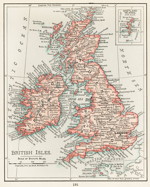
A Turn-of-the-Century Portrait — British Isles (1900), Universal Atlas of the World
Stand at the threshold of a new century and watch the British Isles come into focus. Published in 1900 for the Universal Atlas of the World, this elegant cartographic portrait gathers coasts and counties, principal cities, railways and sea lanes into a clear, confident view of Britain and Ireland—Victorian solidity meeting modern momentum. It’s a beautifully balanced snapshot of geography, infrastructure, and identity at the dawn of the twentieth century.
More Than a Map – A Testament to History
This is not just wall art—it’s a classroom on a single sheet. Every boundary, placename, and transport link reveals how people moved, traded, and imagined the Isles in 1900. Ideal for historians, educators, genealogists, designers, collectors, and Anglophiles, this map is both a visual treasure and a rigorous teaching tool.
Display it in classrooms, offices, museums, libraries, or your home, and create a space that invites reflection, study, and conversation.
Premium Materials & Finishes
We treat history with the respect it deserves. That’s why we offer multiple formats, each produced using the highest quality materials and modern archival printing techniques.
🌟 Archival Paper Print
Printed on heavyweight 160gsm archival-grade paper.
Smooth matte finish that reduces glare and preserves fine boundary work, coastline hatching, and typography.
Ideal for framing under glass, showcasing period detail with sophisticated clarity.
💎 Laminated Edition
Encapsulated in two 80-micron gloss laminate sheets using true thermal bonding—not just surface lamination.
Moisture-resistant, wipe-clean surface—perfect for schools, offices, and high-traffic spaces.
Optional Natural Timber Hang Rails: lacquered rails add a polished, classic look. With a fitted hanging cord, your laminated map is ready to display—no frame required. (Please allow up to 10 working days for delivery with hang rails.)
🏆 Museum-Quality Canvas
Printed on heavyweight 395gsm HP Professional Matte Canvas, chosen for rich texture and exceptional strength.
Pigment-based, fade-resistant inks produce vibrant colour and crisp linework that endure for generations.
Optional Natural Timber Hang Rails: lacquered to enhance the wood grain and protect against wear, with a top cord for effortless hanging—timeless and elegant in any setting. (Please allow up to 10 working days for delivery with hang rails.)
Specifications
| Feature | Details |
|---|---|
| Original Publication | 1900, Universal Atlas of the World |
| Title | Cartographic Map of the British Isles |
| Map Size | 801 mm (W) × 1000 mm (H) |
| Available Formats | Paper, Laminated, Canvas |
| Paper Weight | 160gsm archival-quality |
| Laminate | 2 × 80-micron gloss laminate sheets (encapsulated) |
| Canvas Weight | 395gsm HP Professional Matte Canvas |
| Inks | Pigment-based, fade-resistant |
| Optional Hang Rails | Available on Laminated & Canvas versions |
| Origin | Made in Australia |
Why Choose This Map
✔ A Century’s Threshold: Britain and Ireland as 1900 arranged them—clear, comparative, and complete.
✔ Study-Ready Clarity: Calm typography and precise engraving reward close reading and display beautifully from across the room.
✔ Decorative & Scholarly: Equally suited to interiors and to teaching history, geography, and family heritage.
✔ Crafted to Last: Premium substrates and archival inks keep colour and detail true for decades.
✔ Ready to Display: Optional hang-railed laminated or canvas editions provide a museum-quality presentation—no frame required.
✔ A Meaningful Gift: Perfect for historians, teachers, travellers, genealogists, and design-minded collectors.
Our Commitment
We believe that preserving history is as important as telling it. Every map is printed locally in Australia using state-of-the-art technology, carefully checked by hand, and packed with care. From the moment it leaves our workshop to the day it hangs on your wall, we ensure quality you can trust and a legacy you’ll be proud to share.
Bring the Isles into focus at a defining moment. Order the British Isles map from the Universal Atlas of the World (1900) today—a faithful, beautifully produced record of place, connection, and change.


