- Australia ▾
- Topographic
▾
- Australia AUSTopo 250k (2025)
- Australia 50k Geoscience maps
- Australia 100k Geoscience maps
- Australia 250k Geoscience maps
- Australia 1:1m Geoscience maps
- New Zealand 50k maps
- New Zealand 250k maps
- New South Wales 25k maps
- New South Wales 50k maps
- New South Wales 100k maps
- Queensland 10k maps
- Queensland 25k maps
- Queensland 50k maps
- Queensland 100k maps
- Western Australia 25k maps
- Western Australia 50k maps
- Western Australia 100k maps
- Compasses
- Software
- GPS Systems
- International ▾
- Wall Maps
▾
- World
- Australia & New Zealand
- Countries, Continents & Regions
- Historical
- Vintage National Geographic
- Australian Capital Territory
- New South Wales
- Northern Territory
- Queensland
- South Australia
- Tasmania
- Victoria
- Western Australia
- Celestial
- Children's
- Mining & Resources
- Wine Maps
- Healthcare
- Postcode Maps
- Electoral Maps
- Nautical ▾
- Flags
▾
- Australian Flag Sets & Banners
- Flag Bunting
- Handwavers
- Australian National Flags
- Aboriginal Flags
- Torres Strait Islander Flags
- International Flags
- Flagpoles & Accessories
- Australian Capital Territory Flags
- New South Wales Flags
- Northern Territory Flags
- Queensland Flags
- South Australia Flags
- Tasmania Flags
- Victoria Flags
- Western Australia Flags
- Gifts ▾
- Globes ▾
Dear valued customer. Please note that our checkout is not supported by old browsers. Please use a recent browser to access all checkout capabilities


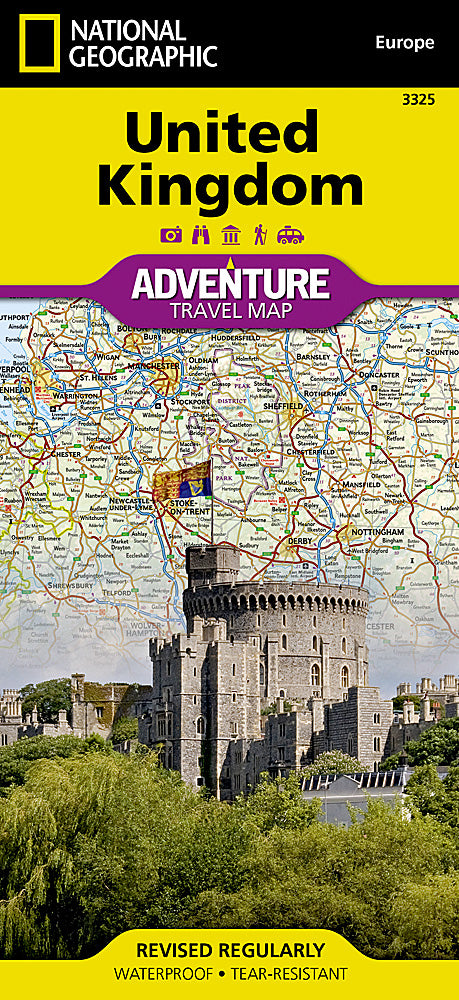
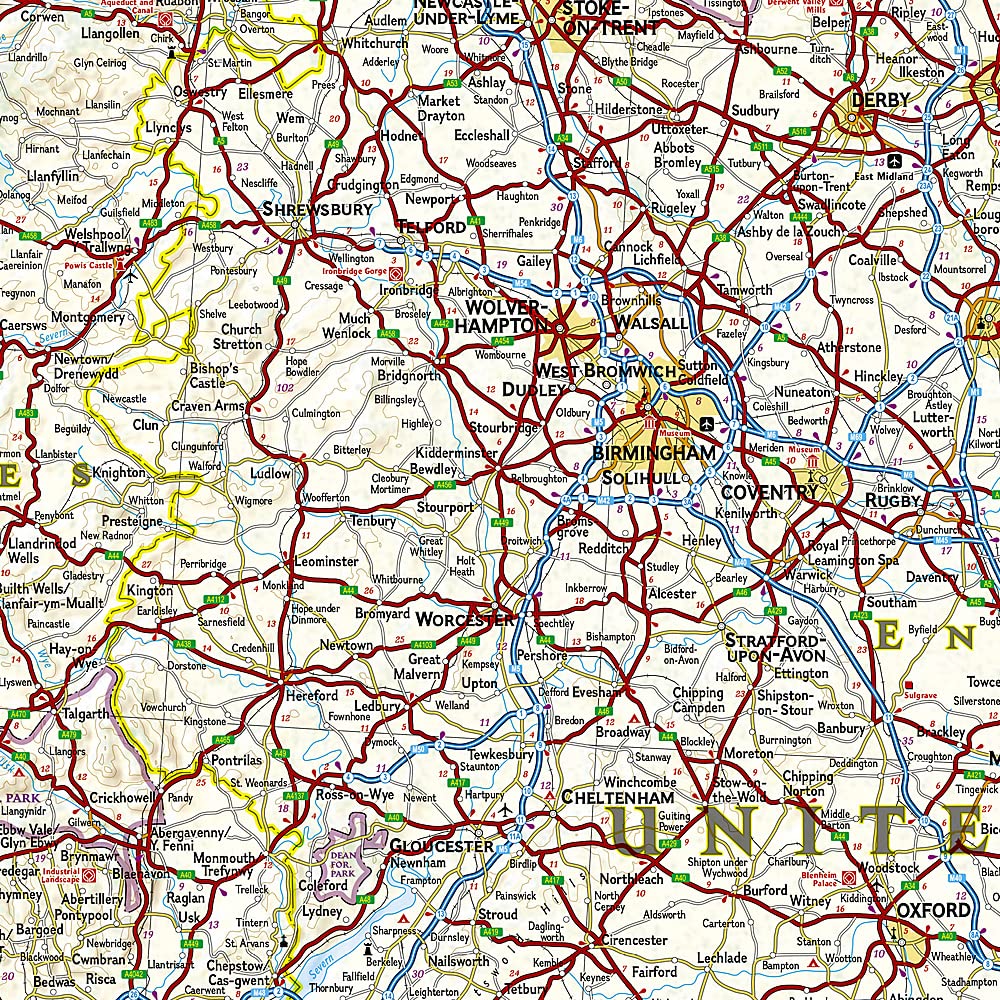
United Kingdom National Geographic Folded Map
$27.95
Afterpay is only available for orders between $50.00 and $1000.00 More info
Double-Sided Folded Travel Map | Waterproof & Tear-Resistant Synthetic Paper
Scale: 1:825,000 | Sheet Size: 959 mm x 648 mm | Folded Size: 235 mm x 108 mm
🇬🇧 Discover the Full Beauty of the United Kingdom with National Geographic Precision
From rolling English countryside and dramatic Scottish Highlands to the windswept coasts of Wales and the cultural richness of Northern Ireland, the United Kingdom Adventure Map by National Geographic offers an exceptional blend of accuracy, detail, and durability. Whether you're planning a road trip through England, a trek across Snowdonia, or an exploration of historic sites from Edinburgh to Belfast, this map is the perfect companion for adventure travellers and culturally curious explorers alike.
Carefully designed with motorists, hikers, and explorers in mind, the map highlights hundreds of recreational, ecological, and historical points of interest, helping you go beyond the typical guidebook.
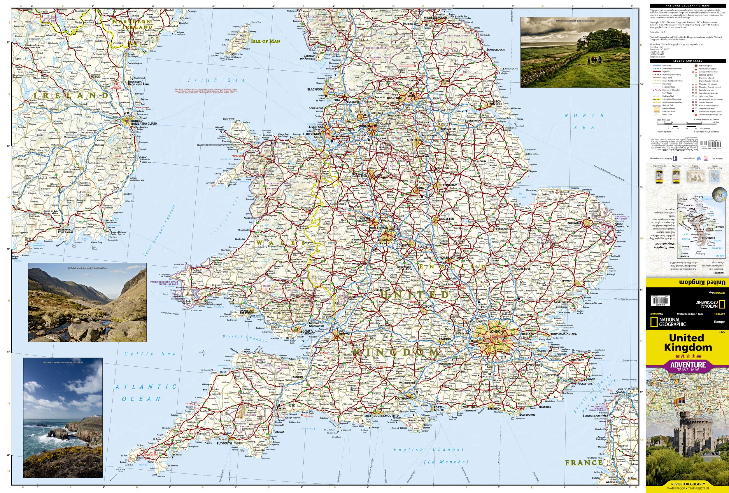
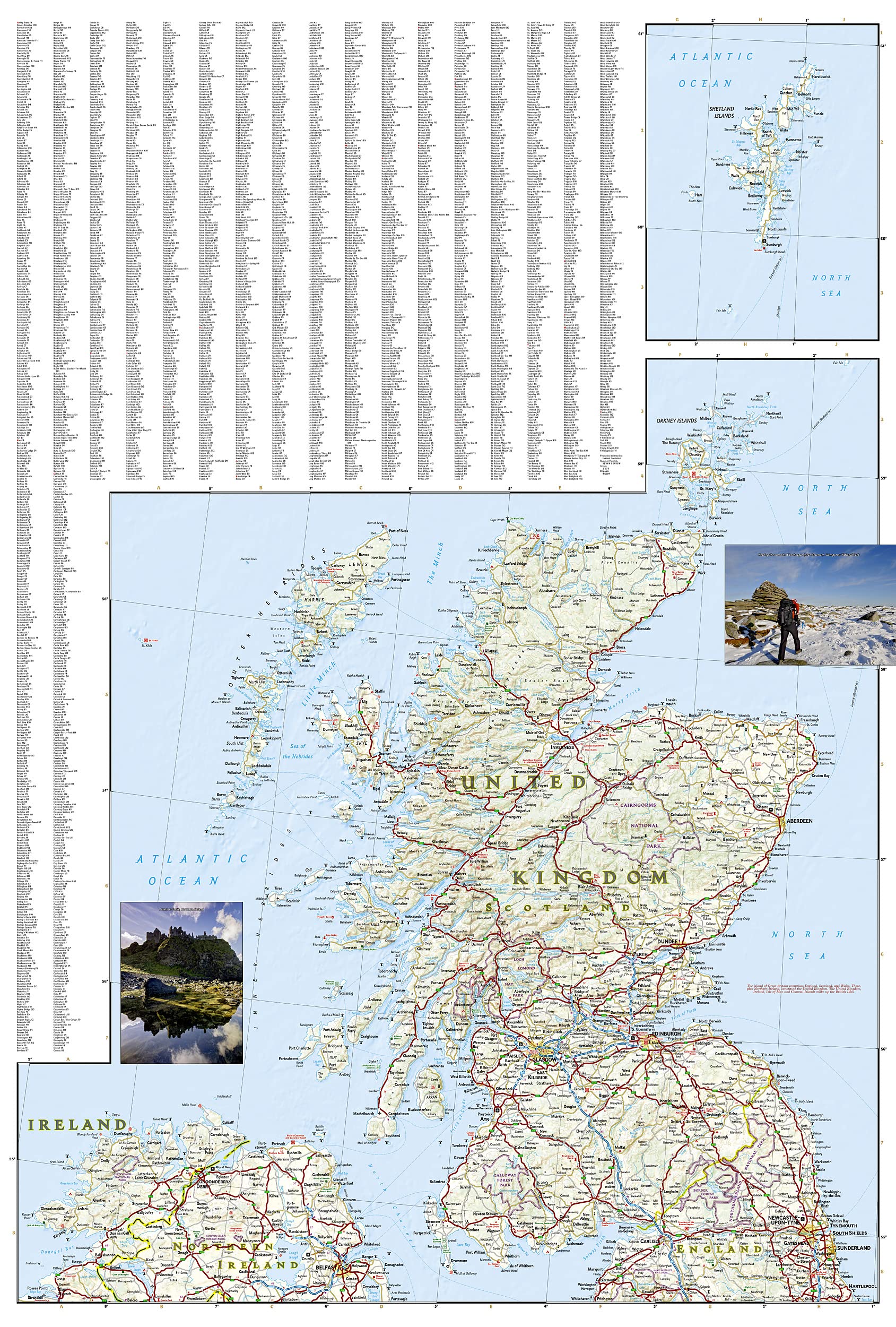
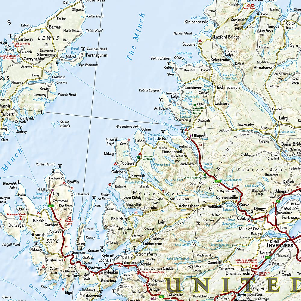
🧭 Regional Coverage – Two Maps in One
🗺 Side 1 – Southern UK & Ireland
-
Covers Southern England, Wales, the Isle of Man, and Southern Ireland, extending from the English Channel to the Irish Sea
-
Shows key cities and destinations including London, Oxford, Bath, Cardiff, Dublin, and Belfast
-
Perfect for planning scenic drives, coastal walks, or castle tours
🗺 Side 2 – Northern UK & Scottish Isles
-
Extends north from Belfast and Edinburgh to cover:
-
The Scottish Highlands, Loch Ness, Aberdeen, Inverness
-
Island regions including the Outer Hebrides, Orkney Islands, and Shetland Islands
-
-
Excellent for rugged, remote adventures and island-hopping itineraries
🧳 Key Features
✅ Comprehensive Road Network
-
Clearly marked motorways, primary roads, secondary routes, and scenic byways
-
Includes kilometre-based distances to support road trip and itinerary planning
-
Ferry routes and channel crossings also included
✅ Topographic and Geographic Detail
-
Highlights major bodies of water such as Lough Neagh, Loch Ness, and coastal inlets
-
Depicts key physical boundaries like Scotland’s Highland Fault Line
-
Elevation shading and geographic contours provide a clear sense of terrain
✅ Cultural, Historical & Recreational Sites
-
Hundreds of points of interest marked, including:
-
🏰 Castles, ruins, cathedrals, and battlefields
-
🌲 National parks, walking paths, and ecological reserves
-
🎭 Museums, heritage towns, and scenic lookouts
-
✅ Built to Last
-
Printed on tear-resistant, waterproof synthetic paper
-
Ideal for frequent folding, outdoor use, and wet-weather travel
-
Lightweight and compact – folds to a convenient, pocketable size
✅ User-Friendly Design
-
Includes comprehensive place name index for quick reference
-
Features clear legend with intuitive map symbols and categories
-
Designed in English with a global traveler in mind
📐 Specifications at a Glance
| Feature | Details |
|---|---|
| Map Type | Folded, double-sided adventure map |
| Publisher | National Geographic Maps |
| Scale | 1:825,000 |
| Sheet Size (Unfolded) | 959 mm x 648 mm (approx. 37.7" x 25.5") |
| Folded Size | 235 mm x 108 mm (approx. 9.25" x 4.25") |
| Material | Waterproof, tear-resistant synthetic paper |
| Language | English (place names, symbols, and index) |
| Topographic Detail | Elevation shading, terrain markers, natural features |
| Index | Includes cities, towns, islands, and major physical features |
👥 Who Is This Map For?
-
🚗 Road trippers and self-guided travellers exploring the UK by car or campervan
-
🧭 Hikers and nature lovers planning routes across the Lake District, Snowdonia, or the Highlands
-
📚 Cultural tourists and history buffs visiting castles, battlefields, and heritage sites
-
🗺️ Map collectors and National Geographic fans looking for beautiful, functional cartography
-
🧳 International visitors seeking a durable, all-in-one guide to British geography
🛒 Add the United Kingdom Adventure Map to Your Cart Today
Perfectly suited for international travel, regional exploration, or educational planning, this rugged yet elegant National Geographic map is your gateway to experiencing the UK in full detail.
Frequently Asked Questions
What area does the United Kingdom National Geographic Folded Map cover?
The United Kingdom National Geographic Folded Map provides road coverage of the region named in the product title. The map covers major cities, highways, towns, and regional roads, with inset city maps for key urban centres where applicable.
Is the United Kingdom National Geographic Folded Map up to date?
Yes, this is the current edition. Mapworld stocks the most current editions from all major publishers, updated to reflect new roads and infrastructure.
What size is this map when unfolded?
Folded maps from Mapworld's range are compact and portable. Most standard folded road or travel maps open to between A1 (594 × 841mm) and A0 (841 × 1189mm) when fully unfolded, and fold down to approximately A4 or smaller for easy storage in a glove box, bag, or backpack.
Is the United Kingdom National Geographic Folded Map in stock at Mapworld?
Mapworld maintains extensive stock across its map range and aims for fast dispatch. Orders placed before 2pm AEST on business days are typically dispatched the same day, with standard and express Australia-wide delivery options available.
Does Mapworld ship the United Kingdom National Geographic Folded Map across Australia?
Yes, Mapworld ships Australia-wide. Standard shipping is a flat $7 rate, with free standard shipping on orders over $75. Express options are available at checkout. Most orders placed before 2pm AEST on weekdays are dispatched same day.
Related Items


© 2026 Mapworld. Website designed by Genie Media
X