- Australia ▾
- Topographic
▾
- Australia AUSTopo 250k (2025)
- Australia 50k Geoscience maps
- Australia 100k Geoscience maps
- Australia 250k Geoscience maps
- Australia 1:1m Geoscience maps
- New Zealand 50k maps
- New Zealand 250k maps
- New South Wales 25k maps
- New South Wales 50k maps
- New South Wales 100k maps
- Queensland 10k maps
- Queensland 25k maps
- Queensland 50k maps
- Queensland 100k maps
- Western Australia 25k maps
- Western Australia 50k maps
- Western Australia 100k maps
- Compasses
- Software
- GPS Systems
- International ▾
- Wall Maps
▾
- World
- Australia & New Zealand
- Countries, Continents & Regions
- Historical
- Vintage National Geographic
- Australian Capital Territory
- New South Wales
- Northern Territory
- Queensland
- South Australia
- Tasmania
- Victoria
- Western Australia
- Celestial
- Children's
- Mining & Resources
- Wine Maps
- Healthcare
- Postcode Maps
- Electoral Maps
- Nautical ▾
- Flags
▾
- Australian Flag Sets & Banners
- Flag Bunting
- Handwavers
- Australian National Flags
- Aboriginal Flags
- Torres Strait Islander Flags
- International Flags
- Flagpoles & Accessories
- Australian Capital Territory Flags
- New South Wales Flags
- Northern Territory Flags
- Queensland Flags
- South Australia Flags
- Tasmania Flags
- Victoria Flags
- Western Australia Flags
- Gifts ▾
- Globes ▾
Dear valued customer. Please note that our checkout is not supported by old browsers. Please use a recent browser to access all checkout capabilities


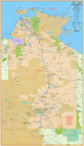
Leasing & Licensing Aboriginal Land - Northern Territory
$69.95
or make 4 interest-free payments of
$17.49 AUD
fortnightly with
![]() More info
More info
A Comprehensive Tenure Map of the Northern Territory
Discover the intricate patchwork of land tenures that shape the Northern Territory. This detailed and authoritative map illustrates the spectrum of tenure types across the Territory, including building leases, crown leases, grazing leases, pastoral leases, mining leases, freehold land, and more.
For professionals working in land management, policy, legal sectors, community advocacy, or education, this map is an invaluable resource—offering a clear, visual guide to the complex landscape of Aboriginal land leasing and licensing across the NT.
Why This Map Matters
In a region where land is central to identity, livelihood, and history, understanding tenure is essential. This map helps you:
✔ Navigate Complexity: See at a glance the varied forms of tenure and their distribution across the Northern Territory.
✔ Support Professional Work: An essential tool for policy makers, lawyers, land councils, educators, and researchers working with Aboriginal land rights and tenure issues.
✔ Facilitate Discussion & Engagement: Perfect for use in workshops, community meetings, offices, classrooms, or public spaces where informed dialogue matters.
Premium Materials & Finishes
We know this isn’t just a map—it’s a resource you rely on and a piece you want to display with pride. That’s why we offer multiple finishes crafted with premium materials and meticulous care:
🌟 Premium Paper Print
-
Printed on heavyweight 160gsm archival-quality paper.
-
Crisp detail and smooth matte finish—perfect for framing under glass and preserving clarity over time.
💎 Laminated Edition
-
Fully encapsulated in two sheets of 80-micron gloss laminate.
-
Provides a durable, moisture-resistant, wipe-clean surface.
-
Ideal for fieldwork, high-traffic spaces, or settings where the map is frequently referenced and handled.
-
Optional natural timber hang rails lacquered in a warm finish with attached hanging cord—ready to hang with ease.
🏆 Museum-Quality Canvas
-
Produced on premium 395gsm HP Professional Matte Canvas using pigment-based, fade-resistant inks.
-
Rich, tactile texture reminiscent of traditional cartography, combined with exceptional colour and line sharpness.
-
Optional natural timber hang rails provide an elegant, contemporary presentation—no need for framing. Simply hook onto the wall and enjoy.
Note: For canvas and laminated versions with hang rails, please allow up to 10 working days for delivery as each is custom-finished by our framer.
Specifications
| Feature | Details |
|---|---|
| Map Title | Leasing & Licensing Aboriginal Land – NT |
| Size | 1000 mm (W) × 715 mm (H) |
| Formats Available | Paper, Laminated, Canvas |
| Paper Weight | 160gsm archival-quality |
| Laminate | 2 × 80-micron gloss laminate sheets |
| Canvas Weight | 395gsm HP Professional Matte Canvas |
| Inks | Pigment-based, fade-resistant |
| Optional Hang Rails | Available on Laminated & Canvas versions |
Perfect For
✔ Policy Makers & Planners: Quickly visualise land tenure for planning, consultation, and analysis.
✔ Land Councils & Community Organisations: Support community meetings and engagement processes with a clear, professional resource.
✔ Educators & Researchers: A vital tool for teaching about Aboriginal land rights and tenure systems in Australia.
✔ Offices & Conference Spaces: Create an informed, authoritative environment with a map that both informs and inspires.
Our Commitment
We’re dedicated to producing maps that don’t just hang on a wall, but support meaningful work and connection to place. From our careful restoration and printing process to our commitment to premium materials and professional finishing, we ensure every map is crafted to last—and ready to be a trusted resource for years to come.
Order yours today and gain clarity, confidence, and a deeper understanding of Aboriginal land leasing and licensing across the Northern Territory—crafted with precision, built to endure, and made to inspire informed conversations.
Frequently Asked Questions
Where can I buy the Leasing & Licensing Aboriginal Land - Northern Territory?
The Leasing & Licensing Aboriginal Land - Northern Territory is available to buy online from Mapworld, Australia's largest map and geographic product retailer, with fast shipping Australia-wide.
Is the Leasing & Licensing Aboriginal Land - Northern Territory in stock at Mapworld?
Mapworld maintains extensive stock across its map range and aims for fast dispatch. Orders placed before 2pm AEST on business days are typically dispatched the same day, with standard and express Australia-wide delivery options available.
What is Mapworld's returns policy?
Mapworld accepts returns on undamaged items in original condition. Contact Mapworld within 90 days of purchase to arrange a return or exchange.
Does Mapworld ship the Leasing & Licensing Aboriginal Land - Northern Territory across Australia?
Yes, Mapworld ships Australia-wide. Standard shipping is a flat $7 rate, with free standard shipping on orders over $75. Express options are available at checkout. Most orders placed before 2pm AEST on weekdays are dispatched same day.
Related Items


© 2026 Mapworld. Website designed by Genie Media
X