- Australia ▾
- Topographic
▾
- Australia AUSTopo 250k (2025)
- Australia 50k Geoscience maps
- Australia 100k Geoscience maps
- Australia 250k Geoscience maps
- Australia 1:1m Geoscience maps
- New Zealand 50k maps
- New Zealand 250k maps
- New South Wales 25k maps
- New South Wales 50k maps
- New South Wales 100k maps
- Queensland 10k maps
- Queensland 25k maps
- Queensland 50k maps
- Queensland 100k maps
- Compasses
- Software
- GPS Systems
- Orienteering
- International ▾
- Wall Maps
▾
- World
- Australia & New Zealand
- Countries, Continents & Regions
- Historical
- Vintage National Geographic
- Australian Capital Territory
- New South Wales
- Northern Territory
- Queensland
- South Australia
- Tasmania
- Victoria
- Western Australia
- Celestial
- Children's
- Mining & Resources
- Wine Maps
- Healthcare
- Postcode Maps
- Electoral Maps
- Nautical ▾
- Flags
▾
- Australian Flag Sets & Banners
- Flag Bunting
- Handwavers
- Australian National Flags
- Aboriginal Flags
- Torres Strait Islander Flags
- International Flags
- Flagpoles & Accessories
- Australian Capital Territory Flags
- New South Wales Flags
- Northern Territory Flags
- Queensland Flags
- South Australia Flags
- Tasmania Flags
- Victoria Flags
- Western Australia Flags
- Gifts ▾
- Globes ▾
Dear valued customer. Please note that our checkout is not supported by old browsers. Please use a recent browser to access all checkout capabilities


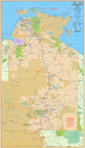
Northern Territory UBD 571 Map 575 x 1000mm Canvas Wall Map
$199.00
or make 4 interest-free payments of
$49.75 AUD
fortnightly with
![]() More info
More info
🏜️ A Rugged Masterpiece of Australia’s Wild North — On Canvas
Bring the beating heart of the Outback into your space with this striking canvas wall map of the Northern Territory, created by UBD Gregory’s, one of Australia’s most trusted cartographic publishers. From the red sands of the Barkly Tableland to the tropical coastline of Darwin and the cultural richness of Arnhem Land, this map is a bold visual journey through one of the world’s most remote and fascinating regions.
Professionally printed on 395 gsm HP Matte Canvas using fade-resistant pigment-based inks, this premium wall map is built to inspire, endure, and inform.
🌏 Key Features & Regional Highlights
| 🗺️ Feature | ✔️ Description |
|---|---|
| Full NT Coverage | From the Tiwi Islands to the Red Centre |
| Highway & Route Mapping | Includes national highways, route numbers, distances |
| Aboriginal Lands | Clearly marked Indigenous territories & cultural zones |
| National Parks | Includes Kakadu, Litchfield, Watarrka, and more |
| Town Index | Full listing of towns with size indicators |
| Visitor Icons | Points of interest, campgrounds, fuel stops, accommodation |
| Marine & Nature Reserves | Identifies protected land and water areas |
| Easy-to-Read Layout | Bold colours, clear fonts, precise road marking |
📍 Perfect for: travel inspiration, trip planning, logistics coordination, or simply admiring the vast beauty of Australia’s Top End.
🖼️ Printed on Premium Canvas
This map is printed on heavy-duty 395 gsm HP Professional Matte Canvas, giving it a tactile, gallery-quality finish. It’s not only highly durable and tear-resistant, but also stunning in any environment:
✅ Fade-resistant pigment-based inks for long-term clarity
✅ Soft matte texture with rich colour saturation
✅ Resistant to moisture and ageing
✅ Easy to roll or frame
🪵 Optional Timber Hang Rails
Upgrade your canvas with an elegant hanging system for instant wall display:
🪵 Natural wooden hang rails — top & bottom
🎗️ Strong cord included — ready to hang from a single hook
🛠️ Smooth lacquer finish — timeless and understated
🔧 Please allow up to 10 business days for the hang rails to be attached by our framer.
📐 Specifications at a Glance
| Specification | Details |
|---|---|
| Title | Northern Territory UBD 571 |
| Map Scale | 1:2,000,000 (state overview) |
| Canvas Size | 575 mm (W) × 1000 mm (H) |
| Material | 395 gsm HP Matte Canvas |
| Print Inks | Fade-resistant pigment inks |
| Printed In | Australia |
| Mounting Options | Canvas only / With timber hang rails |
🎯 Who Is This Map For?
👨💼 Professionals – Use in logistics, education, tourism or planning
🚙 Road-trippers & Caravaners – Plan your NT adventure with detail and style
🏕️ Nature Lovers – Explore the wild richness of Kakadu, Arnhem Land, and more
🎒 Educators – A compelling display for classrooms and libraries
🏡 Home & Office Decorators – Add a ruggedly beautiful centrepiece to any wall
💡 Why Choose This Canvas Map?
✔️ Bold visual impact — Australia’s untamed north, in full detail
✔️ Durability meets beauty — tough enough for planning, beautiful enough to frame
✔️ A statement piece — functional, inspirational, and educational
📦 Ships rolled in a protective tube
⏳ Please allow 10 business days for hang rail orders
Let the Northern Territory's vast, vivid landscapes command your wall. Whether you're dreaming, planning, or reliving an epic journey through the Top End, this UBD Gregory’s canvas wall map is a timeless companion.
Frequently Asked Questions
What are the dimensions of the Northern Territory UBD 571 Map 575 x 1000mm Canvas Wall Map?
Mapworld wall maps range from standard 700×1000mm to large-format 1000×1430mm Supermaps. The exact dimensions for this map are shown in the product title. Where multiple sizes are available, select your preferred size when adding to cart.
Is this wall map available laminated?
Many Mapworld wall maps are available in paper, laminated, or framed finishes. Check the product options when adding to cart. Laminated maps are wipe-clean and more durable.
Is this the latest edition?
Mapworld stocks the most current editions available from all publishers. Edition year is shown in the product title where applicable. Mapworld updates its catalogue as new editions are released.
Can I write on or pin this wall map?
Laminated wall maps can be written on with whiteboard markers and wiped clean. Paper maps can be pinned on a corkboard. Choose a laminated option for a writeable surface.
Does Mapworld ship the Northern Territory UBD 571 Map 575 x 1000mm Canvas Wall Map across Australia?
Yes, Mapworld ships Australia-wide. Standard shipping is a flat $7 rate, with free standard shipping on orders over $75. Express options are available at checkout. Most orders placed before 2pm AEST on weekdays are dispatched same day.
Related Items


© 2026 Mapworld. Website designed by Genie Media
X