- Australia ▾
- Topographic
▾
- Australia AUSTopo 250k (2025)
- Australia 50k Geoscience maps
- Australia 100k Geoscience maps
- Australia 250k Geoscience maps
- Australia 1:1m Geoscience maps
- New Zealand 50k maps
- New Zealand 250k maps
- New South Wales 25k maps
- New South Wales 50k maps
- New South Wales 100k maps
- Queensland 10k maps
- Queensland 25k maps
- Queensland 50k maps
- Queensland 100k maps
- Western Australia 25k maps
- Western Australia 50k maps
- Western Australia 100k maps
- Compasses
- Software
- GPS Systems
- International ▾
- Wall Maps
▾
- World
- Australia & New Zealand
- Countries, Continents & Regions
- Historical
- Vintage National Geographic
- Australian Capital Territory
- New South Wales
- Northern Territory
- Queensland
- South Australia
- Tasmania
- Victoria
- Western Australia
- Celestial
- Children's
- Mining & Resources
- Wine Maps
- Healthcare
- Postcode Maps
- Electoral Maps
- Nautical ▾
- Flags
▾
- Australian Flag Sets & Banners
- Flag Bunting
- Handwavers
- Australian National Flags
- Aboriginal Flags
- Torres Strait Islander Flags
- International Flags
- Flagpoles & Accessories
- Australian Capital Territory Flags
- New South Wales Flags
- Northern Territory Flags
- Queensland Flags
- South Australia Flags
- Tasmania Flags
- Victoria Flags
- Western Australia Flags
- Gifts ▾
- Globes ▾
Dear valued customer. Please note that our checkout is not supported by old browsers. Please use a recent browser to access all checkout capabilities


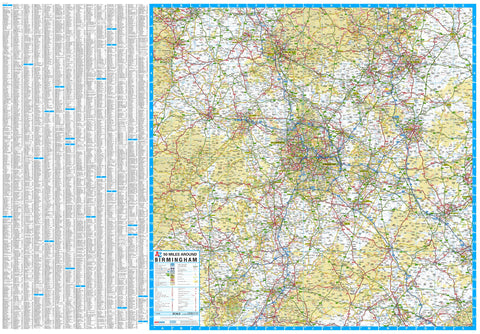
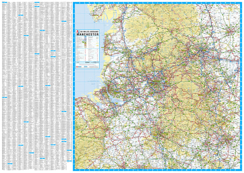
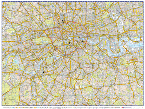
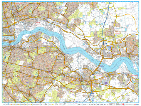
South East & Central England A-Z 1157 x 907mm Wall Map
$69.95
or make 4 interest-free payments of
$17.49 AUD
fortnightly with
![]() More info
More info
A Comprehensive Road Map from Nottingham to the South Coast – Including the Isle of Wight
Experience the full breadth of South East and Central England with this A-Z Wall Map, designed for clarity, coverage, and professional presentation. This large-format, full-colour road map offers continuous mapping from Nottingham in the north to the southern coastline—including the Isle of Wight—and from Cardiff in the west to the east coast.
With bold, easy-to-read cartography and exceptional regional detail, this map is an essential resource for logistics, planning, teaching, or display.
🗺️ Regional Coverage
| 🌍 Direction | 📍 Coverage Highlights |
|---|---|
| North | Nottingham, Leicester, Milton Keynes |
| South | Portsmouth, Brighton, Southampton, Isle of Wight |
| West | Cardiff, Swindon, Reading |
| East | Norwich, Ipswich, Colchester |
| Cities Included | London, Oxford, Birmingham, Cambridge, Cheltenham, Canterbury, Luton |
📌 Key Features
| ✅ Feature | 📋 Details |
|---|---|
| Full Colour Mapping | Easy-to-read roads, towns, rivers, forests, and coastlines |
| Major Routes Highlighted | Clear depiction of motorways and A-roads |
| Postcode Districts | Helpful for service planning and navigation |
| Inset Extension Map | Extends coverage further north to include Berwick-Upon-Tweed, Holy Island, and Seahouses |
| Ideal for Display or Planning | Suitable for business, education, or travel use |
🖼️ Format Options
This wall map is available in five premium formats to suit your display or usage preferences:
| 🖨️ Format | ✨ Description |
|---|---|
| Paper (Unlaminated) | Ideal for framing behind glass or custom mounting |
| Laminated | Gloss-laminated on both sides (80 micron), water-resistant, and writeable with whiteboard markers |
| Laminated with Hang Rails | Laminated map with premium natural timber rails top and bottom, plus hanging cord – ready to display |
| Canvas | Printed on durable 395gsm HP matte canvas using pigment-based fade-resistant inks – a gallery-quality finish |
| Canvas with Wooden Hang Rails | Museum-grade canvas with handcrafted wooden rails (top & bottom) in a natural timber finish – ready to hang |
📐 Specifications
| 🔧 Detail | 📍 Specification |
|---|---|
| Map Title | South East & Central England A-Z Wall Map |
| Publisher | A-Z (Geographers' A-Z Map Company) |
| Edition | 2019 |
| Scale | 1:316,800 |
| Map Size | 1157 mm (W) × 907 mm (H) |
| Print Type | Full-colour, single-sided |
🎯 Who Is This Map For?
| 👤 Audience | 💡 Use Case |
|---|---|
| Businesses & Couriers | Route planning, delivery management, regional logistics |
| Schools & Educators | Geography education, classroom reference |
| Local Government & Utilities | Infrastructure planning, service area mapping |
| Travel & Event Planners | Mapping destinations and itineraries |
| Home & Office Decorators | Adds an elegant and informative feature wall |
💬 Why Choose This Map?
-
✔️ Stunning regional coverage from coast to coast
-
✔️ Clear cartographic style with modern A-Z precision
-
✔️ Multiple format options to suit all uses and interiors
-
✔️ Ideal for anyone working, teaching, or travelling across the South East & Central region of England
🧭 Whether you’re mapping out delivery routes, teaching regional geography, or creating a striking wall feature—this map is a beautiful and practical addition to your space.
Please allow up to 10 working days for delivery of hang-railed maps, as they are custom-mounted by our professional framer.
👉 Choose your preferred finish above and bring the South East & Central England landscape to life.
Frequently Asked Questions
What are the dimensions of the South East & Central England A-Z 1157 x 907mm Wall Map?
Mapworld wall maps range from standard 700×1000mm to large-format 1000×1430mm Supermaps. The exact dimensions for this map are shown in the product title. Where multiple sizes are available, select your preferred size when adding to cart.
Is this wall map available laminated?
Many Mapworld wall maps are available in paper, laminated, or framed finishes. Check the product options when adding to cart. Laminated maps are wipe-clean and more durable.
Is this the latest edition?
Mapworld stocks the most current editions available from all publishers. Edition year is shown in the product title where applicable. Mapworld updates its catalogue as new editions are released.
Can I write on or pin this wall map?
Laminated wall maps can be written on with whiteboard markers and wiped clean. Paper maps can be pinned on a corkboard. Choose a laminated option for a writeable surface.
Does Mapworld ship the South East & Central England A-Z 1157 x 907mm Wall Map across Australia?
Yes, Mapworld ships Australia-wide. Standard shipping is a flat $7 rate, with free standard shipping on orders over $75. Express options are available at checkout. Most orders placed before 2pm AEST on weekdays are dispatched same day.
Related Items
© 2026 Mapworld. Website designed by Genie Media
X