- Australia ▾
- Topographic
▾
- Australia AUSTopo 250k (2025)
- Australia 50k Geoscience maps
- Australia 100k Geoscience maps
- Australia 250k Geoscience maps
- Australia 1:1m Geoscience maps
- New Zealand 50k maps
- New Zealand 250k maps
- New South Wales 25k maps
- New South Wales 50k maps
- New South Wales 100k maps
- Queensland 10k maps
- Queensland 25k maps
- Queensland 50k maps
- Queensland 100k maps
- Western Australia 25k maps
- Western Australia 50k maps
- Western Australia 100k maps
- Compasses
- Software
- GPS Systems
- International ▾
- Wall Maps
▾
- World
- Australia & New Zealand
- Countries, Continents & Regions
- Historical
- Vintage National Geographic
- Australian Capital Territory
- New South Wales
- Northern Territory
- Queensland
- South Australia
- Tasmania
- Victoria
- Western Australia
- Celestial
- Children's
- Mining & Resources
- Wine Maps
- Healthcare
- Postcode Maps
- Electoral Maps
- Nautical ▾
- Flags
▾
- Australian Flag Sets & Banners
- Flag Bunting
- Handwavers
- Australian National Flags
- Aboriginal Flags
- Torres Strait Islander Flags
- International Flags
- Flagpoles & Accessories
- Australian Capital Territory Flags
- New South Wales Flags
- Northern Territory Flags
- Queensland Flags
- South Australia Flags
- Tasmania Flags
- Victoria Flags
- Western Australia Flags
- Gifts ▾
- Globes ▾
Dear valued customer. Please note that our checkout is not supported by old browsers. Please use a recent browser to access all checkout capabilities


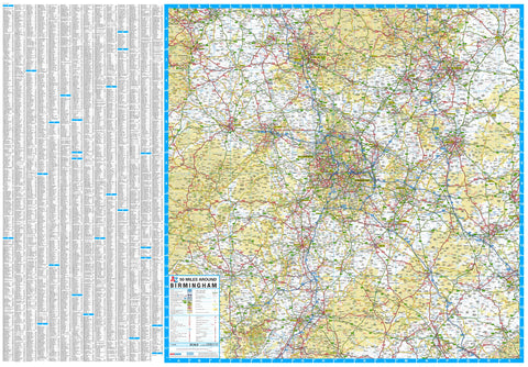
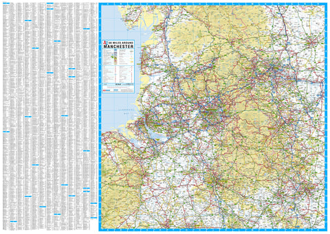
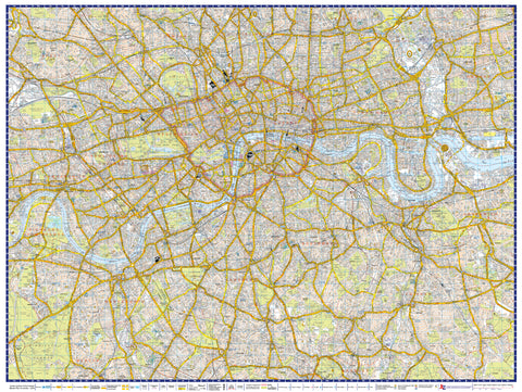
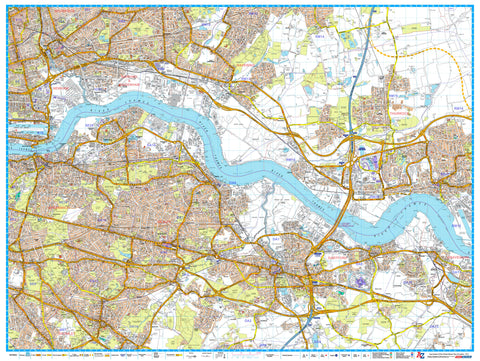
Central England & Wales A-Z 1157 x 907mm Wall Map
$69.95
or make 4 interest-free payments of
$17.49 AUD
fortnightly with
![]() More info
More info
Central England & Wales A-Z Wall Map
Road Map | 1157 x 907 mm | Scale 1:316,800
Published: 2019
Navigate the heart of Britain with confidence and clarity using this detailed A-Z Road Map of Central England and Wales. Spanning the Midlands, southern Northern England, and the entirety of Wales, this vibrant, full-colour wall map brings together A-Z's trusted cartographic heritage with an expansive view of key cities, highways, and rural landscapes.
Whether you're planning logistics routes, regional travel, or simply want a comprehensive wall display of this diverse part of the UK, this map is as functional as it is visually compelling.
🌍 Coverage Area
This map delivers seamless coverage from Bristol and Reading in the south, all the way up to Blackpool and Leeds in the north. From Peterborough in the east, it stretches west to fully encompass the entire country of Wales, making it one of the most comprehensive regional maps in the A-Z series.
Key cities and areas covered include:
-
Birmingham
-
Cardiff
-
Oxford
-
Coventry
-
Swansea
-
Stoke-on-Trent
-
Gloucester
-
Shrewsbury
-
Nottingham
-
Wolverhampton
-
Newport
-
Llandrindod Wells
-
Leicester
-
Wrexham
-
Peterborough
-
And many more...
📐 Specifications
| Attribute | Details |
|---|---|
| Title | Central England & Wales A-Z Map |
| Format | Wall Map (Single-sided) |
| Scale | 1:316,800 |
| Size | 1157 mm (W) x 907 mm (H) |
| Publisher | A-Z Mapping Company |
| Published | 2019 |
🖨️ Format Options
We offer this map in a variety of premium formats to suit your space, purpose, and presentation preference:
-
📄 Paper (160 gsm coated) – Perfect for traditional framing under glass or casual display.
-
🧽 Laminated – Fully encapsulated in 80-micron gloss laminate, making it wipe-clean and suitable for whiteboard markers and our repositionable map dots.
-
🪵 Laminated with Wooden Hang Rails – A display-ready option featuring natural timber hang rails top and bottom, with a secure hanging cord—ideal for office or home.
-
🖼️ Canvas (395 gsm HP Matte Canvas) – Printed using pigment-based inks on heavy-duty canvas, offering a soft, tactile finish with excellent colour retention and durability.
-
🪵 Canvas with Wooden Hang Rails – A premium gallery-style finish, combining timeless canvas texture with solid timber hangers for elegant display.
⏳ Please allow up to 10 working days for delivery of hang-railed versions, as they are individually handcrafted by our professional framer.
🏢 Ideal For:
-
Logistics and regional planning
-
Estate agencies and property developers
-
Business and marketing teams
-
Local councils and government departments
-
Tourism boards and welcome centres
-
Home offices and map enthusiasts
-
Schools and geography departments
🔍 Why Choose This A-Z Map?
✔️ Instant regional overview of the central spine of Britain
✔️ Accurate and trusted mapping from the renowned A-Z cartographers
✔️ Ideal reference for travel, planning, and teaching
✔️ Aesthetic appeal with rich colour and sharp detail
✔️ Custom display options from classic paper to hang-ready canvas
Let the A-Z Central England & Wales Wall Map become a statement piece in your space—uniting function and beauty across one of Britain’s most fascinating regions.
Frequently Asked Questions
What are the dimensions of the Central England & Wales A-Z 1157 x 907mm Wall Map?
Mapworld wall maps range from standard 700×1000mm to large-format 1000×1430mm Supermaps. The exact dimensions for this map are shown in the product title. Where multiple sizes are available, select your preferred size when adding to cart.
Is this wall map available laminated?
Many Mapworld wall maps are available in paper, laminated, or framed finishes. Check the product options when adding to cart. Laminated maps are wipe-clean and more durable.
Is this the latest edition?
Mapworld stocks the most current editions available from all publishers. Edition year is shown in the product title where applicable. Mapworld updates its catalogue as new editions are released.
Can I write on or pin this wall map?
Laminated wall maps can be written on with whiteboard markers and wiped clean. Paper maps can be pinned on a corkboard. Choose a laminated option for a writeable surface.
Does Mapworld ship the Central England & Wales A-Z 1157 x 907mm Wall Map across Australia?
Yes, Mapworld ships Australia-wide. Standard shipping is a flat $7 rate, with free standard shipping on orders over $75. Express options are available at checkout. Most orders placed before 2pm AEST on weekdays are dispatched same day.
Related Items
© 2026 Mapworld. Website designed by Genie Media
X