- Australia ▾
- Topographic
▾
- Australia AUSTopo 250k (2024)
- Australia 50k Geoscience maps
- Australia 100k Geoscience maps
- Australia 250k Geoscience maps
- Australia 1.1m Geoscience maps
- New Zealand 50k maps
- New Zealand 250k maps
- New South Wales 25k maps
- New South Wales 50k maps
- New South Wales 100k maps
- Queensland 10k maps
- Queensland 25k maps
- Queensland 50k maps
- Queensland 100k maps
- Compasses
- Software
- GPS Systems
- Orienteering
- International ▾
- Wall Maps
▾
- World
- Australia & New Zealand
- Countries, Continents & Regions
- Historical
- Vintage National Geographic
- Australian Capital Territory
- New South Wales
- Northern Territory
- Queensland
- South Australia
- Tasmania
- Victoria
- Western Australia
- Celestial
- Children's
- Mining & Resources
- Wine Maps
- Healthcare
- Postcode Maps
- Electoral Maps
- Nautical ▾
- Flags
▾
- Australian Flag Sets & Banners
- Flag Bunting
- Handwavers
- Australian National Flags
- Aboriginal Flags
- Torres Strait Islander Flags
- International Flags
- Flagpoles & Accessories
- Australian Capital Territory Flags
- New South Wales Flags
- Northern Territory Flags
- Queensland Flags
- South Australia Flags
- Tasmania Flags
- Victoria Flags
- Western Australia Flags
- Gifts ▾
- Globes ▾
Dear valued customer. Please note that our checkout is not supported by old browsers. Please use a recent browser to access all checkout capabilities


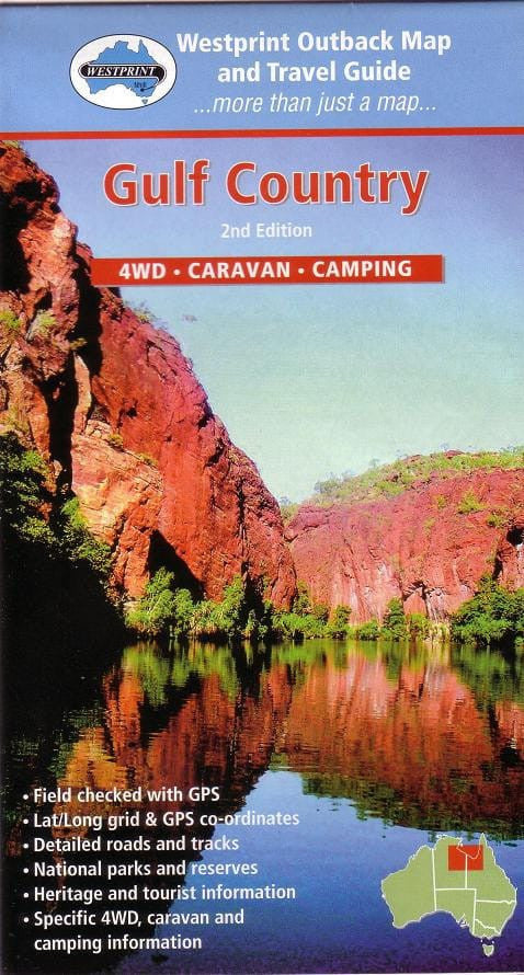
Gulf Country Map Westprint
Sold Out
Afterpay is only available for orders between $50.00 and $1000.00 More info
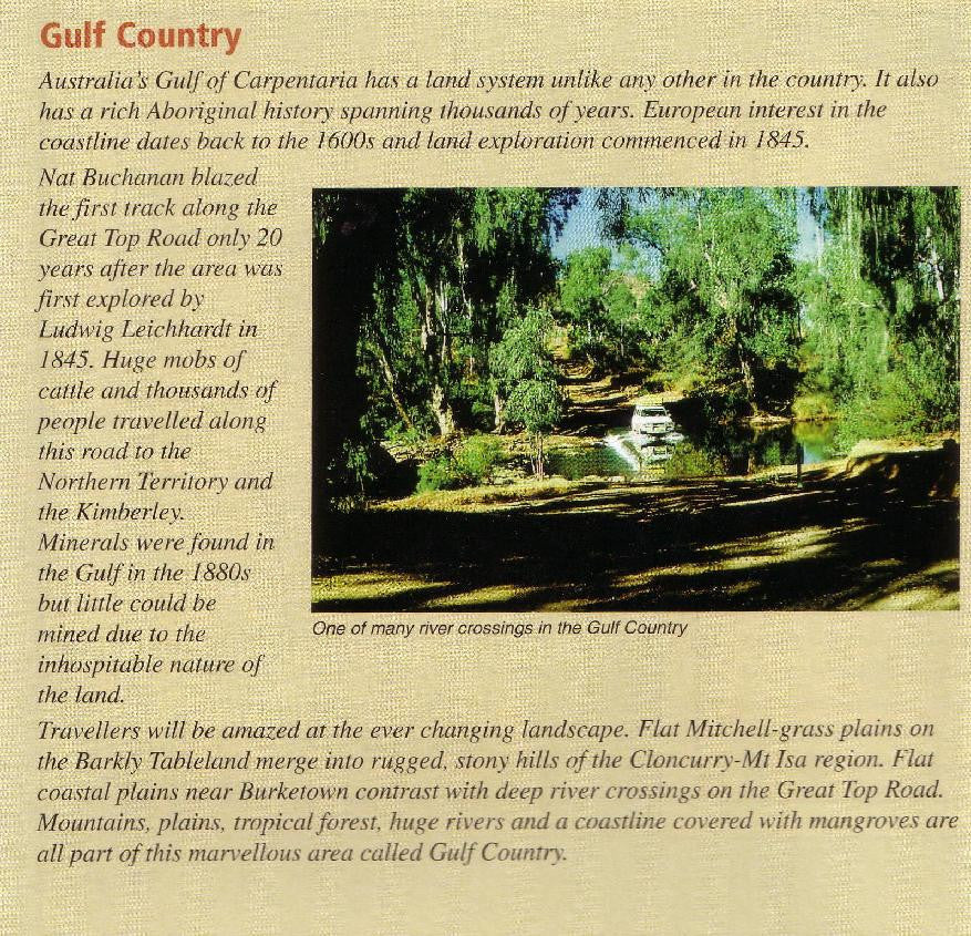
Your Essential Guide to Queensland’s Remote North-West
Specially designed for 4WD adventurers, caravanners, and campers, the Gulf Country Map by Westprint is a comprehensive and field-checked navigation tool for exploring one of Australia’s most remote and fascinating regions. From dusty outback highways to tropical wetlands and Indigenous cultural sites, this map puts clarity, accuracy, and essential travel information at your fingertips.
Whether you’re tackling rugged tracks, discovering historic towns, or seeking the serenity of isolated campsites, this map will support every leg of your journey through Queensland’s Gulf Savannah.
🧭 Key Features
✔️ Field Checked with GPS
All road and track data has been verified on the ground using GPS, ensuring real-world accuracy for your trip planning and navigation.
✔️ Latitude / Longitude Grid + GPS Coordinates
Makes it easy to sync your GPS or digital navigation device for precise tracking and off-grid route planning.
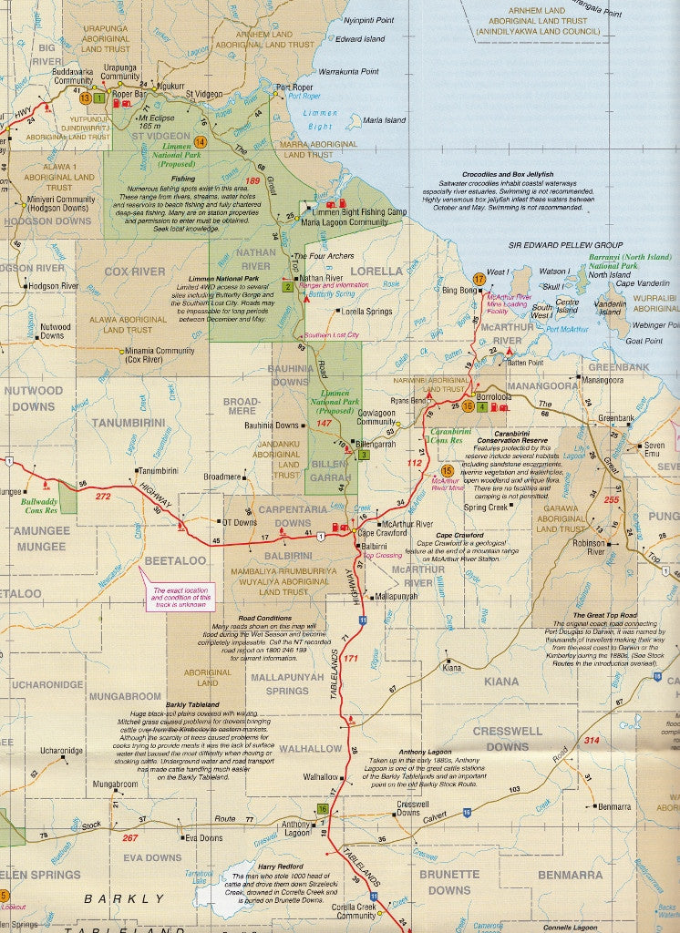
✔️ Detailed Roads and Tracks
Includes major highways, minor roads, 4WD tracks, station access roads, and unsealed routes—clearly marked for condition and suitability.
✔️ National Parks & Conservation Reserves
Boundaries and access to key parks such as Boodjamulla (Lawn Hill), Staaten River, and more.
✔️ Heritage & Tourist Information
Noteworthy landmarks, Aboriginal cultural sites, and historical points of interest are highlighted throughout.
✔️ 4WD, Caravan & Camping Facilities
Campsites, bush camps, rest areas, roadhouses, and fuel stops are marked to help you plan overnight stays and resupply points in this vast and often isolated region.
🗺️ Map Coverage
Covers the expansive Gulf Country region of north-western Queensland, including:
-
Normanton & Karumba
-
Burketown & Doomadgee
-
Boodjamulla (Lawn Hill) National Park
-
Gregory River Region
-
Mornington Island vicinity (inset)
-
The Savannah Way corridor (QLD section)
Perfect for those travelling between Mt Isa, Cloncurry, Normanton, Burketown, Lawn Hill, and the Queensland–NT border.
📏 Map Specifications
| Specification | Details |
|---|---|
| Scale | 1:1,500,000 |
| Map Dimensions | 700 mm (W) × 1000 mm (H) |
| Publisher | Westprint Heritage Maps |
| Map Format | Folded paper (lamination optional) |
| ISBN | [Available on request] |
🛠️ Optional Lamination Available
Upgrade your map with high-quality lamination to increase its durability and usability on the road:
-
✏️ Use with whiteboard markers for trip planning
-
💧 Water-resistant and tear-proof
-
📌 Ideal for use in caravans, campers, and 4WD setups
-
✅ Laminated using 80-micron gloss laminate (encapsulated front and back)
Note: Fold lines may be slightly visible beneath lamination.
🏕️ Perfect For:
-
🛻 4WD travellers exploring the Savannah Way
-
🚐 Caravanners and campers seeking remote Queensland adventures
-
🧭 Off-road navigators and overlanders heading into lesser-known regions
-
📚 A practical and educational resource for school or trip preparation
-
🐊 Wildlife watchers, outback historians, and cultural travellers
🏞️ Summary
The Gulf Country Map by Westprint is a rugged, reliable, and richly informative tool for those heading into one of Australia’s last great frontiers. Whether you’re crossing creeks in a 4WD, charting campsites under the stars, or following the ghost of explorers past, this map ensures you’re well prepared, well informed, and ready for anything.
📦 Order yours now—available in paper or laminated format—and start your Gulf Country journey with confidence.