- Australia ▾
- Topographic
▾
- Australia 50k Geoscience maps
- Australia 100k Geoscience maps
- Australia 250k Geoscience maps
- Australia 1.1m Geoscience maps
- New Zealand 50k maps
- New Zealand 250k maps
- New South Wales 25k maps
- New South Wales 50k maps
- New South Wales 100k maps
- Queensland 10k maps
- Queensland 25k maps
- Queensland 50k maps
- Queensland 100k maps
- Compasses
- Software
- GPS Systems
- Orienteering
- International ▾
- Wall Maps
▾
- World
- Australia & New Zealand
- Countries, Continents & Regions
- Historical
- Vintage National Geographic
- Australian Capital Territory
- New South Wales
- Northern Territory
- Queensland
- South Australia
- Tasmania
- Victoria
- Western Australia
- Celestial
- Children's
- Mining & Resources
- Wine Maps
- Healthcare
- Postcode Maps
- Electoral Maps
- Nautical ▾
- Flags
▾
- Australian Flag Sets & Banners
- Flag Bunting
- Handwavers
- Australian National Flags
- Aboriginal Flags
- Torres Strait Islander Flags
- International Flags
- Flagpoles & Accessories
- Australian Capital Territory Flags
- New South Wales Flags
- Northern Territory Flags
- Queensland Flags
- South Australia Flags
- Tasmania Flags
- Victoria Flags
- Western Australia Flags
- Gifts ▾
- Globes ▾
Dear valued customer. Please note that our checkout is not supported by old browsers. Please use a recent browser to access all checkout capabilities


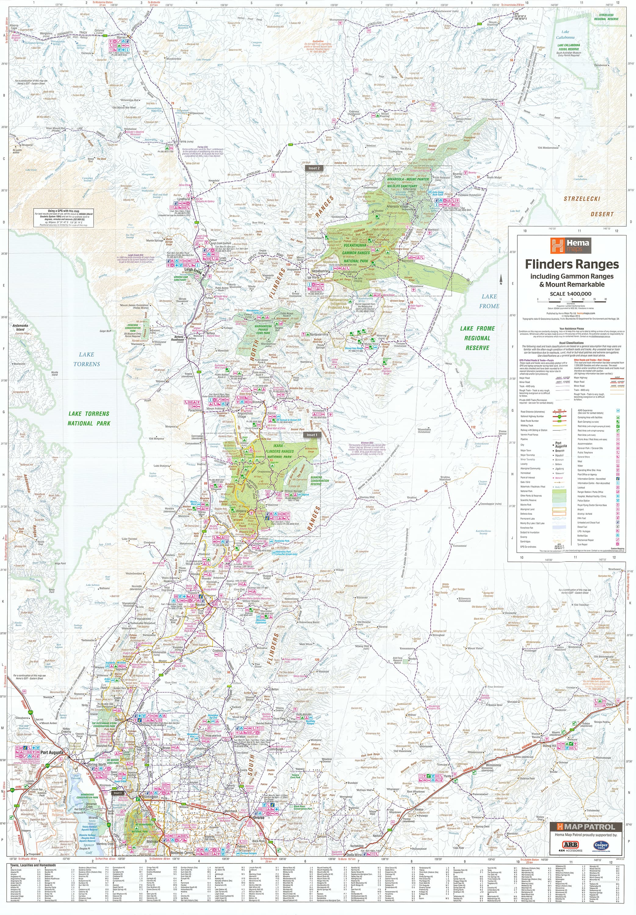
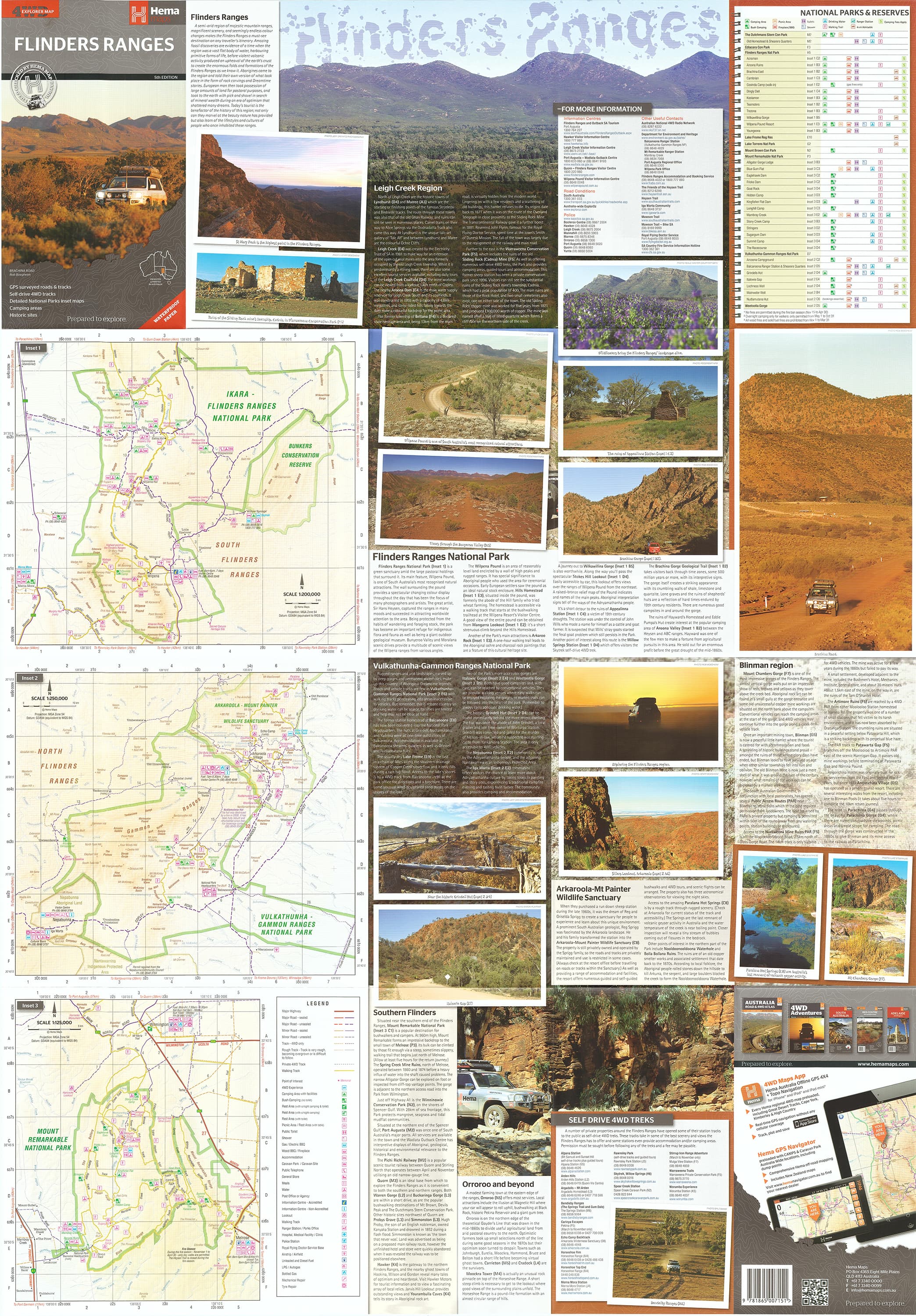

Flinders Ranges Hema Map 700 x 1000mm Laminated Wall Map
$45.00
Afterpay is only available for orders between $50.00 and $1000.00 More info
A waterproof map of the Flinders Ranges that is ideal for 4WD touring within the region. This great map has inset maps of the three major national parks in the area (Flinders NP, Gammon and Mount Remarkable NP) as well as a region map detailing all four-wheel drive tracks, walking trails, historic locations, waterholes and gorges. This map offers all the detail a traveller will need for a trip to the area.
This map features:
- GPS surveyed roads & tracks
- Self-drive 4WD tracks
- Detailed National Park inset maps
- Camping Areas
- Historic sites
This map comes laminated allowing you to draw on it in whiteboard marker or apply map dots to locations of interest without permanently marking the map. The lamination also makes the map very durable and protects against tears and stains.
To laminate this map we have taken the folded map and flattened it out before encapsulating it in high-quality 80-micron laminate, so please be aware that there will still be slight fold lines visible.
Scale: 1:400,000
Size: 700 mm (w) x 1000 mm (h)
Customer Reviews
Based on 12 reviews
Write a review
Related Items


© 2024 Mapworld. Website designed by Genie Media
X