- Australia ▾
- Topographic
▾
- Australia AUSTopo 250k (2025)
- Australia 50k Geoscience maps
- Australia 100k Geoscience maps
- Australia 250k Geoscience maps
- Australia 1:1m Geoscience maps
- New Zealand 50k maps
- New Zealand 250k maps
- New South Wales 25k maps
- New South Wales 50k maps
- New South Wales 100k maps
- Queensland 10k maps
- Queensland 25k maps
- Queensland 50k maps
- Queensland 100k maps
- Compasses
- Software
- GPS Systems
- Orienteering
- International ▾
- Wall Maps
▾
- World
- Australia & New Zealand
- Countries, Continents & Regions
- Historical
- Vintage National Geographic
- Australian Capital Territory
- New South Wales
- Northern Territory
- Queensland
- South Australia
- Tasmania
- Victoria
- Western Australia
- Celestial
- Children's
- Mining & Resources
- Wine Maps
- Healthcare
- Postcode Maps
- Electoral Maps
- Nautical ▾
- Flags
▾
- Australian Flag Sets & Banners
- Flag Bunting
- Handwavers
- Australian National Flags
- Aboriginal Flags
- Torres Strait Islander Flags
- International Flags
- Flagpoles & Accessories
- Australian Capital Territory Flags
- New South Wales Flags
- Northern Territory Flags
- Queensland Flags
- South Australia Flags
- Tasmania Flags
- Victoria Flags
- Western Australia Flags
- Gifts ▾
- Globes ▾
Dear valued customer. Please note that our checkout is not supported by old browsers. Please use a recent browser to access all checkout capabilities


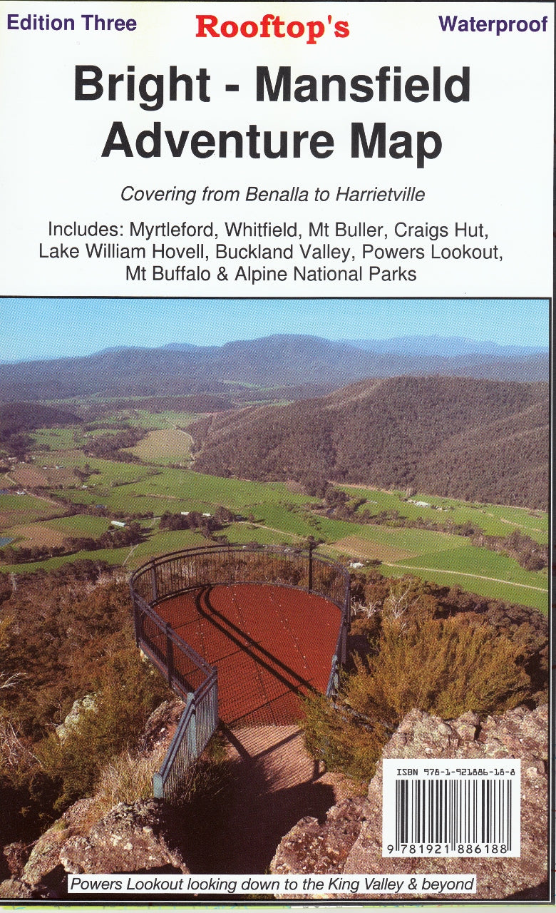
Bright-Mansfield Adventure Map Rooftop
$14.95 $15.95
Afterpay is only available for orders between $50.00 and $1000.00 More info
Includes Mount Buffalo, Wonnangatta & Alpine National Park
Optional Lamination | GPS-Mapped Tracks | Made in Australia 🇦🇺
The Ultimate Explorer’s Map for Victoria’s High Country
From alpine peaks to hidden valleys, the Bright–Mansfield Adventure Map by Rooftop Maps is your trusted companion for discovering one of Victoria’s most iconic wilderness regions. Covering a vast stretch of the High Country, this map is tailor-made for 4WD enthusiasts, hikers, campers, and outdoor adventurers seeking both the well-known highlights and the quiet corners off the beaten track.
Whether you're chasing snow at Mount Buller, seeking solitude near Lake Cobbler, or navigating to Wonnangatta Station through rugged terrain, this detailed topographic map is built to guide you every step (or tyre) of the way.
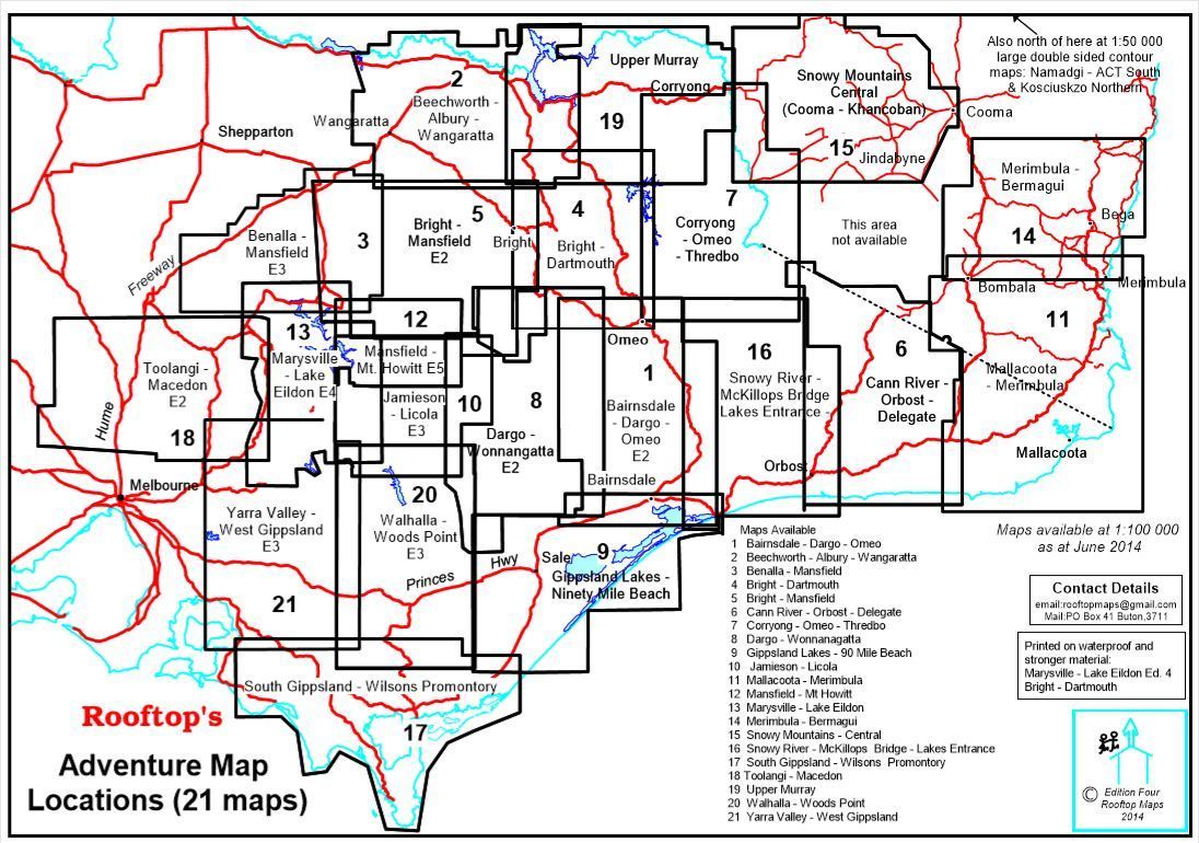
Comprehensive Coverage Area
This adventure map spans from Myrtleford, Bright, Moyhu, and Benalla in the north to Mansfield, Mount Buller, and Wonnangatta Station in the south. It includes:
-
Mount Buffalo National Park
-
Alpine National Park (northern section)
-
Harrietville, Buckland, Buffalo River, Whitfield, and Tolmie
-
Local landmarks such as Powers Lookout, Buckland Valley, and the King River region
This is rugged, remote, and rich country, beloved by photographers, trout fishers, and trail seekers alike — and it’s all covered in one fold-out, easy-to-read map.
Two Maps in One – Dual-Scale Detail
Front Map (Scale 1:100,000):
Gives a wide regional overview perfect for 4WD route planning, camping areas, forest navigation, and high-country touring.
Reverse Map (Scale 1:50,000):
Titled Bright–Whitfield Forest Activities Map, this detailed enlargement zeroes in on Mount Buffalo National Park and surrounding forest trails — ideal for bushwalking, trail running, mountain biking, and exploring smaller tracks.
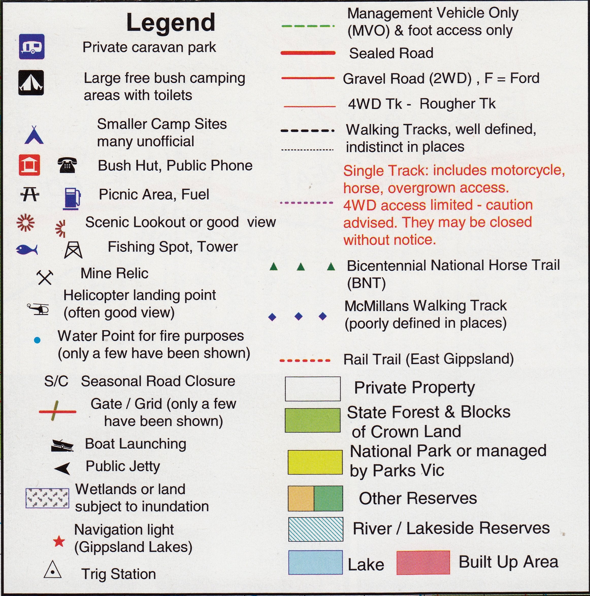
✅ Key Features
-
Accurate GPS-Mapped Roads & Tracks – Every track and road has been plotted using on-the-ground GPS fieldwork
-
All Parks, Reserves & State Forests – Fully outlined with clear access routes
-
Recommended 4WD Areas – Including Buffalo Valley, Toombullup, Cobbler Lake, Tolmie, King River, and more
-
Ideal for Bushwalking – In-depth trail coverage in Mount Buffalo & adjacent forest areas
-
Campsites, Lookouts, River Crossings, Waterholes – Clearly marked for ease of use
Optional Lamination – Built for Real-World Use
Upgrade your map with premium lamination, perfect for repeat use and rugged handling:
-
✅ Write-on/wipe-off surface – Use whiteboard markers to plan routes or mark campsites
-
✅ Compatible with our removable Map Dots – Great for tracking visited locations
-
✅ Tear-resistant & waterproof – Ideal for use in the car, at camp, or in the rain
-
✅ Long-lasting and protective – Prevents damage from folding, spills, and rough handling
🛠️ Note: Laminated maps are made from previously folded originals that have been flattened and sealed between two layers of 80-micron gloss laminate. Minor crease lines may remain visible but do not impact durability or function.
🏕️ Ideal For:
-
🚙 4WD Adventurers & Overlanders
-
🥾 Bushwalkers & Hikers
-
🏕️ Campers & Caravanners
-
🎣 Fly Fishers & River Explorers
-
🧭 Trail Runners, MTB Riders & Wildlife Spotters
-
📚 Backcountry Travel Planners & Map Collectors
📏 Product Details
| Feature | Specification |
|---|---|
| Title | Bright–Mansfield Adventure Map |
| Publisher | Rooftop Maps – Renowned for Victoria's High Country cartography |
| Primary Scale | 1:100,000 |
| Inset Map Scale | 1:50,000 (Bright–Whitfield Forest Activities Map) |
| Coverage Area | From Benalla & Moyhu to Mount Buller & Wonnangatta |
| Special Features | GPS-surveyed tracks, walking trails, 4WD routes, park boundaries |
| Format | Fold-out topographic map, optional lamination available |
| Printed In | Australia 🇦🇺 |
From alpine ridgelines to secret forest tracks, this is the most reliable way to explore Victoria’s High Country with confidence. Whether you’re navigating to Mount Buffalo for a summit walk or crawling your 4WD into the depths of Wonnangatta, this map keeps you on track and in the know.
Add this Rooftop Map to your kit today – and make sure you don’t miss a single lookout, river bend, or remote valley along the way.
Frequently Asked Questions
Where can I buy the Bright-Mansfield Adventure Map Rooftop?
The Bright-Mansfield Adventure Map Rooftop is available to buy online from Mapworld, Australia's largest map and geographic product retailer, with fast shipping Australia-wide.
Is the Bright-Mansfield Adventure Map Rooftop in stock at Mapworld?
Mapworld maintains extensive stock across its map range and aims for fast dispatch. Orders placed before 2pm AEST on business days are typically dispatched the same day, with standard and express Australia-wide delivery options available.
What is Mapworld's returns policy?
Mapworld accepts returns on undamaged items in original condition. Contact Mapworld within 90 days of purchase to arrange a return or exchange.
Does Mapworld ship the Bright-Mansfield Adventure Map Rooftop across Australia?
Yes, Mapworld ships Australia-wide. Standard shipping is a flat $7 rate, with free standard shipping on orders over $75. Express options are available at checkout. Most orders placed before 2pm AEST on weekdays are dispatched same day.
Related Items
© 2026 Mapworld. Website designed by Genie Media
X