- Australia ▾
- Topographic
▾
- Australia AUSTopo 250k (2025)
- Australia 50k Geoscience maps
- Australia 100k Geoscience maps
- Australia 250k Geoscience maps
- Australia 1:1m Geoscience maps
- New Zealand 50k maps
- New Zealand 250k maps
- New South Wales 25k maps
- New South Wales 50k maps
- New South Wales 100k maps
- Queensland 10k maps
- Queensland 25k maps
- Queensland 50k maps
- Queensland 100k maps
- Compasses
- Software
- GPS Systems
- Orienteering
- International ▾
- Wall Maps
▾
- World
- Australia & New Zealand
- Countries, Continents & Regions
- Historical
- Vintage National Geographic
- Australian Capital Territory
- New South Wales
- Northern Territory
- Queensland
- South Australia
- Tasmania
- Victoria
- Western Australia
- Celestial
- Children's
- Mining & Resources
- Wine Maps
- Healthcare
- Postcode Maps
- Electoral Maps
- Nautical ▾
- Flags
▾
- Australian Flag Sets & Banners
- Flag Bunting
- Handwavers
- Australian National Flags
- Aboriginal Flags
- Torres Strait Islander Flags
- International Flags
- Flagpoles & Accessories
- Australian Capital Territory Flags
- New South Wales Flags
- Northern Territory Flags
- Queensland Flags
- South Australia Flags
- Tasmania Flags
- Victoria Flags
- Western Australia Flags
- Gifts ▾
- Globes ▾
Dear valued customer. Please note that our checkout is not supported by old browsers. Please use a recent browser to access all checkout capabilities


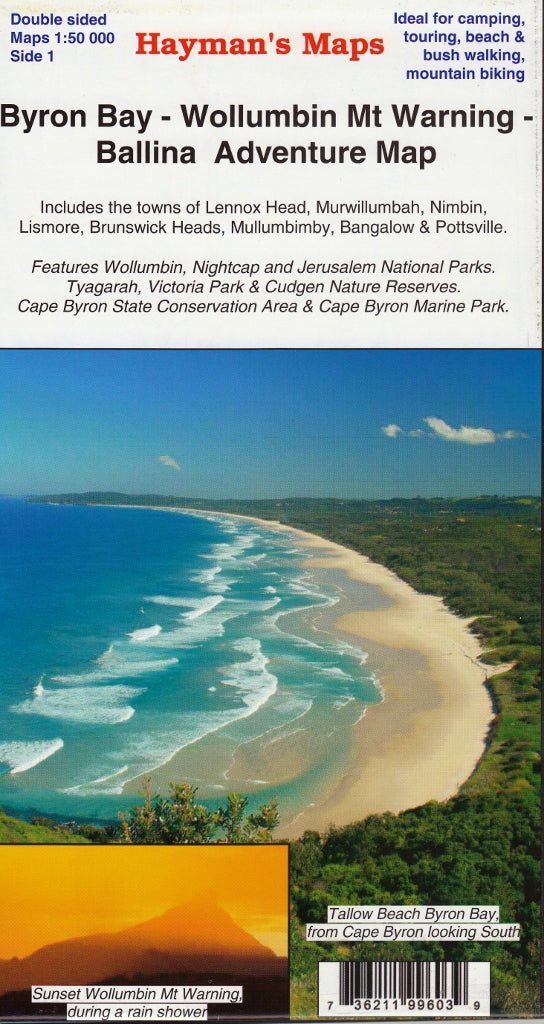
Byron Bay, Wollumbin Mt Warning, Ballina Adventure Map Rooftop
$12.95 $14.95
Afterpay is only available for orders between $50.00 and $1000.00 More info
Explore the Hinterland, Coastline & National Parks of Northern NSW
Scale: 1:50,000
Optional Lamination Available
Discover the rich natural beauty, cultural landmarks, and coastal charm of Northern New South Wales with the Byron Bay, Wollumbin & Ballina Adventure Map by Rooftop. Expertly designed for walkers, campers, nature lovers and day-trippers alike, this detailed 1:50,000 scale map covers a wide stretch of the NSW Northern Rivers region—from scenic beaches to ancient forests and iconic hinterland towns.
Map Coverage Includes:
-
Towns and Villages:
-
Byron Bay, Ballina, Lennox Head, Brunswick Heads
-
Mullumbimby, Bangalow, Murwillumbah, Nimbin, Pottsville, Lismore
-
-
National & Nature Parks:
-
Wollumbin (Mt Warning), Nightcap, and Jerusalem National Parks
-
Tyagarah, Victoria Park, and Cudgen Nature Reserves
-
Cape Byron State Conservation Area and Cape Byron Marine Park
-
This map showcases coastal access points, hinterland trails, nature reserves, rivers, and viewpoints, making it an essential planning tool for both locals and visitors.
Key Features:
-
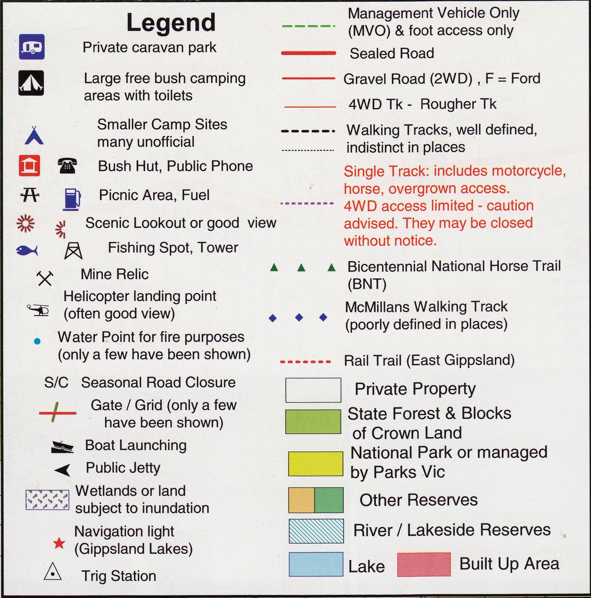
Clearly marked roads, unsealed tracks, walking trails, and forest drives
-
National parks and nature reserves outlined with full clarity
-
Rivers, ridgelines, topographic shading, and natural landmarks
-
Beach access, lookouts, and scenic drive routes
-
Perfect for campers, bushwalkers, cyclists, 4WD adventurers, and eco-tourists
Optional Laminated Edition
Upgrade to a laminated version for increased durability and functionality:
-
✅ Write on/wipe off surface—perfect for marking trails, campsites, or travel routes using whiteboard markers
-
✅ Compatible with map dots to mark key destinations
-
✅ Water-resistant and tear-proof, ideal for use in the field or on the road
Whether you're navigating rainforest trails or exploring the coast, the laminated option offers practical resilience for your adventures.
📐 Specifications
| Feature | Detail |
|---|---|
| Map Title | Byron Bay, Wollumbin & Ballina Adventure Map |
| Publisher | Rooftop Maps |
| Region Covered | Northern Rivers, NSW – Byron Hinterland & Coast |
| Towns Included | Byron Bay, Ballina, Murwillumbah, Nimbin, Mullumbimby, more |
| Parks Featured | Wollumbin, Nightcap, Jerusalem, Cape Byron Marine Park, others |
| Scale | 1:50,000 |
| Finish | Paper or optional laminated (80-micron gloss) |
| Format | Folded map (laminated version available flattened) |
| Use Case | Bushwalking, camping, touring, nature exploration |
Perfect For:
-
🌿 Nature lovers and bushwalkers seeking access to national parks and hidden trails
-
🚙 Self-drive travellers and campers exploring Northern NSW
-
🏄 Coastal adventurers and surfers navigating the beaches and conservation areas
-
🗺️ Travel planners and tour operators providing regional context
-
🎓 Educators and students studying Australian geography and ecology
From the rolling hinterland to the pristine coastline, the Byron Bay, Wollumbin & Ballina Adventure Map by Rooftop captures one of Australia’s most beloved regions in striking detail. Whether you're hiking through ancient rainforest or watching the sunrise from Cape Byron, this map is the perfect companion for discovering the heart of Northern New South Wales.
Plan it. Explore it. Mark your journey.
Frequently Asked Questions
Where can I buy the Byron Bay, Wollumbin Mt Warning, Ballina Adventure Map Rooftop?
The Byron Bay, Wollumbin Mt Warning, Ballina Adventure Map Rooftop is available to buy online from Mapworld, Australia's largest map and geographic product retailer, with fast shipping Australia-wide.
Is the Byron Bay, Wollumbin Mt Warning, Ballina Adventure Map Rooftop in stock at Mapworld?
Mapworld maintains extensive stock across its map range and aims for fast dispatch. Orders placed before 2pm AEST on business days are typically dispatched the same day, with standard and express Australia-wide delivery options available.
What is Mapworld's returns policy?
Mapworld accepts returns on undamaged items in original condition. Contact Mapworld within 90 days of purchase to arrange a return or exchange.
Does Mapworld ship the Byron Bay, Wollumbin Mt Warning, Ballina Adventure Map Rooftop across Australia?
Yes, Mapworld ships Australia-wide. Standard shipping is a flat $7 rate, with free standard shipping on orders over $75. Express options are available at checkout. Most orders placed before 2pm AEST on weekdays are dispatched same day.
Related Items
© 2026 Mapworld. Website designed by Genie Media
X