- Australia ▾
- Topographic
▾
- Australia AUSTopo 250k (2025)
- Australia 50k Geoscience maps
- Australia 100k Geoscience maps
- Australia 250k Geoscience maps
- Australia 1:1m Geoscience maps
- New Zealand 50k maps
- New Zealand 250k maps
- New South Wales 25k maps
- New South Wales 50k maps
- New South Wales 100k maps
- Queensland 10k maps
- Queensland 25k maps
- Queensland 50k maps
- Queensland 100k maps
- Compasses
- Software
- GPS Systems
- Orienteering
- International ▾
- Wall Maps
▾
- World
- Australia & New Zealand
- Countries, Continents & Regions
- Historical
- Vintage National Geographic
- Australian Capital Territory
- New South Wales
- Northern Territory
- Queensland
- South Australia
- Tasmania
- Victoria
- Western Australia
- Celestial
- Children's
- Mining & Resources
- Wine Maps
- Healthcare
- Postcode Maps
- Electoral Maps
- Nautical ▾
- Flags
▾
- Australian Flag Sets & Banners
- Flag Bunting
- Handwavers
- Australian National Flags
- Aboriginal Flags
- Torres Strait Islander Flags
- International Flags
- Flagpoles & Accessories
- Australian Capital Territory Flags
- New South Wales Flags
- Northern Territory Flags
- Queensland Flags
- South Australia Flags
- Tasmania Flags
- Victoria Flags
- Western Australia Flags
- Gifts ▾
- Globes ▾
Dear valued customer. Please note that our checkout is not supported by old browsers. Please use a recent browser to access all checkout capabilities


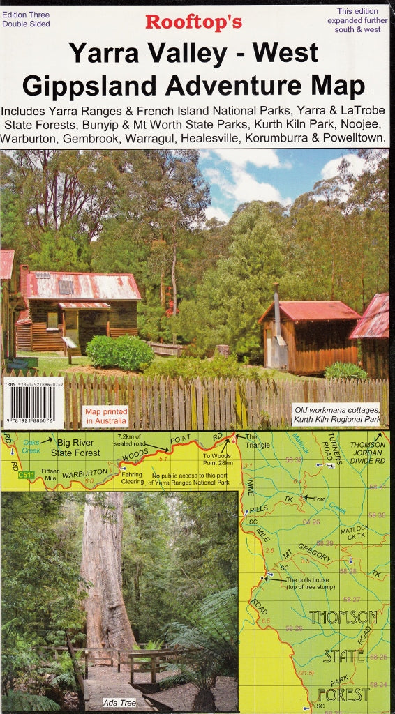
Yarra Valley - West Gippsland Adventure Map Rooftop
$13.95 $15.95
Afterpay is only available for orders between $50.00 and $1000.00 More info
Main Scale: 1:100,000 | Inset Scale: 1:50,000
Covers National Parks, Forest Tracks & Trails | GPS-Mapped | Optional Lamination
Made in Australia 🇦🇺
🏕️ Explore Victoria’s Lush Forests, Backroads & Hidden Trails
From the misty forests of Marysville to the rolling dairy lands of West Gippsland, the Yarra Valley – West Gippsland Adventure Map by Rooftop Maps offers a highly detailed and practical guide to one of Victoria’s most diverse and adventure-rich regions. Ideal for 4WD travellers, hikers, campers, and outdoor explorers, this map covers a broad area filled with state forests, mountain tracks, and national parks, all mapped with the precision Rooftop Maps is renowned for.
Whether you're chasing waterfalls near Warburton, navigating forest tracks through Bunyip, or heading out for a weekend in Noojee, this map will get you there — and back — with confidence.
🗺️ Coverage Area
This map covers a wide section of the Central Highlands to the foothills of West Gippsland, including:
-
🏞️ Yarra Ranges National Park
-
🌳 Bunyip State Park
-
🌲 Yarra State Forest & Mount Worth State Park
-
🧭 Towns and trail hubs like Marysville, Narbethong, Cumberland Junction, Noojee, Neerim South, Powelltown, Warragul, Trafalgar, Pakenham, Gembrook, and Kurth Kiln
Every track, backroad, trail, and forest route has been accurately mapped using GPS technology, giving you unmatched accuracy in the bush.
🔎 Two Maps in One – Front & Reverse
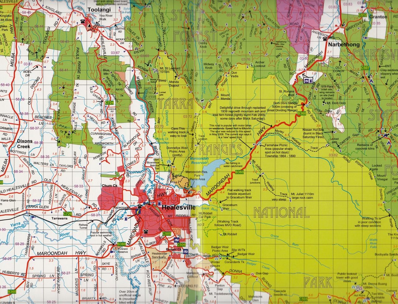
🗺️ Main Map – Scale 1:100,000
Covers the broader Yarra Valley–West Gippsland region with clear road classifications, walking tracks, campsites, lookouts, and terrain shading.
🧭 Reverse Side – Gembrook to Noojee Forest Activities Map (Scale 1:50,000)
This high-detail enlargement features contour lines, elevation shading, and fine-grain detail — perfect for bushwalkers, mountain bikers, and serious 4WDers.
✅ Features at a Glance
-
🧭 All roads and tracks GPS-surveyed – Ideal for off-road travel and real-world accuracy
-
🏕️ Campsites, picnic areas, river crossings, waterfalls & walking trails clearly marked
-
🌿 All parks, reserves & state forests clearly shaded and labelled
-
📍 Navigation-friendly layout with easy-to-read typography and intuitive design
-
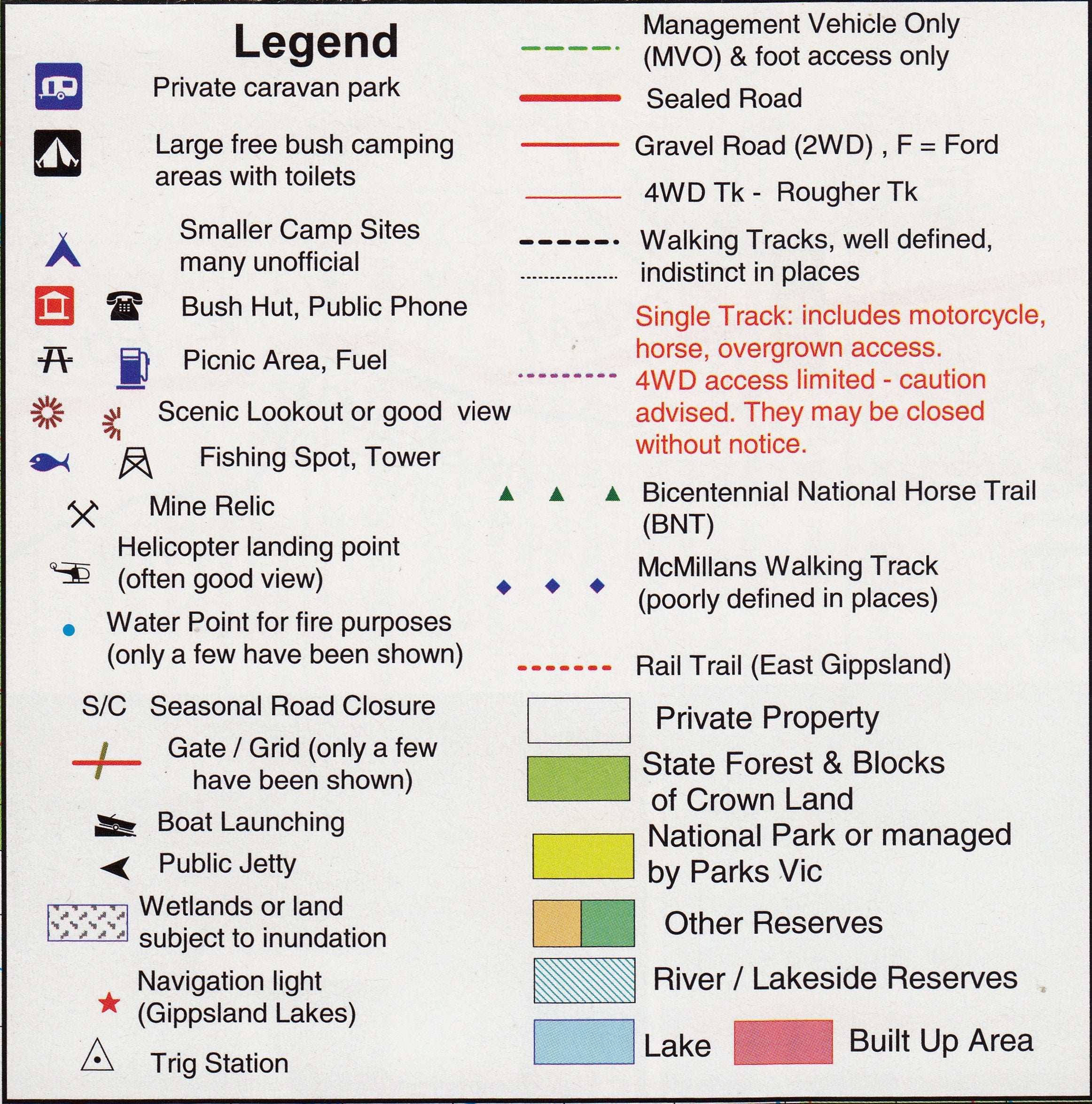
📜 Legend and mapping symbols are well organised for at-a-glance interpretation
✍️ Optional Lamination – Rugged & Reusable
Choose the laminated version for enhanced durability and flexibility:
-
✅ Write-on/wipe-off surface – Use whiteboard markers to plan routes or make trip notes
-
✅ Compatible with Map Dots – Mark favourite campsites or travel history without damage
-
✅ Tear-resistant, waterproof & stain-resistant – Perfect for wet, dusty or rugged field use
-
✅ Ideal for caravans, utes, or camp kitchens – Mount it or fold it as needed
🛠️ Note: Laminated versions are made by flattening and sealing previously folded maps between two sheets of 80-micron gloss laminate. Minor fold lines may still be visible but do not affect readability or performance.
🏕️ Perfect For:
-
🚙 4WD & Overland Adventurers
-
🥾 Hikers & Trail Walkers
-
🚵 Mountain Bikers
-
⛺ Campers & Caravaners
-
🎣 Fly Fishers & River Explorers
-
📚 Map Enthusiasts, Educators & Forest Rangers
📏 Product Specifications
| Feature | Description |
|---|---|
| Map Title | Yarra Valley – West Gippsland Adventure Map |
| Publisher | Rooftop Maps |
| Main Scale | 1:100,000 |
| Inset Map | Gembrook–Noojee Forest Activities Map (1:50,000 with contours) |
| Coverage Area | Marysville to Mount Worth; Yarra Valley to Gippsland |
| Map Type | Fold-out topographic adventure map |
| Lamination Option | Gloss laminated, write-on/wipe-off surface |
| Printed In | Australia 🇦🇺 |
🛒 Add to Cart Today
Ready to escape into Victoria’s green corridors and high-country backroads? The Yarra Valley – West Gippsland Adventure Map by Rooftop is your trusted guide to one of the most beautiful and rugged corners of the state — filled with waterfalls, fern gullies, and winding forest tracks.
Order now and take the guesswork out of your next off-grid adventure.
Frequently Asked Questions
Where can I buy the Yarra Valley - West Gippsland Adventure Map Rooftop?
The Yarra Valley - West Gippsland Adventure Map Rooftop is available to buy online from Mapworld, Australia's largest map and geographic product retailer, with fast shipping Australia-wide.
Is the Yarra Valley - West Gippsland Adventure Map Rooftop in stock at Mapworld?
Mapworld maintains extensive stock across its map range and aims for fast dispatch. Orders placed before 2pm AEST on business days are typically dispatched the same day, with standard and express Australia-wide delivery options available.
What is Mapworld's returns policy?
Mapworld accepts returns on undamaged items in original condition. Contact Mapworld within 90 days of purchase to arrange a return or exchange.
Does Mapworld ship the Yarra Valley - West Gippsland Adventure Map Rooftop across Australia?
Yes, Mapworld ships Australia-wide. Standard shipping is a flat $7 rate, with free standard shipping on orders over $75. Express options are available at checkout. Most orders placed before 2pm AEST on weekdays are dispatched same day.
Related Items


© 2026 Mapworld. Website designed by Genie Media
X