- Australia ▾
- Topographic
▾
- Australia AUSTopo 250k (2024)
- Australia 50k Geoscience maps
- Australia 100k Geoscience maps
- Australia 250k Geoscience maps
- Australia 1.1m Geoscience maps
- New Zealand 50k maps
- New Zealand 250k maps
- New South Wales 25k maps
- New South Wales 50k maps
- New South Wales 100k maps
- Queensland 10k maps
- Queensland 25k maps
- Queensland 50k maps
- Queensland 100k maps
- Compasses
- Software
- GPS Systems
- Orienteering
- International ▾
- Wall Maps
▾
- World
- Australia & New Zealand
- Countries, Continents & Regions
- Historical
- Vintage National Geographic
- Australian Capital Territory
- New South Wales
- Northern Territory
- Queensland
- South Australia
- Tasmania
- Victoria
- Western Australia
- Celestial
- Children's
- Mining & Resources
- Wine Maps
- Healthcare
- Postcode Maps
- Electoral Maps
- Nautical ▾
- Flags
▾
- Australian Flag Sets & Banners
- Flag Bunting
- Handwavers
- Australian National Flags
- Aboriginal Flags
- Torres Strait Islander Flags
- International Flags
- Flagpoles & Accessories
- Australian Capital Territory Flags
- New South Wales Flags
- Northern Territory Flags
- Queensland Flags
- South Australia Flags
- Tasmania Flags
- Victoria Flags
- Western Australia Flags
- Gifts ▾
- Globes ▾
Dear valued customer. Please note that our checkout is not supported by old browsers. Please use a recent browser to access all checkout capabilities


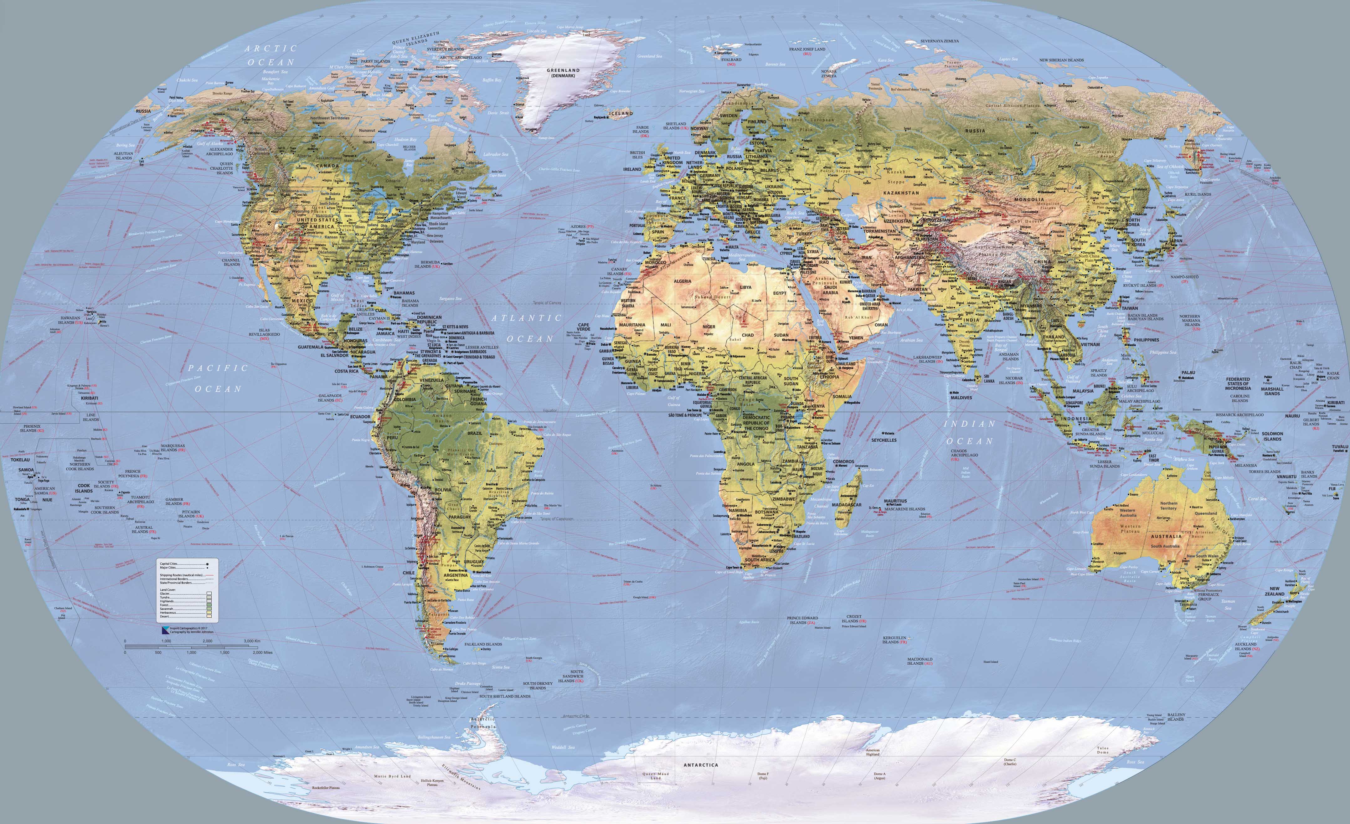
World Wall Map of Global Shipping Routes 1372 x 837mm
$79.95
or make 4 interest-free payments of
$19.99 AUD
fortnightly with
![]() More info
More info
A Striking Maritime Masterpiece for the Modern Age
Scale: 1:24,000,000
Size: 1372 mm (W) x 837 mm (H)
Proudly printed and finished in Australia
🌍 Overview
Where do the ships of the world go? This beautifully crafted World Wall Map of Global Shipping Routes answers that question at a glance, revealing the great circulatory system of global trade. With crisp, modern cartography overlaid with key oceanic shipping lanes, undersea features, and global geographic context, this map is as informative as it is decorative.
At a generous size of 1372 x 837 mm, the map is ideal for display in home offices, boardrooms, libraries, or anywhere you'd like to blend world-class cartography with visual impact. Whether you’re a logistics professional, geography educator, history buff, or ocean enthusiast, this is a map that invites closer inspection—and admiration.
🗺️ What This Map Shows
-
Major Global Shipping Routes – The most critical maritime pathways across the Atlantic, Pacific, and Indian Oceans, including strategic passages such as the Suez Canal, Panama Canal, and Straits of Gibraltar, Hormuz, and Malacca.
-
Submarine Topography – Oceanic ridges, trenches, basins, and seamounts bring the seafloor to life with subtle relief.
-
Mountain Peaks & Ranges – Includes major land-based geographic markers for global reference.
-
Political Borders & Major Cities – Country boundaries, capital cities, and important ports are marked for practical orientation.
-
Geographic Regions – Landmasses are labeled with clearly defined continents, countries, and regional groupings.
This is more than a wall map—it’s a visual atlas of global connectivity.
Available Formats
Choose from three premium finishes, tailored to your preferences and display needs:
🧾 Heavyweight Paper (160 gsm)
-
Smooth, matte paper stock
-
Ideal for professional framing under glass
-
Delivers crisp detail and soft surface tones
-
A lightweight and cost-effective display option
🛡️ Encapsulated Laminate
-
Fully encapsulated between two layers of 80-micron gloss laminate
-
Waterproof, tear-resistant, and wipe-clean
-
Exceptionally durable—ideal for classrooms, offices, or high-traffic areas
-
Maintains vibrant colours and resists creasing over time
🖼️ Canvas (395 gsm HP Professional Matte Canvas)
-
Printed using pigment-based archival inks for rich, fade-resistant colour
-
Luxurious, tactile texture—perfect for high-end interior settings
-
Long-lasting and museum-grade quality
-
Makes a bold and sophisticated statement in any room
Laminated & Canvas with Hanging Rails – Effortless Elegance
Looking for a ready-to-hang solution? Choose our canvas option with wooden hang rails for a timeless, minimalist finish.
-
Solid timber rollers attached top and bottom
-
Lacquered in a natural, warm wood tone
-
Discreet cord on the top rail for easy wall mounting—just one hook required
-
Professionally finished by our local framer for exceptional quality
-
Please allow 10 working days for preparation and assembly
This option offers a seamless blend of function and style—ideal for home offices, studies, or nautical-themed interiors.
✅ Features & Benefits
| Feature | Benefit |
|---|---|
| Global Shipping Lanes | Visualises the hidden network of global trade—great for maritime education or professional reference |
| Submarine Geography | Adds depth and context to the map—see the planet from both above and below sea level |
| Available in Three Finishes | Choose the style that suits your space: frameable paper, durable laminate, or premium canvas |
| Oversized Format (1372 x 837 mm) | Bold presence on any wall—large enough to study details, not so large as to overwhelm |
| Fade-Resistant Pigment Inks (Canvas) | Ensures your map remains vibrant for years—ideal for long-term display |
| Made in Australia | Locally printed and finished with expert craftsmanship and quality control |
| Optional Hanging Rails (Canvas) | Elegant, practical, and ready to install—no framing or glass required |
Perfect For
-
Maritime professionals & global logistics teams – An indispensable reference tool
-
Geography teachers & students – Ideal for classrooms and interactive learning
-
Home office décor – Adds visual interest and intellectual appeal
-
Libraries, shipping companies, and naval academies – Informative, professional, and polished
-
Travel enthusiasts and map collectors – A unique piece with both aesthetic and educational value
-
Gift buyers – For captains, seafarers, historians, or anyone fascinated by how the world moves
📦 Product Specifications
-
Scale: 1:24,000,000
-
Size: 1372 mm wide x 837 mm high
-
Finish Options:
-
Matte paper (160 gsm)
-
Encapsulated gloss laminate (80-micron both sides)
-
HP Professional Matte Canvas (395 gsm)
-
-
Optional Canvas Hanging Rails: Natural lacquered timber with top cord
-
Production Time for Hang-Railed Canvas: Please allow 10 business days
-
Made in: Australia
A Map That Connects Continents—and Captivates the Eye
This World Wall Map of Global Shipping Routes is more than decoration. It’s an insight into how the world works—how goods move, how nations link, and how the oceans serve as the global marketplace. Whether you’re planning logistics, teaching global trade, or simply admiring the complexity of our planet, this map makes a powerful and lasting impression.
🛒 Add to your cart today and enjoy a timeless map that’s both educational and elegant.


