


See the world through the lens of people, not borders
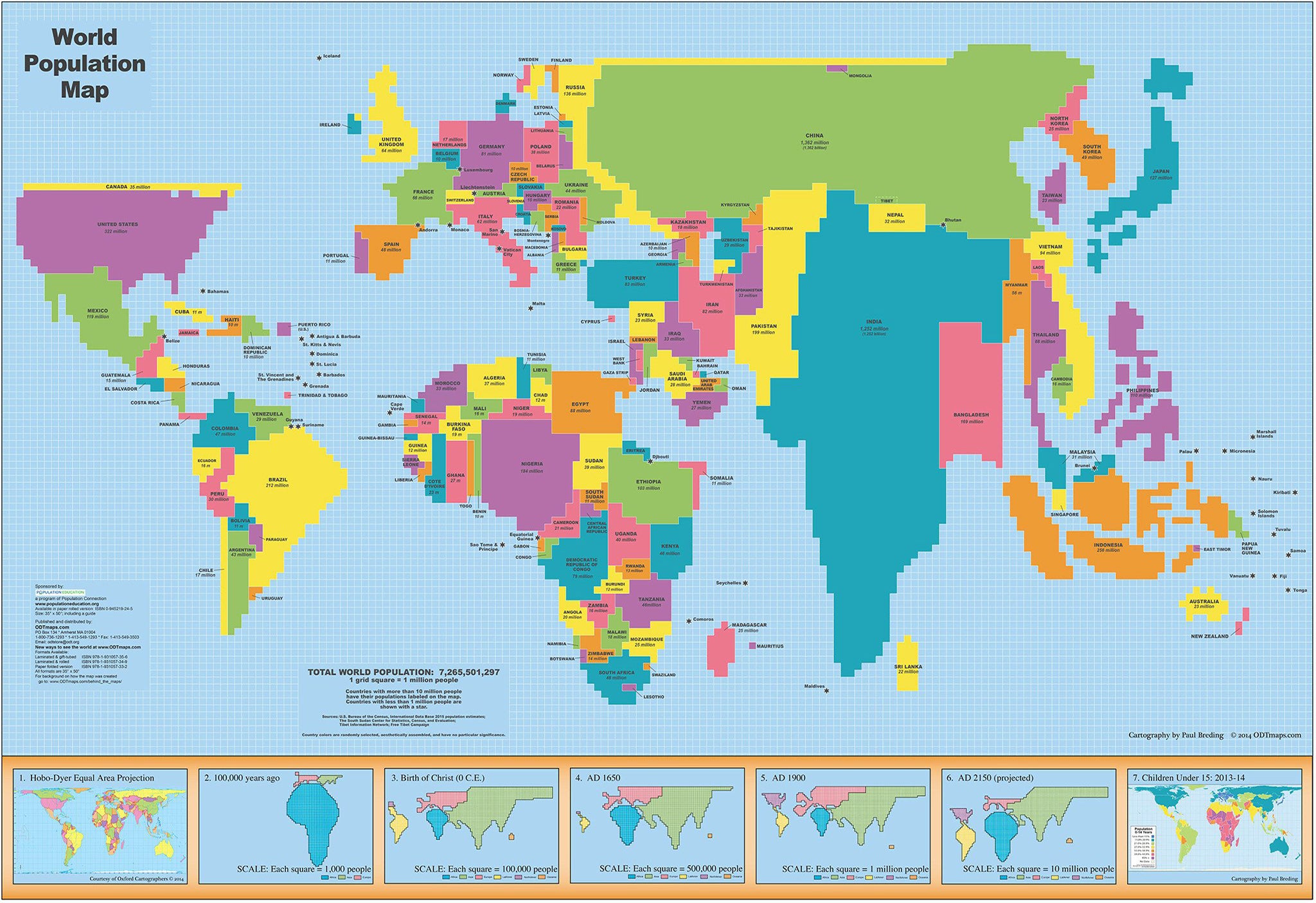
This striking World Population Map transforms global geography into a powerful and enlightening visual experience. Based on 2015 data from the U.S. State Department, this map doesn’t show the world by landmass or politics—it shows it by population.
Each grid square represents 1 million people, giving you a dramatic sense of human distribution across the globe. Countries swell or shrink relative to their populations, making this map a brilliant educational tool and conversation starter for homes, offices, classrooms, and think tanks alike.
A Map That Tells the Human Story
-
China dominates the landscape as the most populous country in the world.
-
India, a close second, expands nearly as wide.
-
Indonesia, Pakistan, and Nigeria loom much larger than they do on traditional maps.
-
The United States, long viewed as a global powerhouse, accounts for just under 4.5% of the world’s population—a striking visual comparison that reshapes how we see global influence.
This map challenges conventional worldviews and makes abstract population statistics tangible and intuitive.
📊 Historical & Predictive Insights
A timeline of human population through the ages is displayed along the bottom panel. These visual snapshots offer a compelling journey through population history:
-
100,000 years ago – Humanity’s origins and early migration
-
At the time of Christ – Approx. 300 million people on Earth
-
1650 AD – The world begins to fill out
-
1900 AD – Population booms with industrialisation
-
2150 AD (projected) – What’s ahead if current trends continue
Also included:
📌 A special panel showing the percentage of children under 15 by country—a key demographic indicator of future population growth and development pressures.
Durable & Interactive Laminated Finish
Printed on high-quality paper and laminated with 80-micron gloss, this map is designed to be:
-
Wipe-clean – Use whiteboard markers for planning or study
-
Map-dot friendly – Mark places of interest without leaving a trace
-
Tear-resistant & spill-proof – Ideal for busy environments or classrooms
Whether you’re educating, presenting, or just curious, this map invites interaction and exploration.
📐 Specifications
| Attribute | Detail |
|---|---|
| Title | World Population Map (2015 Edition) |
| Theme | Human Population (not landmass) |
| Publisher | [Publisher Name, if known] |
| Format | Flat, Laminated Wall Map |
| Size | 1270 mm (W) × 890 mm (H) |
| Finish | Gloss Lamination |
| Projection | Population Grid |
| Extras | Population Timeline & Youth Percentage Panel |
🏠 Perfect For:
-
Geography and demography classrooms
-
Policy and planning departments
-
Libraries and university common areas
-
Home offices or global business teams
-
Anyone passionate about understanding humanity’s footprint
The World Population Map is more than geography—it's a mirror held up to humanity. Gain a deeper understanding of where we live, how we’ve grown, and where we might be heading next.


