- Australia ▾
- Topographic
▾
- Australia AUSTopo 250k (2025)
- Australia 50k Geoscience maps
- Australia 100k Geoscience maps
- Australia 250k Geoscience maps
- Australia 1:1m Geoscience maps
- New Zealand 50k maps
- New Zealand 250k maps
- New South Wales 25k maps
- New South Wales 50k maps
- New South Wales 100k maps
- Queensland 10k maps
- Queensland 25k maps
- Queensland 50k maps
- Queensland 100k maps
- Compasses
- Software
- GPS Systems
- Orienteering
- International ▾
- Wall Maps
▾
- World
- Australia & New Zealand
- Countries, Continents & Regions
- Historical
- Vintage National Geographic
- Australian Capital Territory
- New South Wales
- Northern Territory
- Queensland
- South Australia
- Tasmania
- Victoria
- Western Australia
- Celestial
- Children's
- Mining & Resources
- Wine Maps
- Healthcare
- Postcode Maps
- Electoral Maps
- Nautical ▾
- Flags
▾
- Australian Flag Sets & Banners
- Flag Bunting
- Handwavers
- Australian National Flags
- Aboriginal Flags
- Torres Strait Islander Flags
- International Flags
- Flagpoles & Accessories
- Australian Capital Territory Flags
- New South Wales Flags
- Northern Territory Flags
- Queensland Flags
- South Australia Flags
- Tasmania Flags
- Victoria Flags
- Western Australia Flags
- Gifts ▾
- Globes ▾
Dear valued customer. Please note that our checkout is not supported by old browsers. Please use a recent browser to access all checkout capabilities
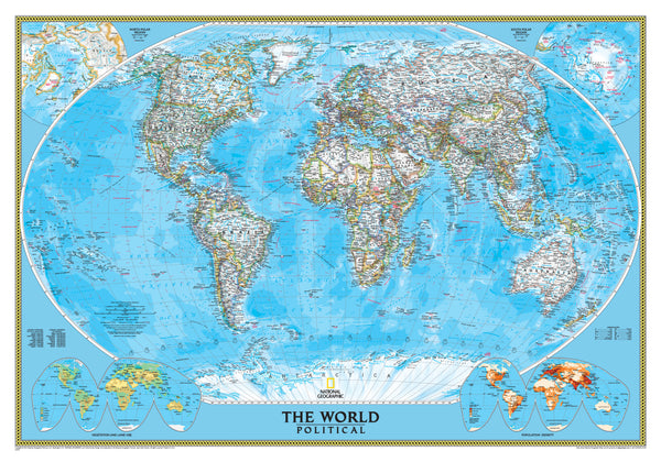
World Political National Geographic 2794 x 1930mm Mural 3 Sheet Wallpaper Map
$299.95
or make 4 interest-free payments of
$74.99 AUD
fortnightly with
![]() More info
More info
Size: 2794 mm (W) × 1930 mm (H)
Printed in 3 Panels | Laminated or Paper Options Available
A Monumental Map. A Masterpiece of Geography.
Make a bold statement with this stunning World Political Mural Map by National Geographic—a cartographic tour de force that transforms walls into windows on the world. Spanning nearly three metres wide and two metres high, this mural commands attention in any space: from the executive boardroom and university library to the home study or classroom.
🌍 A World View with Depth and Clarity
This is no ordinary map. Rendered in National Geographic’s signature political style, this mural features:
-
Winkel Tripel projection for minimal distortion and balanced global perspective
-
Shaded relief showcasing Earth's dramatic mountain ranges
-
Bathymetry and ocean currents, revealing the dynamic nature of the seas
-
Inset maps of global vegetation, land use, and population density
-
High-contrast borders with country interiors in soft white for easy reading
-
Thousands of place names, capital cities, rivers, lakes, and mountain ranges
Whether you're planning your next journey, studying global systems, or simply admiring Earth's grandeur—this mural brings the world into focus like few others can.
📐 Product Specifications
| Feature | Details |
|---|---|
| Map Style | Political with terrain, oceans & global thematic insets |
| Projection | Winkel Tripel (minimises distortion) |
| Size | 2794 mm (W) × 1930 mm (H) |
| Format | Supplied in 3 rolled panels for easy installation |
| Information | Country borders, capitals, rivers, oceans, bathymetry, land use & population |
🖼️ Finish Options
| Format | Description |
|---|---|
| Paper | Printed on heavyweight 160gsm matte paper. Ideal for custom framing or adhesive wall mounting. |
| Laminated | Encapsulated in premium 80-micron gloss laminate (front & back) for a smooth, durable, waterproof finish. ➕ Made to order: please allow 14–30 days for delivery. |
All versions are supplied rolled in 3 panels and professionally packaged to prevent damage in transit.
✨ Why You’ll Love This Mural
-
🧭 Educational & Informative – Packed with up-to-date data and beautifully legible.
-
🖼️ Decorative & Inspiring – A bold, elegant centrepiece for office, school, or home.
-
🌏 Functional & Accurate – Designed by one of the world’s most trusted cartographic institutions.
-
🧱 Flexible Installation – Hang as is, mount on backing boards, or frame in panels—your wall, your way.
🚚 Delivery Information
-
Paper Format: Ships in approx. 14–30 business days
-
Laminated Format: Made to order – allow 14–30 days for production and delivery
-
Packaging: Rolled in secure protective tubing
-
Panels: Delivered in 3 separate sheets for easy hanging
Whether you're charting the course of history, exploring modern geopolitics, or simply adorning your walls with a piece of global artistry, the National Geographic World Political Mural Map offers an unrivalled combination of beauty, information, and scale.


