- Australia ▾
- Topographic
▾
- Australia AUSTopo 250k (2024)
- Australia 50k Geoscience maps
- Australia 100k Geoscience maps
- Australia 250k Geoscience maps
- Australia 1.1m Geoscience maps
- New Zealand 50k maps
- New Zealand 250k maps
- New South Wales 25k maps
- New South Wales 50k maps
- New South Wales 100k maps
- Queensland 10k maps
- Queensland 25k maps
- Queensland 50k maps
- Queensland 100k maps
- Compasses
- Software
- GPS Systems
- Orienteering
- International ▾
- Wall Maps
▾
- World
- Australia & New Zealand
- Countries, Continents & Regions
- Historical
- Vintage National Geographic
- Australian Capital Territory
- New South Wales
- Northern Territory
- Queensland
- South Australia
- Tasmania
- Victoria
- Western Australia
- Celestial
- Children's
- Mining & Resources
- Wine Maps
- Healthcare
- Postcode Maps
- Electoral Maps
- Nautical ▾
- Flags
▾
- Australian Flag Sets & Banners
- Flag Bunting
- Handwavers
- Australian National Flags
- Aboriginal Flags
- Torres Strait Islander Flags
- International Flags
- Flagpoles & Accessories
- Australian Capital Territory Flags
- New South Wales Flags
- Northern Territory Flags
- Queensland Flags
- South Australia Flags
- Tasmania Flags
- Victoria Flags
- Western Australia Flags
- Gifts ▾
- Globes ▾
Dear valued customer. Please note that our checkout is not supported by old browsers. Please use a recent browser to access all checkout capabilities
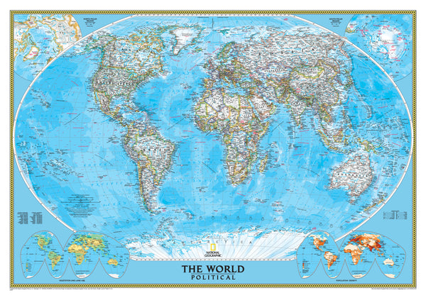
World Political National Geographic 1100 x 780mm (Africa Centred) Wall Map
$89.95
or make 4 interest-free payments of
$22.49 AUD
fortnightly with
![]() More info
More info
🌍 World Political Wall Map – Africa-Centred
By National Geographic
Size: 1100 mm (W) × 780 mm (H) | Projection: Winkel Tripel | Scale: 1:36,384,000
Available Finishes: Paper • Laminated • Canvas • Optional Timber Hang Rails
Made in Australia
🗺 Rethink Your World Perspective
Place Africa at the very heart of your worldview with this Africa-Centred Political World Map from the renowned National Geographic Society. By repositioning the world’s continents, this map offers a fresh, inclusive perspective that challenges the traditional Europe-centred view.
Whether for classroom teaching, international business, or home décor, this map delivers outstanding cartographic accuracy, rich geographic detail, and timeless design—making it a stunning and practical addition to any wall.
📌 Key Cartographic Features
Africa-Centred Projection
-
Balanced perspective that highlights Africa’s geographic centrality.
-
Refreshing alternative to traditional layouts, ideal for educational discussions.
Winkel Tripel Projection
-
Minimises distortion for accurate and elegant presentation.
-
Preferred by cartographers for balance between area, shape, and distance accuracy.
Political & Physical Detail
-
Clear country borders with bold die lines.
-
White interiors for high-contrast readability.
-
Shaded relief showing mountains and elevated terrain.
-
Ocean depths and currents for a scientific dimension.
Inset Maps & Reference Layers
-
Population density.
-
Vegetation zones.
-
Global land use patterns.
🎨 Premium Printing Options
Heavyweight Archival Paper (160 gsm)
-
Crisp, matte finish for exceptional clarity.
-
Perfect for framing under glass in homes, offices, or libraries.
Encapsulated Gloss Laminate
-
Fully sealed with two layers of 80-micron gloss laminate.
-
Wipe clean, reusable, and UV-protected.
-
Suitable for classrooms and high-traffic spaces.
HP Professional Matte Canvas (395 gsm)
-
Printed with archival pigment-based inks.
-
Fade-resistant and waterproof for longevity.
-
Tactile, gallery-grade finish for an artistic display.
🪵 Optional Wooden Hang Rails
-
Lacquered natural timber finish for a refined look.
-
Pre-fitted top and bottom rails keep your map flat.
-
Ready-to-hang cord for quick, frame-free mounting.
Note: Please allow up to 10 working days for delivery of hang-railed maps as each is custom-mounted by our framer.
📏 Specifications
| Feature | Details |
|---|---|
| Publisher | National Geographic Society |
| Projection | Winkel Tripel |
| Map Style | Political (Africa-Centred) |
| Inset Maps | Population, Vegetation, Land Use |
| Finishes | Paper (160 gsm), Laminated (80-micron gloss), Canvas (395 gsm) |
| Optional | Timber hang rails (natural finish) |
| Scale | 1:36,384,000 |
| Dimensions | 1100 mm (W) × 780 mm (H) |
| Made In | Australia |
🌟 Why This Map Stands Out
-
A new perspective that places Africa at the centre.
-
Backed by National Geographic’s 135+ years of cartographic excellence.
-
Equally suitable as an educational tool or as wall art.
-
Multiple finish options to suit every setting.
-
Optional hang rails for professional, ready-to-hang presentation.
See the world differently—place Africa at its heart
This Africa-Centred Political World Map offers beauty, accuracy, and inspiration in one piece. Whether in archival paper, durable laminate, or luxurious canvas, it’s a world map that truly makes a statement.
Order today and bring a balanced, globally inclusive view into your space.


