- Australia ▾
- Topographic
▾
- Australia AUSTopo 250k (2025)
- Australia 50k Geoscience maps
- Australia 100k Geoscience maps
- Australia 250k Geoscience maps
- Australia 1:1m Geoscience maps
- New Zealand 50k maps
- New Zealand 250k maps
- New South Wales 25k maps
- New South Wales 50k maps
- New South Wales 100k maps
- Queensland 10k maps
- Queensland 25k maps
- Queensland 50k maps
- Queensland 100k maps
- Western Australia 25k maps
- Western Australia 50k maps
- Western Australia 100k maps
- Compasses
- Software
- GPS Systems
- International ▾
- Wall Maps
▾
- World
- Australia & New Zealand
- Countries, Continents & Regions
- Historical
- Vintage National Geographic
- Australian Capital Territory
- New South Wales
- Northern Territory
- Queensland
- South Australia
- Tasmania
- Victoria
- Western Australia
- Celestial
- Children's
- Mining & Resources
- Wine Maps
- Healthcare
- Postcode Maps
- Electoral Maps
- Nautical ▾
- Flags
▾
- Australian Flag Sets & Banners
- Flag Bunting
- Handwavers
- Australian National Flags
- Aboriginal Flags
- Torres Strait Islander Flags
- International Flags
- Flagpoles & Accessories
- Australian Capital Territory Flags
- New South Wales Flags
- Northern Territory Flags
- Queensland Flags
- South Australia Flags
- Tasmania Flags
- Victoria Flags
- Western Australia Flags
- Gifts ▾
- Globes ▾
Dear valued customer. Please note that our checkout is not supported by old browsers. Please use a recent browser to access all checkout capabilities


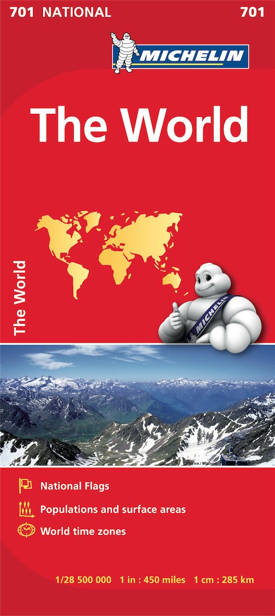
World Michelin Europe Centred Folded Map 701
$21.95
Afterpay is only available for orders between $50.00 and $1000.00 More info
A Bold, Colourful View of Our World – With Every Flag Flying Proud
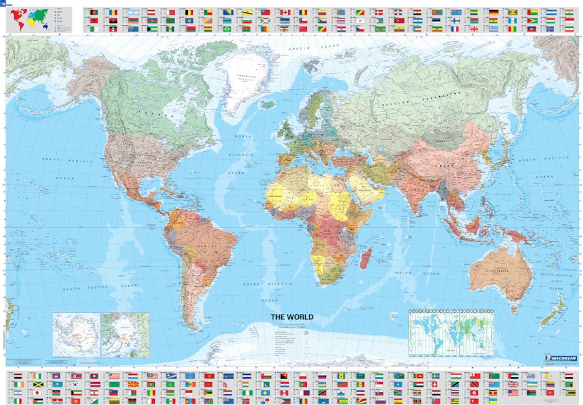
This beautifully designed World Political Map by Michelin is more than a reference tool—it’s a striking centrepiece for the home, office, library, or classroom. Centred on Europe and rendered in vibrant political colours, the map provides a detailed overview of the globe as only Michelin can deliver—clear, authoritative, and visually engaging.
Renowned for its cartographic precision, Michelin has enriched this map with a full set of national flags, offering an eye-catching international element that both educates and inspires. It also features time zone information, making it a practical tool for travellers, businesses, and global citizens alike.
🧭 Key Features
| 🌐 Feature | ✅ Details |
|---|---|
| Projection | Europe-centred world map |
| Content | Political boundaries, capital cities, major cities, oceans, and seas |
| Extras | All national flags included along the bottom of the map |
| Time Zones | Global time zones clearly marked for reference |
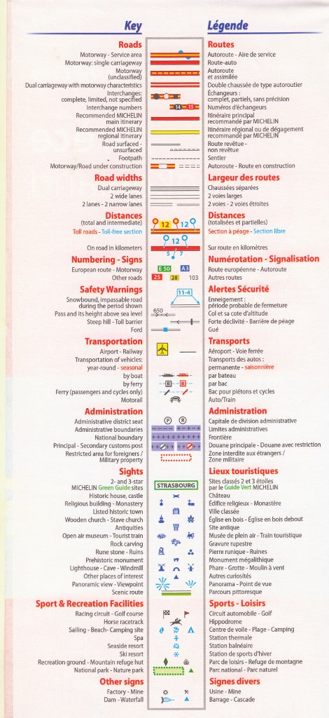
| Printing | High-resolution colour printing on durable map stock |
| Folding Style | Folded for easy storage or travel use |
| Cartography by | Michelin – globally trusted mapmakers for over a century |
📏 Specifications
-
Scale: 1:28,500,000
-
Unfolded Size: 1400 mm (W) × 1010 mm (H)
-
Format: Folded paper map
-
Language: Multilingual key (includes English)
🎓 Ideal For
-
Classrooms and geography studies
-
Offices and boardrooms with international connections
-
Travel enthusiasts and armchair explorers
-
Educational gifts for students or teachers
-
Wall displays (can be laminated or framed if desired)
Whether you’re planning your next international adventure, teaching global geography, or simply admiring the vast spread of our planet, the Michelin Europe-Centred World Map brings clarity, colour, and curiosity to any wall it graces.
A timeless reference. A global perspective. A world at your fingertips.
Frequently Asked Questions
What area does the World Michelin Europe Centred Folded Map 701 cover?
The World Michelin Europe Centred Folded Map 701 provides road coverage of the region named in the product title. The map covers major cities, highways, towns, and regional roads, with inset city maps for key urban centres where applicable.
Is the World Michelin Europe Centred Folded Map 701 up to date?
Yes, this is the current edition. Mapworld stocks the most current editions from all major publishers, updated to reflect new roads and infrastructure.
What size is this map when unfolded?
Folded maps from Mapworld's range are compact and portable. Most standard folded road or travel maps open to between A1 (594 × 841mm) and A0 (841 × 1189mm) when fully unfolded, and fold down to approximately A4 or smaller for easy storage in a glove box, bag, or backpack.
Is the World Michelin Europe Centred Folded Map 701 in stock at Mapworld?
Mapworld maintains extensive stock across its map range and aims for fast dispatch. Orders placed before 2pm AEST on business days are typically dispatched the same day, with standard and express Australia-wide delivery options available.
Does Mapworld ship the World Michelin Europe Centred Folded Map 701 across Australia?
Yes, Mapworld ships Australia-wide. Standard shipping is a flat $7 rate, with free standard shipping on orders over $75. Express options are available at checkout. Most orders placed before 2pm AEST on weekdays are dispatched same day.
Related Items


© 2026 Mapworld. Website designed by Genie Media
X