- Australia ▾
- Topographic
▾
- Australia AUSTopo 250k (2024)
- Australia 50k Geoscience maps
- Australia 100k Geoscience maps
- Australia 250k Geoscience maps
- Australia 1.1m Geoscience maps
- New Zealand 50k maps
- New Zealand 250k maps
- New South Wales 25k maps
- New South Wales 50k maps
- New South Wales 100k maps
- Queensland 10k maps
- Queensland 25k maps
- Queensland 50k maps
- Queensland 100k maps
- Compasses
- Software
- GPS Systems
- Orienteering
- International ▾
- Wall Maps
▾
- World
- Australia & New Zealand
- Countries, Continents & Regions
- Historical
- Vintage National Geographic
- Australian Capital Territory
- New South Wales
- Northern Territory
- Queensland
- South Australia
- Tasmania
- Victoria
- Western Australia
- Celestial
- Children's
- Mining & Resources
- Wine Maps
- Healthcare
- Postcode Maps
- Electoral Maps
- Nautical ▾
- Flags
▾
- Australian Flag Sets & Banners
- Flag Bunting
- Handwavers
- Australian National Flags
- Aboriginal Flags
- Torres Strait Islander Flags
- International Flags
- Flagpoles & Accessories
- Australian Capital Territory Flags
- New South Wales Flags
- Northern Territory Flags
- Queensland Flags
- South Australia Flags
- Tasmania Flags
- Victoria Flags
- Western Australia Flags
- Gifts ▾
- Globes ▾
Dear valued customer. Please note that our checkout is not supported by old browsers. Please use a recent browser to access all checkout capabilities
World 1:20 million 2000 x 1200mm Wall Map with FREE Map Dots 2024
$179.95
or make 4 interest-free payments of
$44.99 AUD
fortnightly with
![]() More info
More info
A spectacular centrepiece for any space — blending clarity, scale, and colour into one of the most striking single-sheet world maps available today
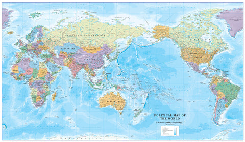
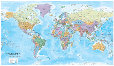
Step into a world of scale and detail with the World Maps International Political World Map, measuring an impressive 2 metres wide by 1.2 metres high. Printed at a 1:20 million scale, this expansive single-sheet map is designed to be both visually engaging and highly informative, offering an unparalleled view of the globe’s nations, capitals, landforms, and oceans.
Crafted in Australia and published in 2024, this map uses the Van der Grinten projection — a balanced format that preserves geographic relationships while offering an aesthetically pleasing, circular view of the world. Countries are coloured in bold tones, while clever relief shading gives depth to mountain ranges and ocean basins, making the map almost three-dimensional in effect.
Whether you're planning your travels, educating a classroom, designing a child’s dream room, or adding a refined global feature to your office, this map is an ideal choice.
🗺️ Map Specifications:
-
Scale: 1:20,000,000 (1 cm = 200 km)
-
Size: 2000 mm (width) x 1200 mm (height)
-
Projection: Van der Grinten
-
Published: 2024
-
Printed in: Australia
-
Map type: Political with topographic shading
🌍 What You’ll See on the Map:
-
Every country and territory clearly defined with bright, easily distinguishable colours
-
Major cities, national capitals, and key regional centres clearly labelled
-
Roads, rivers, deserts, and international boundaries included
-
Physical relief shading brings topographic features like the Himalayas, Andes, Rockies, and ocean trenches to life
-
Latitude and longitude grid, plus equator and tropic lines for geographic reference
-
Highly legible text with clear fonts, ideal for reading from across a room
This map is functional for reference and beautiful for display, making it a perfect hybrid of educational tool and interior design piece.
Material Options and Display Formats:
📄 Standard Paper (120 gsm)
-
Crisp, high-resolution print ideal for framing under glass
-
Lightweight, smooth finish — a clean, modern choice for personal use or dry environments
🧽 Laminated (Encapsulated in dual 80-micron gloss laminate)
-
Fully sealed for durability
-
Waterproof, tear-resistant, and easy to clean
-
Wipeable with whiteboard markers — ideal for classrooms, planning sessions, or travel tracking
-
A popular choice for schools, offices, and high-use environments
🖼️ Canvas (395 gsm HP Professional Matte Canvas)
-
Printed using fade-resistant, pigment-based inks for museum-quality finish
-
Rich texture and colour depth make this version perfect for framing or display
-
Available with natural timber hang rails (top and bottom) for instant hanging — includes a cord on the top rail for easy mounting
-
Please allow up to 10 working days for delivery of hang-railed versions, as these are hand-assembled by our framer
🪵 Optional Timber Hanging Rails
Add a touch of sophistication with our natural timber hang rails, professionally lacquered and attached to the top and bottom of your laminated or canvas map. The top rail includes a secure hanging cord, so installation is as simple as placing a hook on the wall.
⏳ Please allow up to 10 working days for hang-railed versions, as each one is hand-finished by our in-house framer.
🎯 Interactive & Personalised:
Each map comes with a FREE set of Mark-It-Map-Dots — colourful, removable markers that allow you to:
-
Track where you’ve travelled
-
Mark places you plan to visit
-
Create interactive learning games with kids
-
Visually map business connections or family roots
This feature makes the map not just decorative, but personal and dynamic — a living record of your journeys and aspirations.
👌 Where It Fits Best:
-
Boardrooms: Showcase global reach, geography, and global awareness
-
Classrooms: Ideal for geography lessons, global history, or interactive learning
-
Kids' Rooms: Spark curiosity and fuel dreams of world travel
-
Home Offices and Studies: A bold, intellectual statement piece
-
Libraries and Travel Agencies: Essential reference with visual impact
-
Retail, hospitality, and educational centres: Functional décor with a purpose
🧭 Why Choose This Map?
-
One of the largest and most visually striking single-sheet world maps available
-
Designed to be educational, decorative, and interactive
-
Offers superb print clarity, vivid colour, and excellent geographic accuracy
-
Printed in Australia with a focus on quality, craftsmanship, and durability
-
Available in multiple finishes to suit your space and purpose
Whether you're marking your global adventures, teaching about continents and capitals, or simply admiring the shape and scale of our world, this map is designed to inspire and inform every day.
Discover the world. Mark your place in it. Let your wall tell a global story — with the World Maps International 1:20M Political Map.


