- Australia ▾
- Topographic
▾
- Australia AUSTopo 250k (2024)
- Australia 50k Geoscience maps
- Australia 100k Geoscience maps
- Australia 250k Geoscience maps
- Australia 1.1m Geoscience maps
- New Zealand 50k maps
- New Zealand 250k maps
- New South Wales 25k maps
- New South Wales 50k maps
- New South Wales 100k maps
- Queensland 10k maps
- Queensland 25k maps
- Queensland 50k maps
- Queensland 100k maps
- Compasses
- Software
- GPS Systems
- Orienteering
- International ▾
- Wall Maps
▾
- World
- Australia & New Zealand
- Countries, Continents & Regions
- Historical
- Vintage National Geographic
- Australian Capital Territory
- New South Wales
- Northern Territory
- Queensland
- South Australia
- Tasmania
- Victoria
- Western Australia
- Celestial
- Children's
- Mining & Resources
- Wine Maps
- Healthcare
- Postcode Maps
- Electoral Maps
- Nautical ▾
- Flags
▾
- Australian Flag Sets & Banners
- Flag Bunting
- Handwavers
- Australian National Flags
- Aboriginal Flags
- Torres Strait Islander Flags
- International Flags
- Flagpoles & Accessories
- Australian Capital Territory Flags
- New South Wales Flags
- Northern Territory Flags
- Queensland Flags
- South Australia Flags
- Tasmania Flags
- Victoria Flags
- Western Australia Flags
- Gifts ▾
- Globes ▾
Dear valued customer. Please note that our checkout is not supported by old browsers. Please use a recent browser to access all checkout capabilities


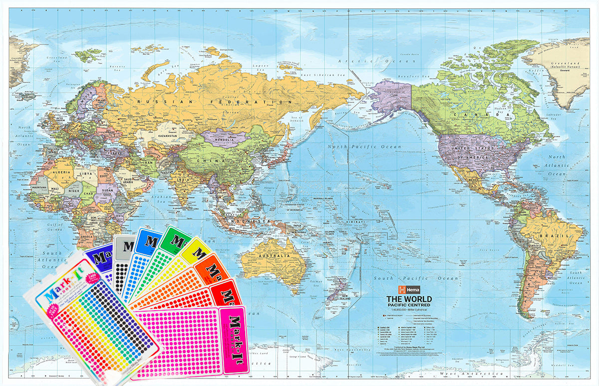
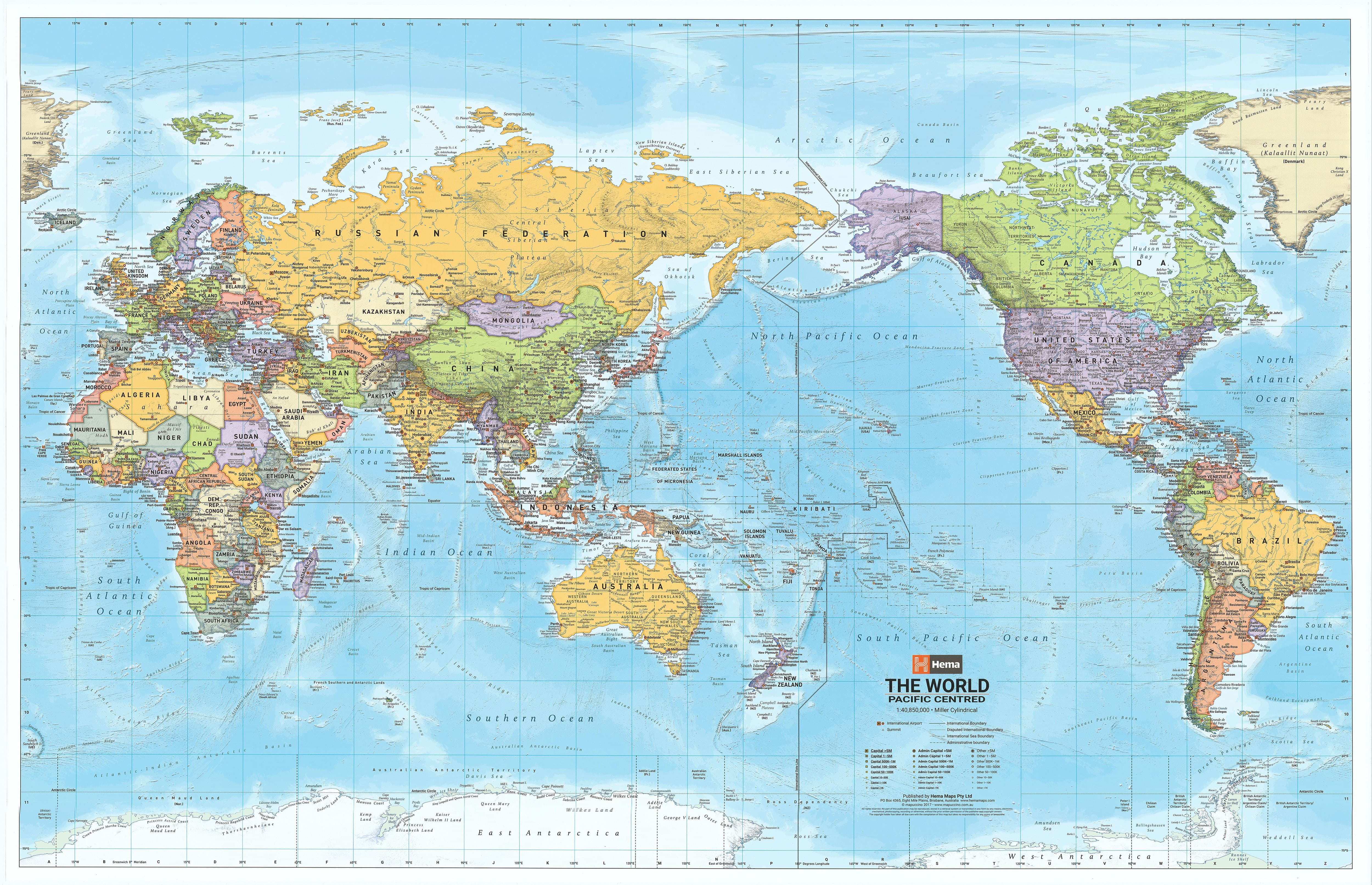
World Hema Mega (Pacific) 2320 x 1511mm Wall Map with FREE Map Dots
$295.00
or make 4 interest-free payments of
$73.75 AUD
fortnightly with
![]() More info
More info
A breathtakingly expansive, beautifully designed world map that places Australia and the Pacific where they belong – at the centre of it all.
The World Political Mega Map (Pacific-Centred) by Hema Maps is one of the largest, most detailed and visually engaging world maps available for wall display. Spanning an impressive 2.32 metres wide by 1.46 metres high, this single-sheet map is not only a practical geographic reference but also a striking visual centrepiece. Designed and printed in Australia, it caters to classrooms, corporate spaces, travel agencies, libraries, or anyone seeking a bold and informative view of the modern world.
Unlike conventional Atlantic-centred maps, this Pacific-centred projection reorients global geography to reflect an Asia-Pacific perspective. It’s the perfect layout for Australians, New Zealanders, and Pacific Rim nations, offering a more intuitive understanding of global relationships from our vantage point.
🌍 Key Features at a Glance
-
Projection: Pacific-centred — with the Americas on the far right and Africa/Europe on the far left, placing Oceania at the heart of the map.
-
Scale: 1:18,000,000 — large enough to provide global context with excellent political clarity.
-
Political Boundaries: Shows international borders, country names, capital cities, and major geographic regions.
-
Pastel Colour Coding: Each country is shaded with subtle, elegant pastels for clear differentiation without overwhelming the eye.
-
Ocean Bathymetry: Deep oceanic zones are rendered in rich blues with shading that reveals undersea ridges, trenches, and plateaus — ideal for teaching about tectonics and maritime geography.
🧭 Functional and Durable
Printed on demand using state-of-the-art digital printing technology, the map is made with 120 gsm FSC-certified matte-coated paper and encapsulated between two 80-micron sheets of gloss laminate. This results in a long-lasting, presentation-quality finish that is:
-
Waterproof and tear-resistant
-
Suitable for whiteboard markers (draw and wipe)
-
Ideal for Map Dots, pins, and interactive use
-
Protected against scuffing, stains, and fading
Perfect for high-use settings such as classrooms, planning rooms, or communal offices.
🎯 Ideal For:
-
Schools & Universities: A brilliant visual learning aid for geography, history, and global studies.
-
Corporate Offices & Boardrooms: Supports international business operations, logistics planning, and global strategy.
-
Travel Agencies & Tour Operators: Visually compelling for client engagement and destination plotting.
-
Libraries, Museums & Visitor Centres: Educational and decorative, showcasing the world's political landscape.
-
Home Study or Children’s Rooms: Inspires curiosity and learning in a large, easy-to-read format.
🧷 Mounting & Display Options
Want to display your map with elegance and ease? Opt for wooden hang rails:
-
Natural timber finish, top and bottom
-
Corded hanger attached to the top rail for simple wall mounting
-
Keeps the map flat and professional in appearance
-
Please allow an additional 10 working days if you select this option, as the hangers are custom-attached by our framer
🟢 BONUS: FREE Mark-It-Dots
Each Mega Map includes a complimentary set of Mark-It-Dots — multicoloured, removable, and specially designed to adhere without damaging the laminate.
-
Use to highlight:
-
Countries visited
-
Places of interest
-
Global operations or client bases
-
-
Set includes 8 assorted colours
-
Dots are 6mm in diameter — small enough for detail, bold enough to stand out
-
Shipped separately from our shop
📦 Product & Delivery Details
-
Size: 2320 mm (W) x 1460 mm (H)
-
Scale: 1:18,000,000
-
Finish: Gloss-laminated (encapsulated)
-
Edition: Print-on-demand, using the latest Hema world data
-
Printed in: Australia
-
Delivery:
-
Rolled and shipped in a sturdy protective tube
-
Courier delivery only (no PO Boxes, due to oversized dimensions)
-
Please allow up to 10 working days for printing and processing
-
Not available for international shipping
-
Why Pacific-Centred?
Most traditional world maps place Europe or North America at the centre. This map reflects the growing geopolitical and economic importance of the Asia-Pacific region, giving Australians and New Zealanders a more relevant and balanced global view. It’s also an excellent tool for visualising time zones, air routes, and trade flows from our hemisphere.
See the world the way we live in it.
With its immersive scale, exceptional clarity, and smart design, the Hema World Political (Pacific-Centred) Mega Map transforms walls into a portal to global understanding.
Big in scale. Bold in detail. Proudly Australian.


