- Australia ▾
- Topographic
▾
- Australia AUSTopo 250k (2025)
- Australia 50k Geoscience maps
- Australia 100k Geoscience maps
- Australia 250k Geoscience maps
- Australia 1:1m Geoscience maps
- New Zealand 50k maps
- New Zealand 250k maps
- New South Wales 25k maps
- New South Wales 50k maps
- New South Wales 100k maps
- Queensland 10k maps
- Queensland 25k maps
- Queensland 50k maps
- Queensland 100k maps
- Compasses
- Software
- GPS Systems
- Orienteering
- International ▾
- Wall Maps
▾
- World
- Australia & New Zealand
- Countries, Continents & Regions
- Historical
- Vintage National Geographic
- Australian Capital Territory
- New South Wales
- Northern Territory
- Queensland
- South Australia
- Tasmania
- Victoria
- Western Australia
- Celestial
- Children's
- Mining & Resources
- Wine Maps
- Healthcare
- Postcode Maps
- Electoral Maps
- Nautical ▾
- Flags
▾
- Australian Flag Sets & Banners
- Flag Bunting
- Handwavers
- Australian National Flags
- Aboriginal Flags
- Torres Strait Islander Flags
- International Flags
- Flagpoles & Accessories
- Australian Capital Territory Flags
- New South Wales Flags
- Northern Territory Flags
- Queensland Flags
- South Australia Flags
- Tasmania Flags
- Victoria Flags
- Western Australia Flags
- Gifts ▾
- Globes ▾
Dear valued customer. Please note that our checkout is not supported by old browsers. Please use a recent browser to access all checkout capabilities
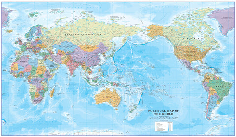
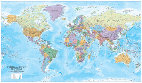
World Decorator National Geographic 1166 x 773mm Wall Map
$89.95
or make 4 interest-free payments of
$22.49 AUD
fortnightly with
![]() More info
More info
🌍 World Decorator – National Geographic Wall Map
Dimensions: 1166 mm (W) × 773 mm (H) | Scale: 1:29,802,000
Projection: Winkel Tripel | Made in Australia | Published: 2016
Available Finishes: Paper • Laminated • Laminated with Hang Rails • Canvas • Canvas with Hang Rails
✨ A World Map that Inspires and Informs
The National Geographic World Decorator Map is more than just a reference tool—it’s an artwork steeped in precision, beauty, and authority. Developed using multiple authoritative sources and shaped by National Geographic’s independent, apolitical editorial process, it is trusted by educators, professionals, and travellers across the globe.
Presented in the Decorator style, this map features vivid country colours that make borders instantly recognisable and learning intuitive. Every mountain range, valley, desert, and ocean depth is brought to life with shaded relief that captures the natural beauty of our planet’s surface. It is as visually stunning as it is geographically accurate.
Whether hung in a study, classroom, corporate boardroom, or family living space, it adds sophistication while sparking curiosity about the world.
📌 Key Cartographic Features
-
Vivid, Distinct Country Colours – Easy for students and professionals to read at a glance.
-
Shaded Relief Rendering – Adds depth and realism to the Earth’s landscapes.
-
Winkel Tripel Projection – Reduces size and shape distortion for a more truthful representation of the world.
-
Accurate Landmass Proportions – Greenland appears in correct proportion to South America, avoiding the distortions common in other projections.
-
Thousands of Place Names – Legibly placed to avoid crowding, even in dense regions like Europe and Asia.
-
Detailed Geographic Elements – International boundaries, capitals, major cities, rivers, mountain ranges, ocean trenches, and ridges.
-
Inset Maps – Vegetation & Land Use, Population Density, and Polar Regions for broader context.
🖼 Premium Finish & Display Options
📄 Premium 160gsm FSC Paper
-
Smooth matte surface ideal for framing under glass.
-
Crisp print quality with fine detail and colour fidelity.
-
Ships rolled in a heavy-duty mailing tube for protection.
💧 Encapsulated Gloss Laminate
-
Fully sealed between two 80-micron gloss layers.
-
Waterproof, UV-resistant, and tear-resistant.
-
Can be marked with whiteboard markers and cleaned without damage—perfect for schools and offices.
🪵 Laminated with Timber Hang Rails
-
Adds instant elegance with natural lacquered timber battens at the top and bottom.
-
Includes an attached cord for easy single-hook display—no framing required.
-
Ideal for those who want their map ready to hang straight away.
🎨 395gsm HP Professional Matte Canvas
-
Museum-grade texture with fade-resistant pigment inks.
-
Rich, deep colour tones with exceptional longevity.
-
Flexible for framing, stretching, or displaying as-is for a gallery-style look.
🪵 Canvas with Timber Hang Rails
-
Combines the tactile luxury of canvas with the convenience of ready-to-hang rails.
-
Lacquered natural timber finish for timeless presentation.
Note: Please allow up to 10 working days for hang-railed versions, as these are hand-mounted by our professional framer.
📏 Specifications
| Feature | Details |
|---|---|
| Publisher | National Geographic Society |
| Style | Decorator – vibrant country colours |
| Projection | Winkel Tripel |
| Inset Maps | Vegetation & Land Use, Population Density, North & South Polar Regions |
| Scale | 1:29,802,000 |
| Dimensions | 1166 mm (W) × 773 mm (H) |
| Finishes | Paper, Laminated, Laminated with Hang Rails, Canvas, Canvas with Hang Rails |
| Printed In | Australia |
| Edition | 2016 |
🎯 Who Is This Map For?
✔️ Educators – Clear, engaging visuals make it an exceptional teaching aid for geography, social studies, or environmental science.
✔️ Corporate Offices – Elevates meeting rooms with a sophisticated yet informative statement piece.
✔️ Home Study or Library – Adds both intellectual and decorative value.
✔️ Travel Enthusiasts – Perfect for tracking past journeys and planning future adventures.
✔️ Gift Buyers – An unforgettable present for map lovers, students, or newlyweds setting out on life’s adventures.
🌟 Why Choose National Geographic?
For over 130 years, National Geographic has set the benchmark for cartographic quality. This map embodies their tradition of combining scientific authority with artistic presentation, creating pieces that last for generations.
The World Decorator Map is more than just a way to view our planet—it’s a window into the interconnectedness of places, cultures, and people. Its balance of vibrant colour and topographic detail makes it both a learning resource and a timeless decorative feature.
📦 Delivery & Care
-
Maps are shipped in protective mailing tubes.
-
Laminated and canvas versions are easy to clean and maintain.
-
Hang rail versions are delivered ready to display.
-
Australia-wide delivery with international shipping available upon request.


