- Australia ▾
- Topographic
▾
- Australia AUSTopo 250k (2024)
- Australia 50k Geoscience maps
- Australia 100k Geoscience maps
- Australia 250k Geoscience maps
- Australia 1.1m Geoscience maps
- New Zealand 50k maps
- New Zealand 250k maps
- New South Wales 25k maps
- New South Wales 50k maps
- New South Wales 100k maps
- Queensland 10k maps
- Queensland 25k maps
- Queensland 50k maps
- Queensland 100k maps
- Compasses
- Software
- GPS Systems
- Orienteering
- International ▾
- Wall Maps
▾
- World
- Australia & New Zealand
- Countries, Continents & Regions
- Historical
- Vintage National Geographic
- Australian Capital Territory
- New South Wales
- Northern Territory
- Queensland
- South Australia
- Tasmania
- Victoria
- Western Australia
- Celestial
- Children's
- Mining & Resources
- Wine Maps
- Healthcare
- Postcode Maps
- Electoral Maps
- Nautical ▾
- Flags
▾
- Australian Flag Sets & Banners
- Flag Bunting
- Handwavers
- Australian National Flags
- Aboriginal Flags
- Torres Strait Islander Flags
- International Flags
- Flagpoles & Accessories
- Australian Capital Territory Flags
- New South Wales Flags
- Northern Territory Flags
- Queensland Flags
- South Australia Flags
- Tasmania Flags
- Victoria Flags
- Western Australia Flags
- Gifts ▾
- Globes ▾
Dear valued customer. Please note that our checkout is not supported by old browsers. Please use a recent browser to access all checkout capabilities
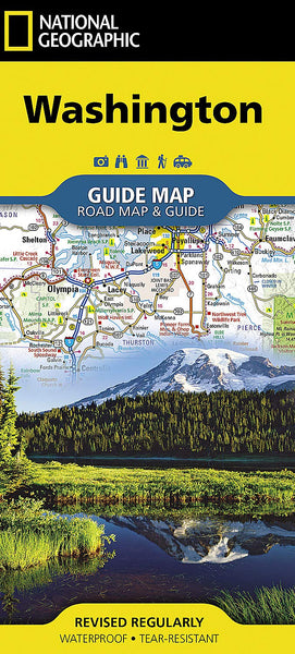
Washington State National Geographic Folded Map
$29.95
Afterpay is only available for orders between $50.00 and $1000.00 More info
Washington State – National Geographic Guide Map
Waterproof • Tear-Resistant • Travel Map
From the snow-capped peaks of Mount Rainier to the wild Pacific coast, National Geographic’s Washington State Guide Map is your essential travel companion. Combining precise cartography with in-depth travel information, it’s designed for road trippers, hikers, outdoor enthusiasts, and anyone eager to explore the Evergreen State.
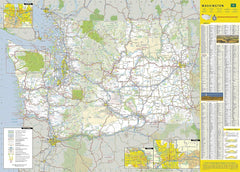
📍 Complete Statewide Coverage
-
Full Road Network – Interstates, U.S. and state highways, tollways, scenic byways, and secondary roads clearly marked
-
Mileage Indicators – Distances in miles shown on major highways for efficient route planning
-
Points of Interest – National and state parks, public campsites, visitor centres, airports, ski areas, ports of entry, and more
-
Topographic Features – Mountains, rivers, and coastal areas highlighted for outdoor navigation
🗺 Insets & Special Features
-
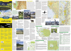
City Insets – Olympia, Yakima, Spokane, and Seattle with detailed street mapping
-
National Park Focus – Olympic, Mount Rainier, and North Cascades National Parks highlighted with maps, visitor notes, and key attractions
-
Scenic Drive Spotlight – Mount Adams Scenic Drive mapped with recommended stops
-
Travel Tools – Park service site chart, climate data, and recreational planning tips
📖 Travel-Friendly Design
-
User-Friendly Index – Quickly locate towns, cities, and landmarks
-
Durable Material – Printed on waterproof, tear-resistant synthetic paper
-
Compact Portability – Folds neatly for glove box, backpack, or jacket pocket storage
📐 Product Specifications
| Feature | Detail |
|---|---|
| Publisher | National Geographic Maps |
| Map Type | Folded State Guide Map |
| Material | Waterproof, tear-resistant synthetic paper |
| Format | Double-sided |
| Flat Size | 660 mm x 940 mm (26" x 37") |
| Folded Size | 102 mm x 229 mm (4" x 9") |
| Order Info | Order on Demand – Please allow 7–10 working days for delivery |
🎯 Perfect For
-
Road trippers exploring Washington’s mountains, coastlines, and wine country
-
Hikers & campers visiting Olympic, Mount Rainier, and North Cascades
-
Photographers chasing waterfalls, alpine lakes, and dramatic coastal views
-
History & culture enthusiasts following heritage trails and city highlights
-
Educators & students needing an accurate, up-to-date geographic reference
With National Geographic’s Washington State Guide Map, you’ll have a reliable, rugged, and beautifully detailed resource—ready to guide you from Seattle’s waterfront to the peaks of the Cascades and every adventure in between.


