- Australia ▾
- Topographic
▾
- Australia AUSTopo 250k (2025)
- Australia 50k Geoscience maps
- Australia 100k Geoscience maps
- Australia 250k Geoscience maps
- Australia 1:1m Geoscience maps
- New Zealand 50k maps
- New Zealand 250k maps
- New South Wales 25k maps
- New South Wales 50k maps
- New South Wales 100k maps
- Queensland 10k maps
- Queensland 25k maps
- Queensland 50k maps
- Queensland 100k maps
- Compasses
- Software
- GPS Systems
- Orienteering
- International ▾
- Wall Maps
▾
- World
- Australia & New Zealand
- Countries, Continents & Regions
- Historical
- Vintage National Geographic
- Australian Capital Territory
- New South Wales
- Northern Territory
- Queensland
- South Australia
- Tasmania
- Victoria
- Western Australia
- Celestial
- Children's
- Mining & Resources
- Wine Maps
- Healthcare
- Postcode Maps
- Electoral Maps
- Nautical ▾
- Flags
▾
- Australian Flag Sets & Banners
- Flag Bunting
- Handwavers
- Australian National Flags
- Aboriginal Flags
- Torres Strait Islander Flags
- International Flags
- Flagpoles & Accessories
- Australian Capital Territory Flags
- New South Wales Flags
- Northern Territory Flags
- Queensland Flags
- South Australia Flags
- Tasmania Flags
- Victoria Flags
- Western Australia Flags
- Gifts ▾
- Globes ▾
Dear valued customer. Please note that our checkout is not supported by old browsers. Please use a recent browser to access all checkout capabilities


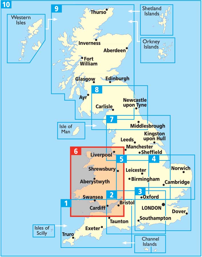
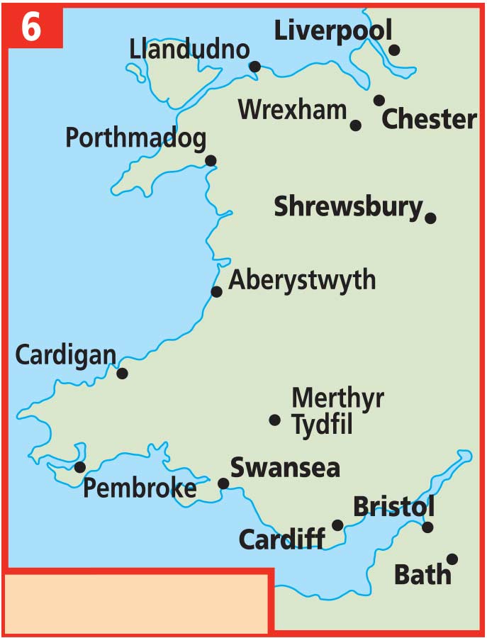
Wales AA Road Map 6
$19.95
Afterpay is only available for orders between $50.00 and $1000.00 More info
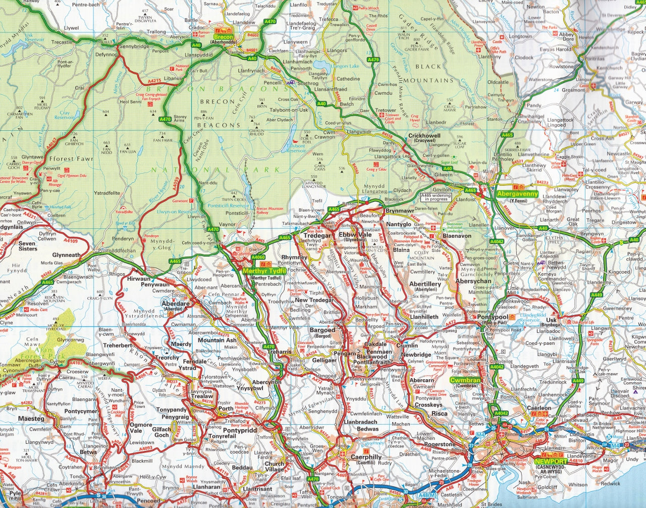
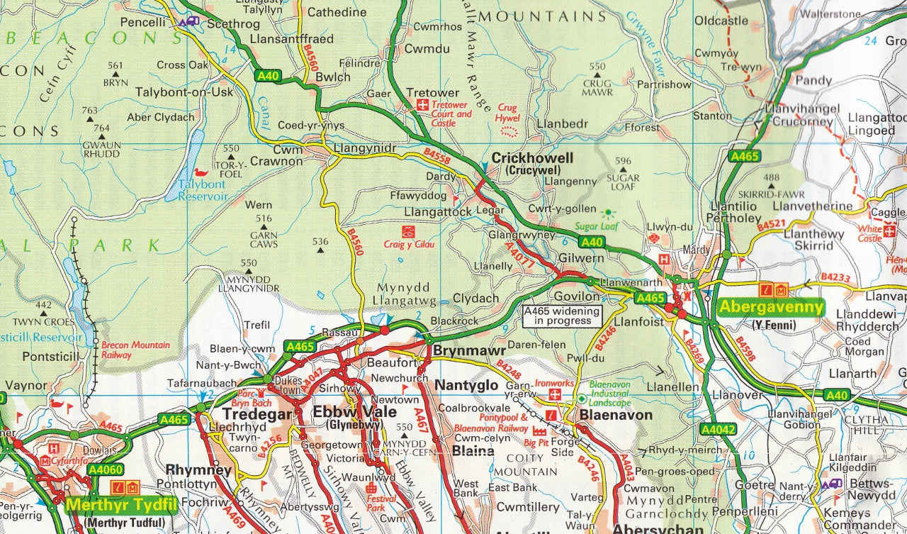
Folded Road Map by the Automobile Association (AA)
Scale: 1:250,000 | Size: 1200 mm x 980 mm | Format: Folded Paper
Whether you’re navigating the dramatic cliffs of Pembrokeshire, weaving through the misty valleys of Snowdonia, or heading for a long weekend in Cardiff, the AA Road Map of Wales is your ultimate glovebox companion. Produced by Britain’s most trusted motoring authority, this detailed, user-friendly map is designed to guide you through every bend, detour, and hidden gem the country has to offer.
🛣️ Mapping You Can Trust
With a generous scale of 1:250,000 (4 miles to 1 inch), this easy-to-read map provides clarity and precision for both long-distance travel and local detours. The cartography is crisp, the colour palette intuitive, and the symbols clearly defined—whether you're on a major motorway or a narrow country lane.
The map includes the most up-to-date road information available, with:
-
Motorways and dual carriageways clearly distinguished
-
Road numbers for quick navigation
-
Toll points and service areas shown for strategic pitstops
-
Minor roads and lanes included for scenic or rural travel
-
Speed camera locations, with many displaying the actual speed limit
🏕️ Touring Essentials at a Glance
This map is more than just roads—it’s an all-in-one touring tool. Points of interest, natural landmarks, and visitor facilities are flagged throughout the map for effortless holiday planning. Whether you’re chasing waterfalls or plotting pub lunches, you’ll appreciate:
-
Caravan and camping sites pinpointed on the map
-
National Parks and designated scenic routes
-
Tourist attractions such as castles, gardens, and museums
-
National Trust, English Heritage, and Welsh Heritage properties all clearly marked
🏙️ Urban Navigation Made Simple
To help you navigate built-up areas and plan urban outings, the map includes detailed city and town centre insets, each highlighting road networks, key landmarks, and major transport links. Included city plans:
-
Cardiff
-
Swansea
-
Aberystwyth
-
Liverpool
-
Chester
-
Shrewsbury
-
Llandudno
-
Bristol
These maps are ideal for locating parking areas, public transport hubs, and central attractions.
📚 Comprehensive Indexing & Reference Tools
Finding your destination is fast and straightforward thanks to a full place-name index, printed in a large, readable font and easy to navigate. Whether you're headed to a well-known city or a quiet village, this index will get you there without fuss.
💡 Added Features
-
Encased in a weatherproof protective sleeve for durability on the road
-
Compact and easy to fold—perfect for storing in your glovebox, backpack, or map pocket
-
Includes symbol keys and road legend in multiple languages for international travellers
-
Designed to work alongside sat-navs or GPS as a trusted offline backup
🧭 Who This Map is For:
-
Holidaymakers exploring by car or caravan
-
Business travellers needing a reliable planning tool
-
Delivery drivers and couriers working across Wales
-
Outdoor adventurers seeking the lay of the land
-
Locals and expats reconnecting with the regions
Whether you’re a seasoned traveller or visiting for the first time, the AA’s Wales Road Map is a smart, affordable investment in smooth, informed, and enjoyable travel.
🗂️ Specifications:
-
Scale: 1:250,000 (4 miles to 1 inch / 2.5 km to 1 cm)
-
Size (unfolded): 1200 mm x 980 mm
-
Format: Folded paper map
-
Publisher: The AA (Automobile Association)
-
Publication Year: Latest available edition
🧳 Travel smart. Stay on course. Discover Wales the way it was meant to be seen—on the road.
Frequently Asked Questions
What area does the Wales AA Road Map 6 cover?
The Wales AA Road Map 6 provides road coverage of the region named in the product title. The map covers major cities, highways, towns, and regional roads, with inset city maps for key urban centres where applicable.
Is the Wales AA Road Map 6 up to date?
Yes, this is the current edition. Mapworld stocks the most current editions from all major publishers, updated to reflect new roads and infrastructure.
What size is this map when unfolded?
Folded maps from Mapworld's range are compact and portable. Most standard folded road or travel maps open to between A1 (594 × 841mm) and A0 (841 × 1189mm) when fully unfolded, and fold down to approximately A4 or smaller for easy storage in a glove box, bag, or backpack.
Is the Wales AA Road Map 6 in stock at Mapworld?
Mapworld maintains extensive stock across its map range and aims for fast dispatch. Orders placed before 2pm AEST on business days are typically dispatched the same day, with standard and express Australia-wide delivery options available.
Does Mapworld ship the Wales AA Road Map 6 across Australia?
Yes, Mapworld ships Australia-wide. Standard shipping is a flat $7 rate, with free standard shipping on orders over $75. Express options are available at checkout. Most orders placed before 2pm AEST on weekdays are dispatched same day.
Related Items


© 2026 Mapworld. Website designed by Genie Media
X