- Australia ▾
- Topographic
▾
- Australia AUSTopo 250k (2025)
- Australia 50k Geoscience maps
- Australia 100k Geoscience maps
- Australia 250k Geoscience maps
- Australia 1:1m Geoscience maps
- New Zealand 50k maps
- New Zealand 250k maps
- New South Wales 25k maps
- New South Wales 50k maps
- New South Wales 100k maps
- Queensland 10k maps
- Queensland 25k maps
- Queensland 50k maps
- Queensland 100k maps
- Western Australia 25k maps
- Western Australia 50k maps
- Western Australia 100k maps
- Compasses
- Software
- GPS Systems
- International ▾
- Wall Maps
▾
- World
- Australia & New Zealand
- Countries, Continents & Regions
- Historical
- Vintage National Geographic
- Australian Capital Territory
- New South Wales
- Northern Territory
- Queensland
- South Australia
- Tasmania
- Victoria
- Western Australia
- Celestial
- Children's
- Mining & Resources
- Wine Maps
- Healthcare
- Postcode Maps
- Electoral Maps
- Nautical ▾
- Flags
▾
- Australian Flag Sets & Banners
- Flag Bunting
- Handwavers
- Australian National Flags
- Aboriginal Flags
- Torres Strait Islander Flags
- International Flags
- Flagpoles & Accessories
- Australian Capital Territory Flags
- New South Wales Flags
- Northern Territory Flags
- Queensland Flags
- South Australia Flags
- Tasmania Flags
- Victoria Flags
- Western Australia Flags
- Gifts ▾
- Globes ▾
Dear valued customer. Please note that our checkout is not supported by old browsers. Please use a recent browser to access all checkout capabilities


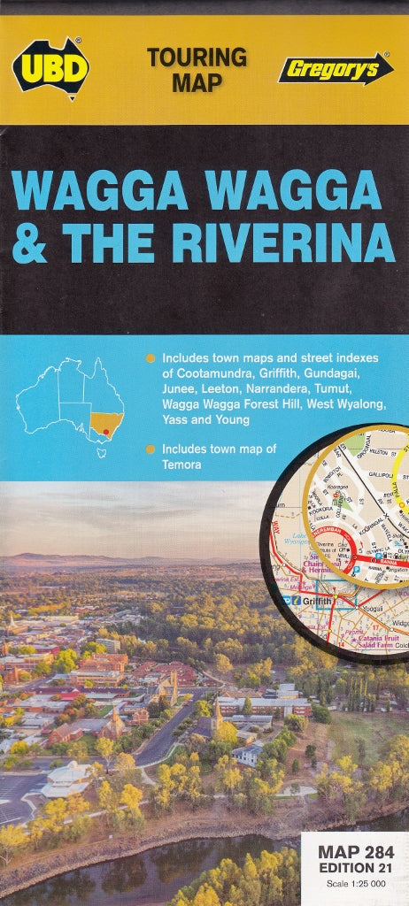
Wagga Wagga & Riverina UBD Map 284
$13.95
Afterpay is only available for orders between $50.00 and $1000.00 More info
Scale: 1:250,000 | Size: 700 mm x 1000 mm | Laminated Option Available
The Ideal Blend of Regional Coverage & Street-Level Detail for Exploring NSW’s Heartland
Discover the charm and character of New South Wales' Riverina region with the Wagga Wagga & Riverina Touring Map by UBD Gregory’s. Whether you're road-tripping through regional towns or navigating city streets, this detailed map combines broad touring coverage with localised street mapping, making it an essential tool for travellers, locals, and business operators alike.
✅ Key Features
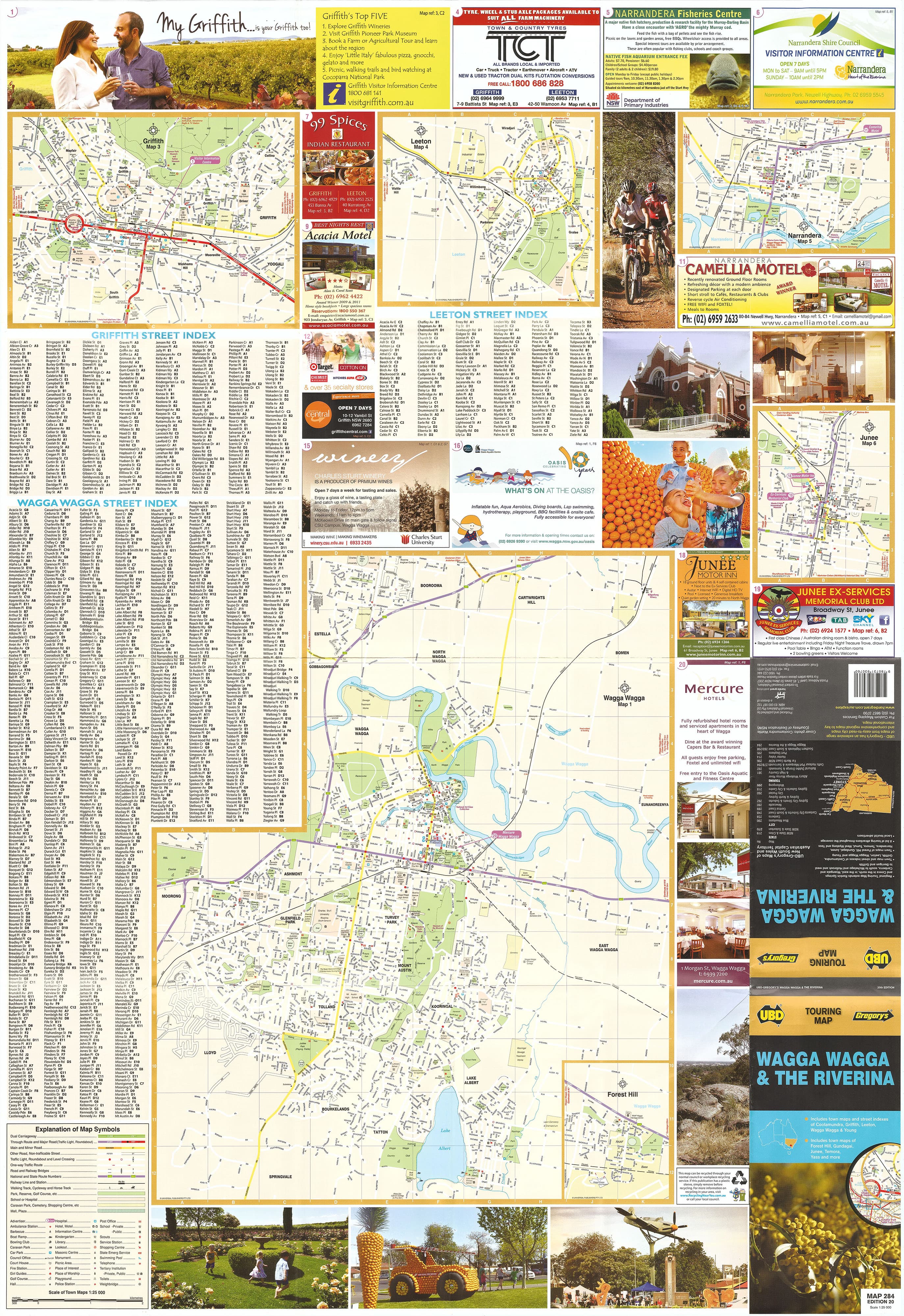
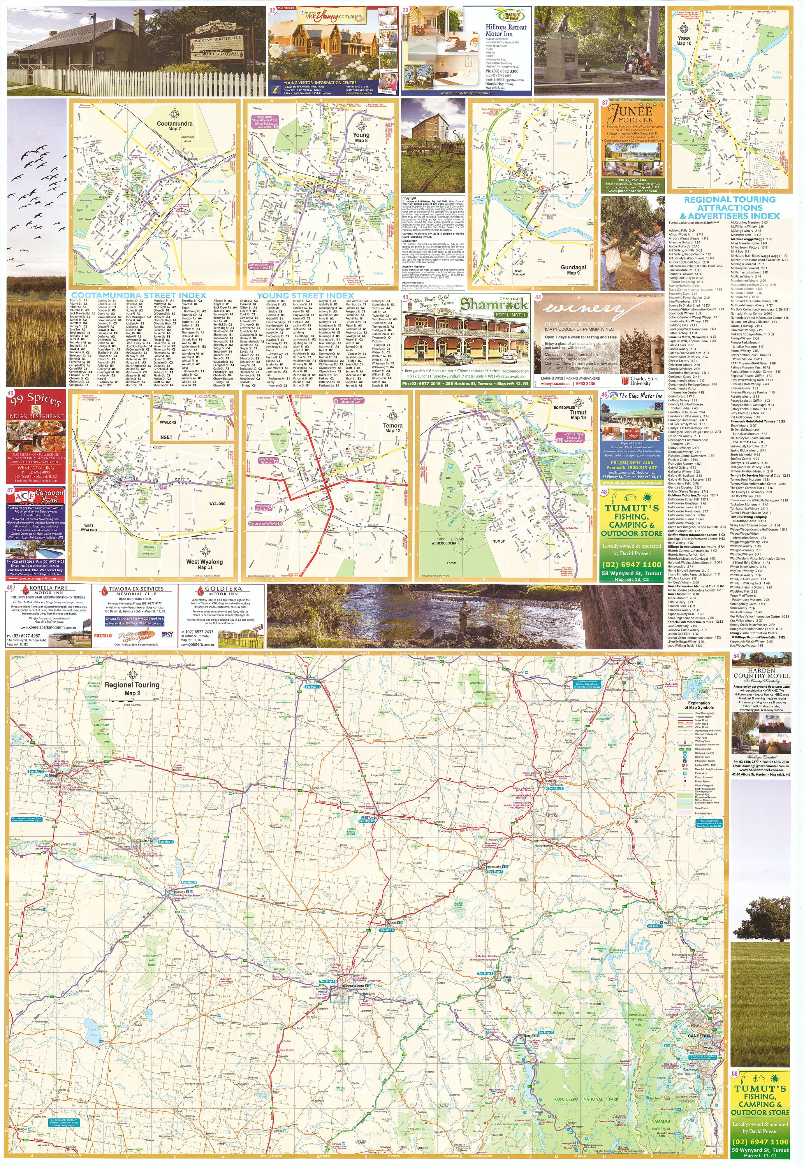
Town Maps with Street Indexes
Includes detailed maps and street indexes for major regional centres:
-
Wagga Wagga
-
Griffith
-
Leeton
-
Cootamundra
-
Young
Additional Town Maps
Also features street-level mapping for:
-
Gundagai
-
Junee
-
Narrandera
-
Temora
-
Tumut
-
West Wyalong
-
Yass Town
Touring & Local Information
Highlights:
-
Tourist attractions
-
Points of interest
-
Local services and business listings
Perfect for planning day trips, business travel, or exploring new regions.
Combination of Regional & Local Mapping
With both 1:250,000 scale regional mapping and detailed town layouts, this map allows for seamless navigation across highways, country roads, and suburban streets.
Laminated Version Available
📌 Upgrade to Laminated for Durability
-
Write-on/wipe-off surface for whiteboard markers
-
Compatible with map dots—ideal for marking towns visited or route planning
-
Tear-resistant and stain-resistant, great for frequent use in vehicles or on the go
Laminated maps are flattened from their folded format and encapsulated in 80-micron gloss laminate. Some minor fold lines may remain but won’t affect clarity or performance.
Product Specifications
| Feature | Details |
|---|---|
| Publisher | UBD Gregory’s |
| Map Title | Wagga Wagga & Riverina Touring Map (Map 284) |
| Scale | 1:250,000 (Regional coverage) |
| Size (Unfolded) | 700 mm x 1000 mm |
| Format | Folded paper map or laminated version (optional) |
| Features Included | Street maps, town indexes, regional roads, tourist information |
Perfect For:
✔️ Tourists & regional travellers exploring Riverina towns and landscapes
✔️ Delivery drivers and business reps navigating regional service areas
✔️ Local councils & visitor centres needing reliable wall references
✔️ Educators, planners, and real estate professionals
✔️ Families planning road trips through southern NSW
From the Murrumbidgee to the Snowy Valleys, the Wagga Wagga & Riverina Touring Map delivers reliable coverage of one of NSW’s most dynamic regions. Whether you're visiting wineries in Griffith, exploring colonial heritage in Gundagai, or heading to the Tumut River, this map has you covered—street by street, town by town.
🛒 Add to Cart Today – and choose the laminated version for a durable, markable companion on your next regional journey.
Frequently Asked Questions
Where can I buy the Wagga Wagga & Riverina UBD Map 284?
The Wagga Wagga & Riverina UBD Map 284 is available to buy online from Mapworld, Australia's largest map and geographic product retailer, with fast shipping Australia-wide.
Is the Wagga Wagga & Riverina UBD Map 284 in stock at Mapworld?
Mapworld maintains extensive stock across its map range and aims for fast dispatch. Orders placed before 2pm AEST on business days are typically dispatched the same day, with standard and express Australia-wide delivery options available.
What is Mapworld's returns policy?
Mapworld accepts returns on undamaged items in original condition. Contact Mapworld within 90 days of purchase to arrange a return or exchange.
Does Mapworld ship the Wagga Wagga & Riverina UBD Map 284 across Australia?
Yes, Mapworld ships Australia-wide. Standard shipping is a flat $7 rate, with free standard shipping on orders over $75. Express options are available at checkout. Most orders placed before 2pm AEST on weekdays are dispatched same day.
Related Items


© 2026 Mapworld. Website designed by Genie Media
X