- Australia ▾
- Topographic
▾
- Australia AUSTopo 250k (2025)
- Australia 50k Geoscience maps
- Australia 100k Geoscience maps
- Australia 250k Geoscience maps
- Australia 1:1m Geoscience maps
- New Zealand 50k maps
- New Zealand 250k maps
- New South Wales 25k maps
- New South Wales 50k maps
- New South Wales 100k maps
- Queensland 10k maps
- Queensland 25k maps
- Queensland 50k maps
- Queensland 100k maps
- Western Australia 25k maps
- Western Australia 50k maps
- Western Australia 100k maps
- Compasses
- Software
- GPS Systems
- International ▾
- Wall Maps
▾
- World
- Australia & New Zealand
- Countries, Continents & Regions
- Historical
- Vintage National Geographic
- Australian Capital Territory
- New South Wales
- Northern Territory
- Queensland
- South Australia
- Tasmania
- Victoria
- Western Australia
- Celestial
- Children's
- Mining & Resources
- Wine Maps
- Healthcare
- Postcode Maps
- Electoral Maps
- Nautical ▾
- Flags
▾
- Australian Flag Sets & Banners
- Flag Bunting
- Handwavers
- Australian National Flags
- Aboriginal Flags
- Torres Strait Islander Flags
- International Flags
- Flagpoles & Accessories
- Australian Capital Territory Flags
- New South Wales Flags
- Northern Territory Flags
- Queensland Flags
- South Australia Flags
- Tasmania Flags
- Victoria Flags
- Western Australia Flags
- Gifts ▾
- Globes ▾
Dear valued customer. Please note that our checkout is not supported by old browsers. Please use a recent browser to access all checkout capabilities


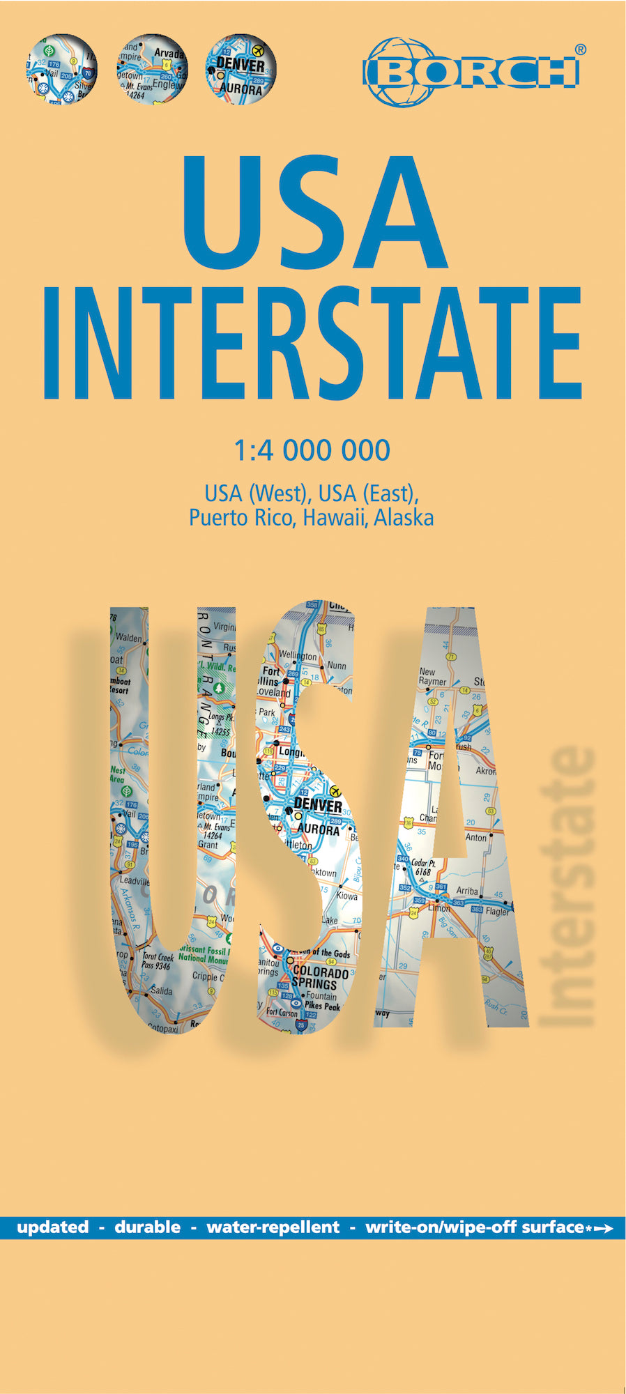
USA Interstate Borch Folded Laminated Map
$21.95
Afterpay is only available for orders between $50.00 and $1000.00 More info
Your Ultimate Road Companion Across America’s Legendary Interstate System
Hit the open road with confidence and style with this USA Interstate Borch Map, a durable, easy-to-use guide designed for every traveller navigating America’s vast and legendary interstate network. From coast to coast, border to border, this map makes planning your journey, finding attractions, and understanding the layout of the USA simpler than ever.
🗺️ Detailed Coverage & Smart Design
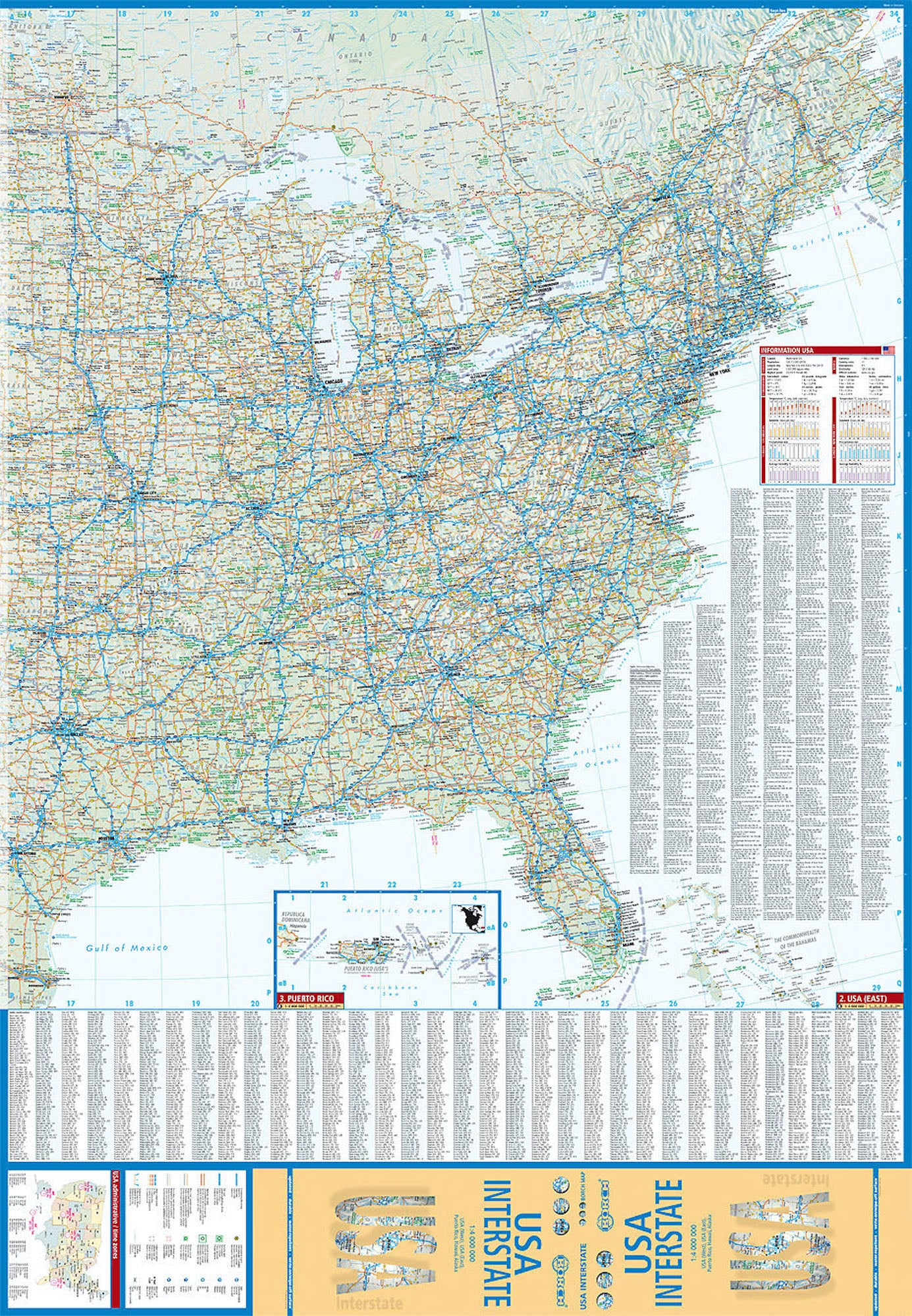
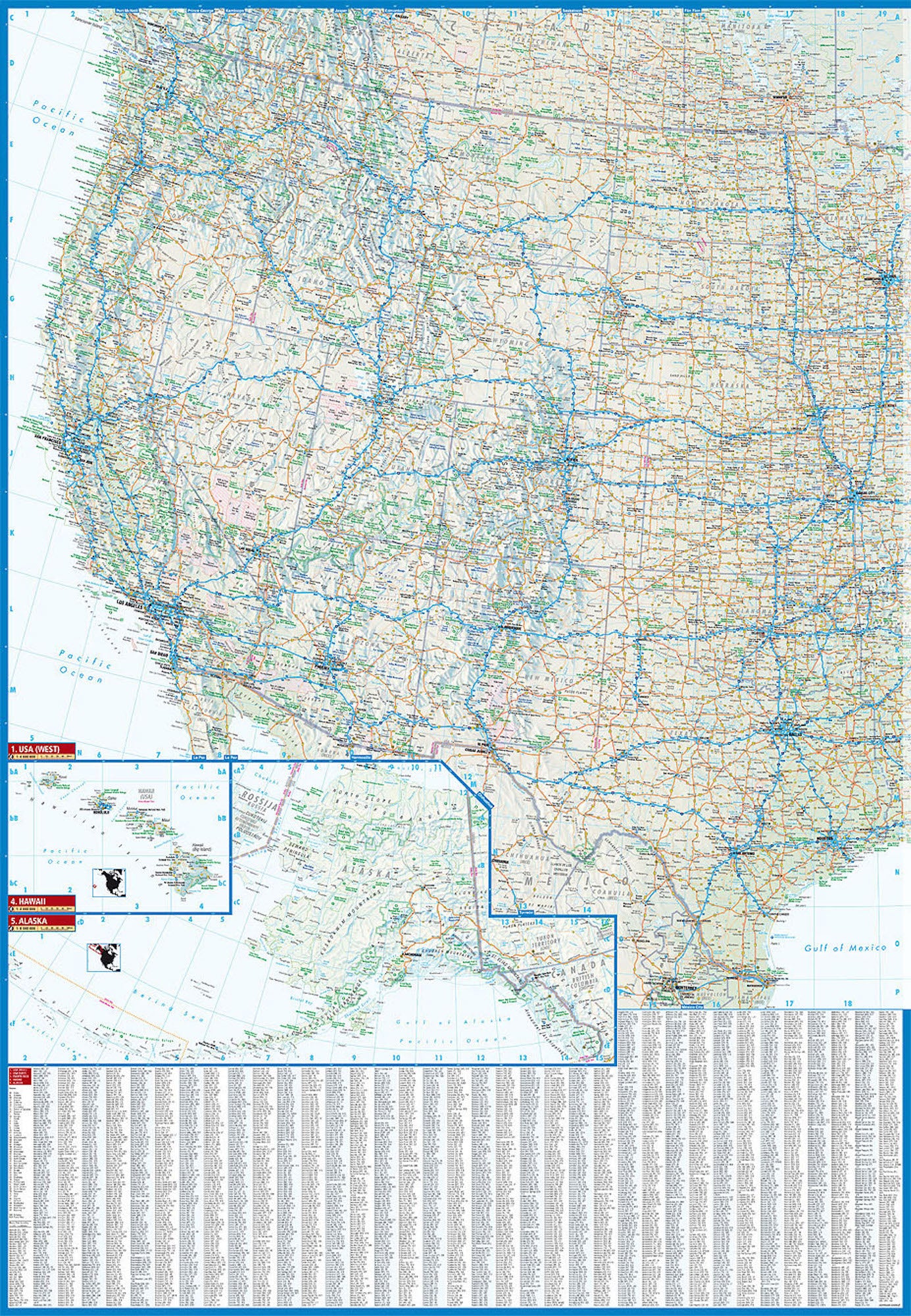
This 13th edition, soft-laminated and folded map includes:
-
USA West: Scale 1:4,000,000
-
USA East: Scale 1:4,000,000
-
Hawaiian Islands: Scale 1:4,000,000
-
Puerto Rico: Scale 1:4,000,000
-
Alaska: Scale 1:8,000,000
-
Administrative & Time Zones Map: Showing USA regions and current time zones across the country
Borch Maps are known for:
-
Exceptional readability and clarity
-
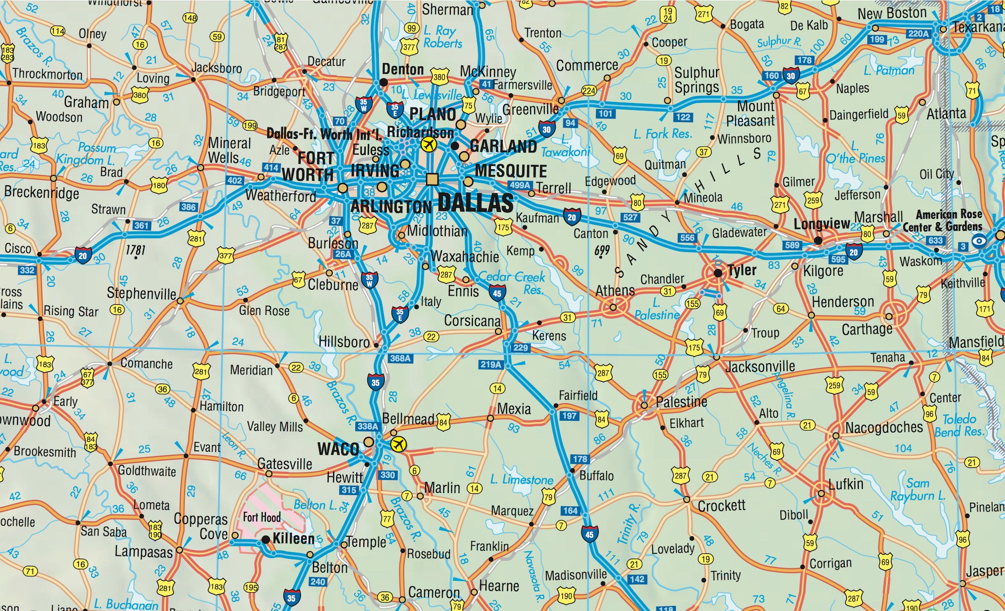
Up-to-date road networks, interstates, and highways
-
Helpful inset maps, climate charts, useful travel statistics, and conversion tables (temperature, weight, measurements)
-
Highlighted hotels, museums, monuments, markets, public transport, top sights, and points of interest
🛡️ Premium Quality & Durability
This map is soft-laminated, making it:
✔️ Durable: Resistant to tears, folds, and creases even with regular handling.
✔️ Water-repellent: Ideal for road trips, outdoor planning, or use in unpredictable weather.
✔️ Wipeable: Mark routes or notes with a dry-erase pen, then clean and reuse.
✔️ Compact: Folded design fits easily in gloveboxes, backpacks, or suitcases.
🚗 A Brief History of the Interstate
The modern USA interstate system—officially the Dwight D. Eisenhower National System of Interstate and Defense Highways—was born from the Federal Aid Highway Act of 1956. Inspired by the German Autobahn system, President Eisenhower envisioned an interconnected network to move goods, arms, and people swiftly across the nation in times of emergency. Today, with nearly 48,856 miles (77,017 km) of roadway, it’s the backbone of American road travel—connecting vacationers, commuters, and adventurers from every corner of the country.
📐 Specifications
| Attribute | Details |
|---|---|
| Title | USA Interstate Borch Folded Laminated Map |
| Scale | 1:4,000,000 (main USA maps), 1:8,000,000 (Alaska) |
| Edition | 13th (2017) |
| ISBN | 978-3-86609-367-6 |
| Size (unfolded) | 990 mm (W) x 685 mm (H) |
| Size (folded) | 243 mm (H) x 110 mm (W) x 10 mm (D) |
| Weight | 98 g (3.5 oz) |
| Material | Soft-laminated, folded map |
✅ Why Choose Borch Maps?
| Feature | Benefit |
|---|---|
| Soft-laminated design | Water-resistant, wipeable, durable |
| Compact & foldable | Perfect for travel and on-the-go use |
| Exceptional clarity | Easy to read, up-to-date, detailed |
| More than roads | Includes sights, statistics, climate charts, conversion tables, and more |
| Trusted globally | Used by travellers and professionals worldwide |
Get ready to "head out on the highway" with the ultimate USA Interstate map—order your Borch Folded Laminated Map today and travel America with confidence, clarity, and style!
Frequently Asked Questions
Where can I buy the USA Interstate Borch Folded Laminated Map?
The USA Interstate Borch Folded Laminated Map is available to buy online from Mapworld, Australia's largest map and geographic product retailer, with fast shipping Australia-wide.
Is the USA Interstate Borch Folded Laminated Map in stock at Mapworld?
Mapworld maintains extensive stock across its map range and aims for fast dispatch. Orders placed before 2pm AEST on business days are typically dispatched the same day, with standard and express Australia-wide delivery options available.
What is Mapworld's returns policy?
Mapworld accepts returns on undamaged items in original condition. Contact Mapworld within 90 days of purchase to arrange a return or exchange.
Does Mapworld ship the USA Interstate Borch Folded Laminated Map across Australia?
Yes, Mapworld ships Australia-wide. Standard shipping is a flat $7 rate, with free standard shipping on orders over $75. Express options are available at checkout. Most orders placed before 2pm AEST on weekdays are dispatched same day.
Related Items


© 2026 Mapworld. Website designed by Genie Media
X