- Australia ▾
- Topographic
▾
- Australia AUSTopo 250k (2024)
- Australia 50k Geoscience maps
- Australia 100k Geoscience maps
- Australia 250k Geoscience maps
- Australia 1.1m Geoscience maps
- New Zealand 50k maps
- New Zealand 250k maps
- New South Wales 25k maps
- New South Wales 50k maps
- New South Wales 100k maps
- Queensland 10k maps
- Queensland 25k maps
- Queensland 50k maps
- Queensland 100k maps
- Compasses
- Software
- GPS Systems
- Orienteering
- International ▾
- Wall Maps
▾
- World
- Australia & New Zealand
- Countries, Continents & Regions
- Historical
- Vintage National Geographic
- Australian Capital Territory
- New South Wales
- Northern Territory
- Queensland
- South Australia
- Tasmania
- Victoria
- Western Australia
- Celestial
- Children's
- Mining & Resources
- Wine Maps
- Healthcare
- Postcode Maps
- Electoral Maps
- Nautical ▾
- Flags
▾
- Australian Flag Sets & Banners
- Flag Bunting
- Handwavers
- Australian National Flags
- Aboriginal Flags
- Torres Strait Islander Flags
- International Flags
- Flagpoles & Accessories
- Australian Capital Territory Flags
- New South Wales Flags
- Northern Territory Flags
- Queensland Flags
- South Australia Flags
- Tasmania Flags
- Victoria Flags
- Western Australia Flags
- Gifts ▾
- Globes ▾
Dear valued customer. Please note that our checkout is not supported by old browsers. Please use a recent browser to access all checkout capabilities


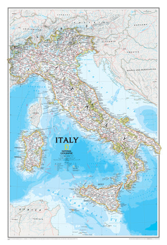
Tuscany National Geographic Folded Map
$26.95
Afterpay is only available for orders between $50.00 and $1000.00 More info
Folded Travel Map | Waterproof & Tear-Resistant | 965 x 660 mm
Discover Tuscany in Unrivalled Detail
Whether you're winding through Chianti’s vineyard-lined roads or exploring medieval hill towns under the Tuscan sun, the Tuscany Adventure Map by National Geographic is your perfect travel companion. Meticulously crafted for the adventurous traveller, this map blends rugged durability with detailed cartography to help you uncover every corner of this celebrated Italian region.
Designed for real-world use, this map is printed on durable, waterproof, and tear-resistant synthetic paper, ensuring it holds up through all your travels—from Florence’s cobbled laneways to the sun-drenched Tyrrhenian coastline.
🗺️ Key Features
| Attribute | Details |
|---|---|
| Publisher | National Geographic |
| Format | Folded Adventure Map (two-sided) |
| Material | Waterproof, tear-resistant synthetic paper |
| Folded Size | 235 mm (H) x 108 mm (W) |
| Unfolded Size | 965 mm (W) x 660 mm (H) |
| Map Coverage | Western & Eastern Tuscany, plus regional inset maps |
| Language | English (main), with multilingual legend |
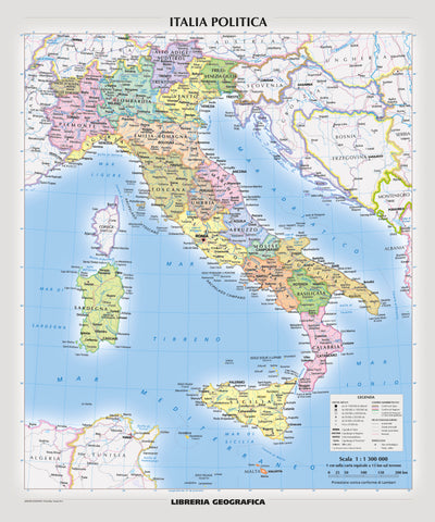
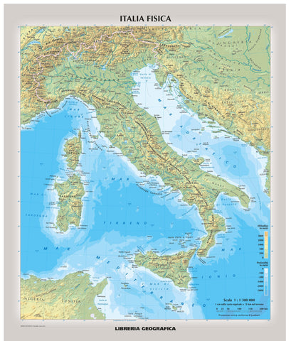
🧭 Coverage and Detail
Front Side – Western Tuscany
-
Coastline from the Ligurian to the Tyrrhenian Sea
-
Cities of Pisa and Livorno prominently marked
-
Major and minor roads, scenic byways, and coastal trails
-
Detailed inset of Arcipelago Toscano National Park (Tuscan Archipelago)
Reverse Side – Eastern Tuscany
-
Includes the cultural heart of Tuscany: Florence, Siena, Arezzo, and Grosseto
-
Coverage extends to Lake Trasimeno in neighbouring Umbria
-
Hilltop towns, natural reserves, and UNESCO World Heritage Sites noted
-
Hiking routes, secondary roads, and rural tracks clearly marked
Designed for the Way You Travel
-
✅ Waterproof & tear-resistant — built to survive backpacks, rain, and rugged terrain
-
✅ Adventure-ready scale — great balance between zoomed-in local detail and wider planning context
-
✅ User-friendly layout — towns, landmarks, and national parks all indexed
-
✅ Compact & portable — folds neatly to fit in daypacks, gloveboxes, or hiking kits
-
✅ Ideal for self-drivers, cyclists, and walkers exploring rural and off-the-beaten-track areas
Why Choose a National Geographic Adventure Map?
National Geographic’s Adventure Maps are designed specifically for those seeking authentic, immersive travel experiences. Rather than just getting you from A to B, they reveal what's in between—natural parks, archaeological ruins, scenic roads, and the kinds of places guidebooks barely mention.
With clearly marked tourist infrastructure and hundreds of points of interest, the Tuscany Adventure Map helps you explore confidently—whether you’re navigating back roads through the Val d'Orcia or finding ferry routes through the Tuscan Archipelago.
Highlights on the Map
-
Arcipelago Toscano National Park
-
Florence’s historic centre
-
Chianti wine region
-
Etruscan ruins near Volterra
-
Monte Amiata and nearby thermal spas
-
Castiglione della Pescaia on the coast
-
World-renowned cultural treasures like Siena Cathedral and Pisa’s Leaning Tower
Whether you're a first-time visitor or a seasoned Italophile, this map is your key to unlocking the full depth and breadth of Tuscany—from Renaissance grandeur to sunlit coastlines, vineyard trails to medieval fortresses.
A map as beautiful, timeless, and practical as Tuscany itself.