- Australia ▾
- Topographic
▾
- Australia AUSTopo 250k (2024)
- Australia 50k Geoscience maps
- Australia 100k Geoscience maps
- Australia 250k Geoscience maps
- Australia 1.1m Geoscience maps
- New Zealand 50k maps
- New Zealand 250k maps
- New South Wales 25k maps
- New South Wales 50k maps
- New South Wales 100k maps
- Queensland 10k maps
- Queensland 25k maps
- Queensland 50k maps
- Queensland 100k maps
- Compasses
- Software
- GPS Systems
- Orienteering
- International ▾
- Wall Maps
▾
- World
- Australia & New Zealand
- Countries, Continents & Regions
- Historical
- Vintage National Geographic
- Australian Capital Territory
- New South Wales
- Northern Territory
- Queensland
- South Australia
- Tasmania
- Victoria
- Western Australia
- Celestial
- Children's
- Mining & Resources
- Wine Maps
- Healthcare
- Postcode Maps
- Electoral Maps
- Nautical ▾
- Flags
▾
- Australian Flag Sets & Banners
- Flag Bunting
- Handwavers
- Australian National Flags
- Aboriginal Flags
- Torres Strait Islander Flags
- International Flags
- Flagpoles & Accessories
- Australian Capital Territory Flags
- New South Wales Flags
- Northern Territory Flags
- Queensland Flags
- South Australia Flags
- Tasmania Flags
- Victoria Flags
- Western Australia Flags
- Gifts ▾
- Globes ▾
Dear valued customer. Please note that our checkout is not supported by old browsers. Please use a recent browser to access all checkout capabilities


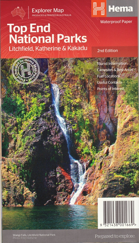
Hema Top End National Parks Map – 2nd Edition
$14.95 $15.95
Afterpay is only available for orders between $50.00 and $1000.00 More info
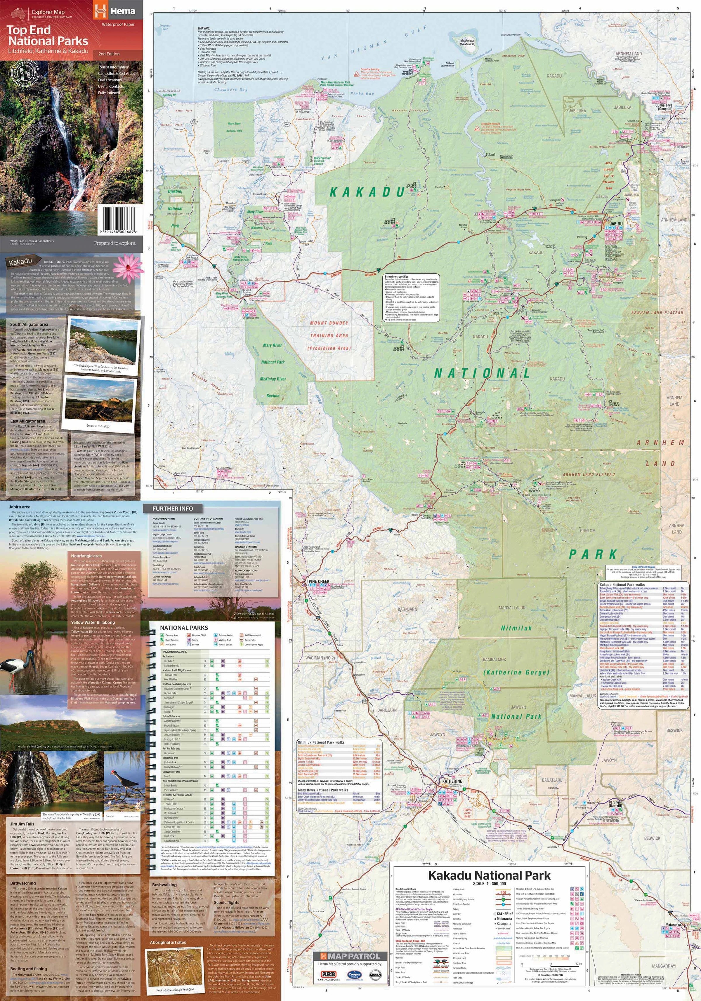
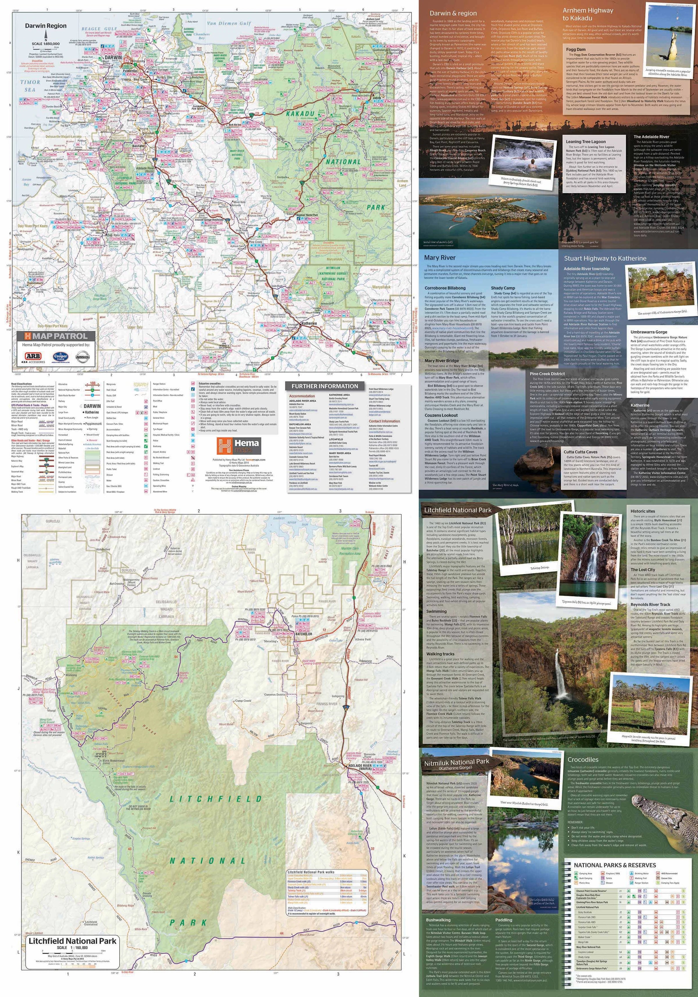
Explore the wild beauty of Australia’s Top End with a detailed guide to Kakadu, Litchfield, and Nitmiluk (Katherine Gorge) National Parks.
The Top End National Parks Map by Hema is a purpose-designed, double-sided map that gives travellers, campers, and adventurers a highly detailed and accurate representation of the Northern Territory’s most iconic natural areas. This durable and easy-to-read map is an essential companion for anyone exploring Kakadu National Park, Litchfield National Park, and Nitmiluk (Katherine Gorge) National Park.
With information tailored to self-guided touring, camping, and 4WD travel, this map provides practical details and essential visitor information while showcasing the breathtaking geography, cultural heritage, and recreational opportunities of this remarkable region.
🗺️ Regional Coverage & Scales
Each park is mapped at a scale appropriate to its size and travel complexity, providing both clarity and usable detail:
-
Litchfield National Park – Scale: 1:160,000
-
Kakadu & Nitmiluk National Parks (Katherine Gorge) – Scale: 1:350,000
-
Darwin & Surrounding Areas – Scale: 1:850,000
Together, these maps form a complete overview of the Top End’s most visited destinations, with easy-to-follow road and track networks, natural features, and park facilities clearly marked.
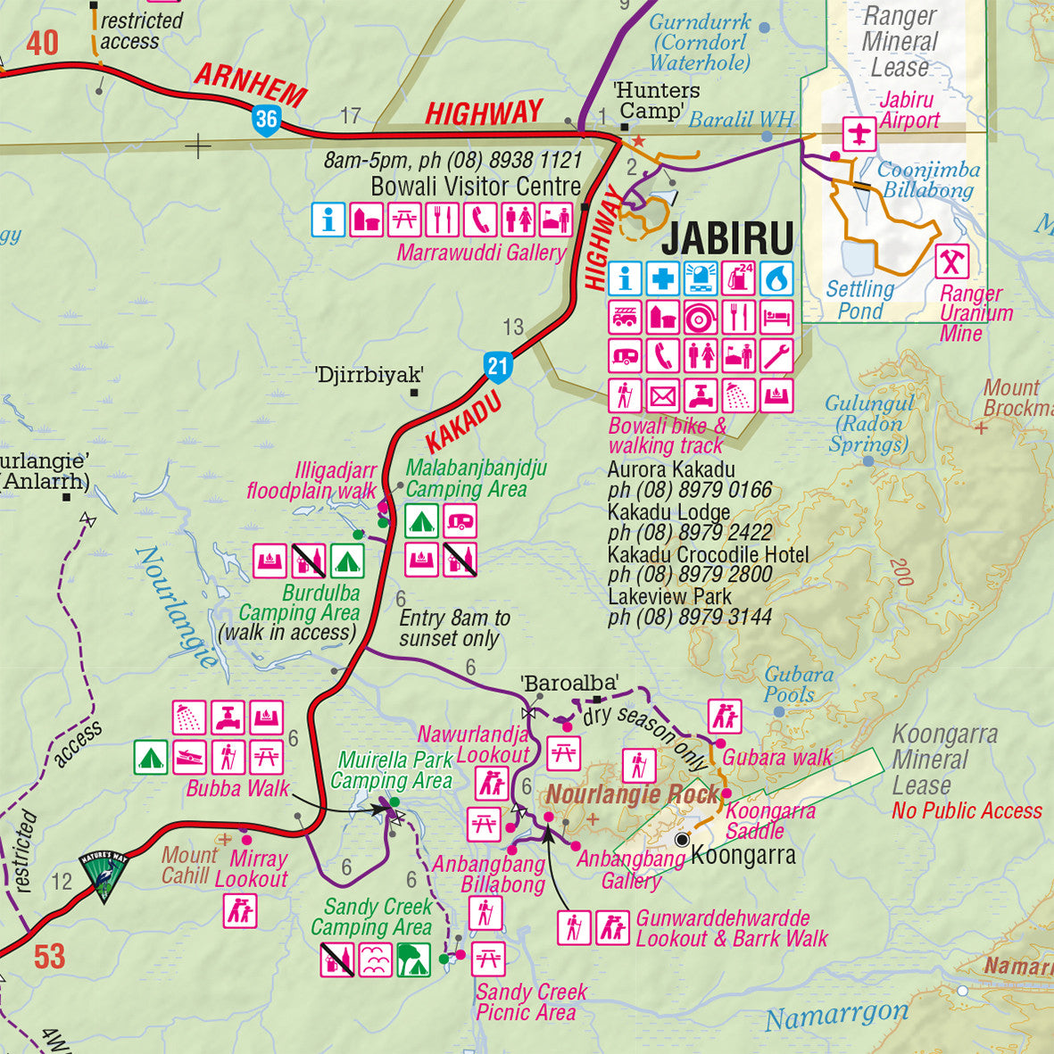
🧭 Map Features
This edition includes a host of valuable travel and navigation features:
-
All major and secondary roads, as well as unsealed roads and 4WD tracks
-
Tourist drive highlights and scenic loops through park regions
-
Clear park boundaries and entry points
-
Aboriginal land areas and permit requirements (where applicable)
-
Campsites, bush camps, rest areas, fuel stops, and visitor centres
-
Walking tracks, waterfalls, plunge pools, and major lookouts
-
Cultural and historical points of interest
-
Topographic relief shading to represent elevation and terrain
Special attention has been given to ensuring track classifications and road surfaces are clearly identified—helping you choose the best route for your vehicle and experience level.
📚 Additional Tourist Information
The reverse side includes helpful text-based guides and reference panels, covering:
-
Park regulations, fees, and contacts
-
Best time to visit and seasonal access notes (wet/dry season impacts)
-
Wildlife and vegetation to look out for
-
Cultural insights into the Indigenous heritage of the region, including traditional land ownership and sacred sites
-
Overview of the Arnhem Highway, Stuart Highway, and access routes from Darwin to Kakadu and Katherine
This makes the map not only a navigation tool but also a mini-guidebook in its own right.
📐 Map Specifications
-
Edition: 2nd
-
Published: 2014
-
Publisher: Hema Maps
-
Folded Size: 140 mm x 250 mm
-
Unfolded Size: 700 mm x 1000 mm
-
Material: Durable waterproof synthetic paper
-
Weight: Approx. 90g
-
Map Style: Double-sided, full-colour print
🎯 Perfect For
-
4WD travellers tackling tracks in Kakadu or remote regions of Litchfield
-
Campers and caravanners mapping out multi-night stays or rest stops
-
Road trippers planning scenic drives through the tropical north
-
Backpackers and hikers exploring walking trails and plunge pools
-
Educators and eco-tourists seeking to understand NT’s biodiversity and heritage
-
Photographers and cultural travellers wanting to capture both natural beauty and Indigenous connection to Country
🧭 Why Choose the Hema Top End National Parks Map?
-
Field-tested and GPS-verified by Hema’s Map Patrol
-
Updated regularly for tourist accuracy and route relevance
-
Provides more detail than general road maps or tourist brochures
-
Lightweight, waterproof, and tear-resistant – built for the Top End’s challenging conditions
-
Created by Australia’s most trusted cartographers for off-road and adventure mapping
🌿 Discover Australia’s Wild North
Whether you're standing atop Ubirr gazing across the Nadab floodplains at sunset, swimming in the clear waters of Florence Falls, or paddling beneath the sandstone cliffs of Nitmiluk Gorge, the Hema Top End National Parks Map ensures you know exactly where you are—and how to get where you're going.
Explore with confidence. Camp with clarity. Travel with purpose.
The Top End awaits. Take the map that takes you further.


