- Australia ▾
- Topographic
▾
- Australia AUSTopo 250k (2025)
- Australia 50k Geoscience maps
- Australia 100k Geoscience maps
- Australia 250k Geoscience maps
- Australia 1:1m Geoscience maps
- New Zealand 50k maps
- New Zealand 250k maps
- New South Wales 25k maps
- New South Wales 50k maps
- New South Wales 100k maps
- Queensland 10k maps
- Queensland 25k maps
- Queensland 50k maps
- Queensland 100k maps
- Western Australia 25k maps
- Western Australia 50k maps
- Western Australia 100k maps
- Compasses
- Software
- GPS Systems
- International ▾
- Wall Maps
▾
- World
- Australian Wall Maps
- Countries, Continents & Regions
- Historical
- Vintage National Geographic
- Australian Capital Territory
- New South Wales
- Northern Territory
- Queensland
- South Australia
- Tasmania
- Victoria
- Western Australia
- Celestial
- Children's
- Mining & Resources
- Wine Maps
- Healthcare
- Postcode Maps
- Electoral Maps
- Nautical ▾
- Flags
▾
- Australian Flag Sets & Banners
- Flag Bunting
- Handwavers
- Australian National Flags
- Aboriginal Flags
- Torres Strait Islander Flags
- International Flags
- Flagpoles & Accessories
- Australian Capital Territory Flags
- New South Wales Flags
- Northern Territory Flags
- Queensland Flags
- South Australia Flags
- Tasmania Flags
- Victoria Flags
- Western Australia Flags
- Gifts ▾
- Globes ▾
Dear valued customer. Please note that our checkout is not supported by old browsers. Please use a recent browser to access all checkout capabilities



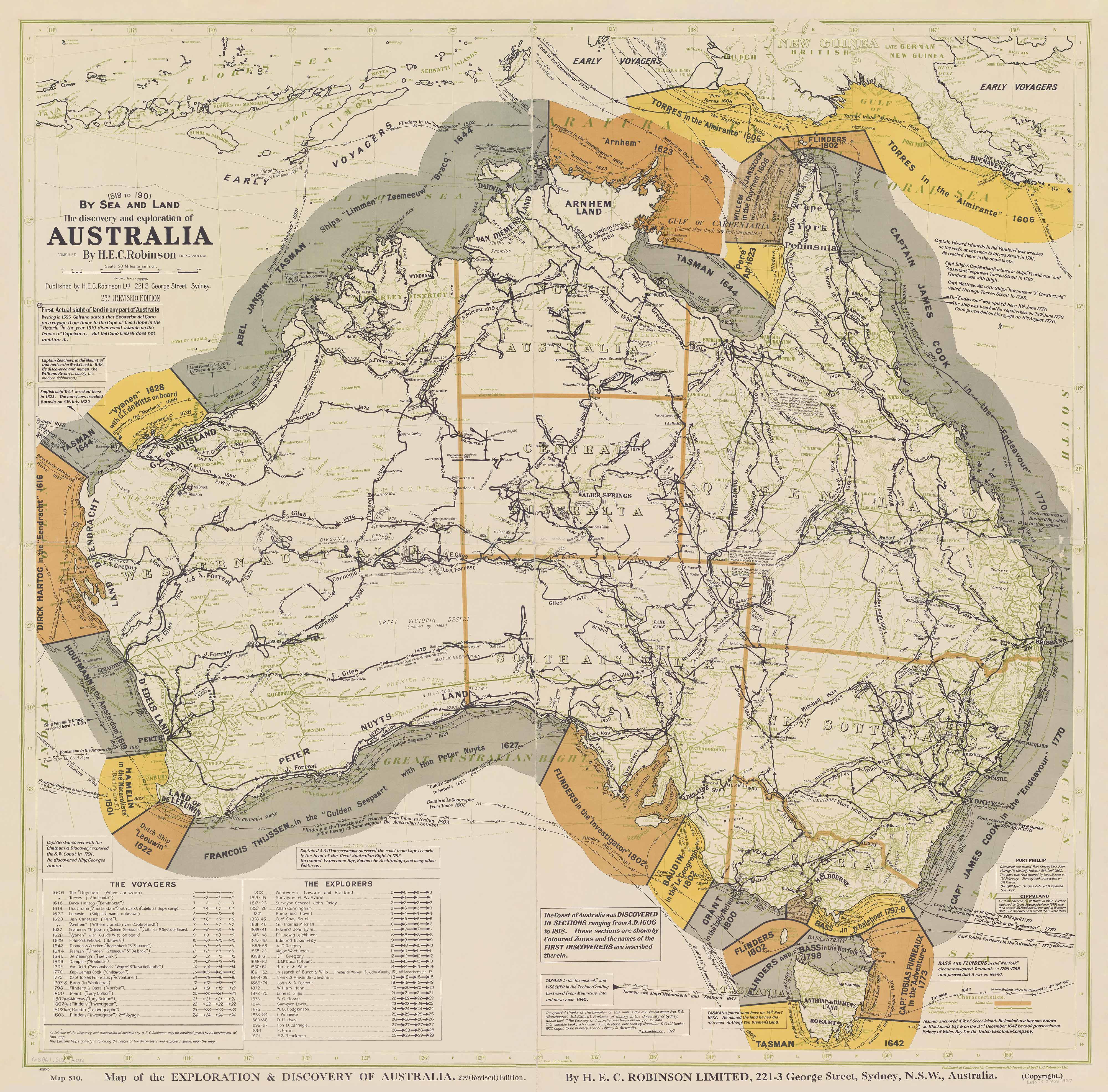


The Discovery and Exploration of Australia, 1519 to 1901 by Sea and Land Wall Map
$79.95
or make 4 interest-free payments of
$19.99 AUD
fortnightly with
 More info
The Discovery and Exploration of Australia, 1519–1901 — By Sea and Land Wall Map
Historic Exploration Routes | Beautiful Period Cartography | Australian-Printed | Two Sizes | Five Premium Finishes
Follow the voyages around Australia’s coastline—and the expeditions that ventured into its interior.
The Discovery and Exploration of Australia, 1519 to 1901 by Sea and Land Wall Map turns an extraordinary chapter of cartographic history into a richly detailed wall display. Reproduced from the historic H.E.C. Robinson map, it brings maritime voyages and inland journeys together, inviting you to follow the routes, read the annotations and discover how successive expeditions contributed to European mapping of Australia.
This is a map to spend time with—and a beautiful piece to live with. Its period lettering, decorative border, finely drawn routes and richly annotated geography give it the presence of historical artwork, while the journeys themselves invite closer reading. From across a room, the composition makes an elegant focal point. Up close, it becomes a world of ship names, dates, expeditions and discoveries to explore.
Start at a familiar stretch of coastline, follow a voyage into another sea, then turn inland to trace an expedition across the continent. Each line offers another story to investigate. Printed and professionally finished in Australia, this reproduction brings the character of historic cartography into a choice of smooth matte paper, protective gloss lamination or richly textured matte canvas—each offering a different way to enjoy the same remarkable design.
🧭 A Story Told by Sea and Land
The appeal of this map lies in seeing two strands of exploration together. Coastal voyages surround a continent crossed by inland expedition routes, creating a visual connection between the work of navigators and the journeys of overland explorers.
Rather than reading about each expedition in isolation, you can follow its place within a wider geographic story. The map encourages questions: where did a journey begin, what direction did it take, and how did its route relate to those that came before or after it?
For a history enthusiast, that makes it an absorbing reference. For a classroom, it provides a starting point for investigation. For the home, it is a piece that rewards another look long after it has been hung.
⚓ Maritime Voyages Around the Continent
The map records voyages associated with Torres, Tasman, Dampier and Flinders, placing their journeys within the coastal geography they helped document. Ship names, dates and historical annotations add detail to the routes.
Follow the lines around the coastline and consider the difference between knowing a place as a name and understanding how it came to appear on a chart. The maritime detail invites closer reading without losing the impact of the overall composition.
🥾 Inland Expeditions Across Australia
The inland mapping includes expeditions associated with Sturt, Mitchell, Leichhardt, Eyre, Burke and Wills, and Giles. Their routes give the interior a different kind of detail: a network of journeys rather than a conventional road map.
It is an engaging way to connect names encountered in books or classrooms with the places involved. A route traced across the map can become the beginning of a biography, a classroom enquiry or a deeper interest in a particular region.
🗺️ More Than a Map — A Historical Perspective
An overview that invites close study
The combination of sea and land routes allows you to move between individual expeditions and the broader exploration narrative.
Period character with lasting display appeal
Historical lettering, annotations and a decorative border give the map a character quite different from a modern reference map. It suits spaces where the pleasure of reading a map matters as much as its appearance.
A reproduction to enjoy, not an original antique
This is a modern reproduction of historic cartography, allowing the original design to be displayed in a choice of practical finishes.
Read the title in its historical context
The original wording reflects a European exploration perspective. Australia was already home to Aboriginal and Torres Strait Islander peoples, with their own knowledge of Country, routes and histories. This map should be understood as a record of the exploration narrative it depicts—not as a complete account of Australia’s history.
🎨 The Beauty of Historical Cartography
Some maps are consulted and put away. This one deserves a place where it can be seen every day.
The pleasure lies in the balance between the familiar outline of Australia and the intricate journeys drawn around and across it. Fine route lines carry the eye along the coast and into the interior; historical names and annotations invite you to pause; the decorative border gives the whole composition a sense of occasion. It is visually engaging without relying on the bold blocks of colour associated with a modern political map.
Its period character lends itself naturally to book-lined studies, traditional offices, libraries and heritage-inspired interiors. In a contemporary room, that same detail creates an appealing contrast: historical cartography set against a clean wall, with space around it to appreciate the design.
The almost-square format gives the map a substantial presence in either size. Choose the Standard for a more intimate setting or the Large for a display that lets the network of routes and annotations become a stronger feature of the room.
Beautiful enough to be chosen for its appearance, detailed enough to keep drawing you back—this is history you can spend time with.
🖨️ Print Quality That Respects the Original
A historical map depends on small details. A ship name, a date beside a route or a carefully set line of text can be just as important as the coastline itself. The reproduction therefore needs to preserve the relationship between fine lettering, delicate linework and the broader colour of the design.
Our printing places emphasis on clear detail and balanced colour, giving the routes and annotations definition without allowing them to overwhelm the historic composition. The aim is not to make an old map look newly drawn, but to present its character in a fresh print that is a pleasure to examine and display.
The material also contributes to the finished appearance. Smooth matte-coated paper gives the artwork a clean, traditional presentation. Gloss encapsulation adds a protective surface and a more reflective finish. Matte canvas introduces a visible fabric texture, bringing a softer, more tactile quality to the design. Canvas editions are printed with pigment-based inks for a fade-resistant finish.
This is a modern reproduction of a historical map, not an original antique sheet. Its appeal is the opportunity to enjoy the period design in a newly produced print, with a finish selected for the way you want to use it.
📐 Two Size Options
Choose the size that suits your wall and the amount of space you would like for examining the detail.
| Size | Dimensions | Suggested setting |
|---|---|---|
| Standard | 900 mm (W) × 890 mm (H) | Studies, home offices, smaller learning spaces and personal map collections. |
| Large | 1200 mm (W) × 1180 mm (H) | Libraries, classrooms, meeting rooms and larger feature walls. |
The larger format gives the same historical artwork more room, making the route annotations easier to examine up close. Both options offer a distinctive, almost-square presentation.
✨ Premium Materials & Finishes
The finish is part of the experience. Choose the smooth clarity of paper, the practicality of lamination or the fabric texture of canvas, then decide whether you would prefer conventional framing or fitted timber hang rails.
| Format | Description |
|---|---|
| 📜 Paper — 160 gsm | Heavyweight matte-coated paper with a smooth surface that complements fine lettering and route detail. A classic choice for framing under glass. |
| 🧼 Laminated — Encapsulated | The paper map is fully sealed between two sheets of 80-micron gloss laminate—one on each side. The protective surface is durable and wipe-clean, with a gloss sheen that gives the print a different character from the matte paper edition. |
| 🪵 Laminated with Timber Hang Rails | The encapsulated map is fitted with lacquered natural timber rails at the top and bottom, plus a hanging cord. A practical, ready-to-display finish without a conventional frame. |
| 🖼️ Canvas — 395 gsm | HP Professional Matte Canvas, printed with pigment-based inks. The substantial fabric and matte texture give the historic design a warm, art-print appearance with a fade-resistant finish. |
| 🪵 Canvas with Timber Hang Rails | Textured canvas finished with lacquered natural timber rails and a hanging cord. A distinctive, frameless presentation that pairs the character of the map with the warmth of natural wood. |
📜 Heavyweight Paper — A Classic Cartographic Finish
The 160 gsm matte-coated paper is an appealing choice when you want the historical artwork itself to take the lead. Its smooth surface offers a clean setting for small place names, expedition dates and the fine lines that connect the journeys.
Without the added sheen of gloss lamination, the unframed print has a restrained, traditional appearance. It is particularly well suited to framing under glass, whether you choose a heritage-style timber frame or a simpler contemporary setting. The paper version is supplied without a frame, leaving that final presentation to you.
🧼 Gloss Lamination — Beauty with Everyday Practicality
For a map that will be consulted regularly, true encapsulation adds protection while retaining the visual interest of the original design. An 80-micron gloss sheet on the front and another on the back enclose the paper, creating a finish that is easier to keep clean and less vulnerable to handling than an unprotected print.
The gloss surface gives colours and linework a lively presentation, making this a practical choice for classrooms, shared offices, libraries and family spaces. It is the finish for buyers who want to enjoy the map as both a display piece and a frequently used reference.
🖼️ Matte Canvas — Texture, Warmth & Presence
The 395 gsm HP Professional Matte Canvas offers a different experience from smooth paper. Its fabric texture becomes part of the presentation, adding tactile interest to the historical lettering, coastline and intricate expedition routes.
Printed with pigment-based inks, the canvas combines a fade-resistant finish with the softer appearance of a matte surface. It is especially appealing when the map is intended as a decorative centrepiece: something to admire as a whole, then approach to discover the stories within it.
Canvas is a compelling choice for studies, living rooms, libraries and reception spaces, where the atmosphere of the artwork matters alongside its reference value. The canvas-only option is supplied without timber rails or a conventional frame; choose the hang-railed version for a finished hanging presentation.
🪵 Natural Timber Hang Rails — An Elegant Finishing Touch
The optional natural timber rails frame the top and bottom of the map without enclosing it behind glazing. Their lacquered finish brings out the character of the wood and sits comfortably alongside the map’s historical styling.
Fitted by our framer, the rails provide a neat, balanced presentation with a hanging cord attached to the upper rail. The result is ready to hang from a suitable wall fixing—no conventional picture frame required.
On laminated maps, the rails create a practical reference display. On canvas, the combination of matte fabric and natural timber gives the artwork a particularly warm, understated presence.
Please allow 10 working days for hang-railed maps, as each is professionally mounted by our framer.
📊 Map Specifications
| Feature | Detail |
|---|---|
| Title | The Discovery and Exploration of Australia, 1519 to 1901 by Sea and Land |
| Original compiler / publisher | H.E.C. Robinson Ltd., Sydney |
| Original publication year | 1927 |
| Historical coverage | 1519–1901, as stated in the original title |
| Map type | Historical exploration map / reproduction |
| Subject | Maritime voyages and inland expeditions |
| Standard size | 900 mm (W) × 890 mm (H) |
| Large size | 1200 mm (W) × 1180 mm (H) |
| Paper stock | 160 gsm matte-coated paper |
| Lamination | 2 × 80-micron gloss encapsulation |
| Canvas | 395 gsm HP Professional Matte Canvas |
| Finish options | Paper, Laminated, Laminated with Timber Hang Rails, Canvas, Canvas with Timber Hang Rails |
| Production | Printed and professionally finished in Australia |
🎁 Perfect for History Lovers, Educators & Collectors
For homes and studies, this map offers more than a decorative background. It gives visitors something to notice and its owner something to return to—a route, a name or a historical detail that had previously escaped attention.
For classrooms and libraries, it can support activities comparing voyages, following expedition routes and discussing how historical maps reflect the perspectives of their makers.
For collectors and gift-givers, it offers a distinctive connection between Australian history and the visual appeal of period cartography. It is a thoughtful choice for someone who enjoys maritime history, inland exploration or the stories behind familiar place names.
🤝 Our Commitment
Local craftsmanship: Printed and professionally finished in Australia, with attention to the small details that make historic cartography so rewarding to own.
Materials with purpose: From smooth 160 gsm matte-coated paper and protective 2 × 80-micron gloss encapsulation to 395 gsm HP Professional Matte Canvas, each option offers a distinct balance of appearance, texture and practicality.
Colour-managed clarity: Care taken over the relationship between the artwork’s colours, fine route lines, historical lettering and annotations, so the finished print feels coherent rather than overworked.
Professional finishing: Natural timber hang rails fitted by our framer, with a lacquered finish and hanging cord for a considered, ready-to-display result.
Packed with care: Each map is checked before dispatch and packaged for its size and finish, with fitted timber rails protected during transport.
🚚 Delivery & Finishing
Paper, laminated and canvas maps are carefully prepared and packaged for transport.
Hang-railed maps are professionally mounted to order. Please allow 10 working days for this finish.
Fitted timber rails are protected during packing so your map arrives ready for display.
🌏 Let the Journeys Continue on Your Wall
There is a particular pleasure in following a journey with your fingertip: leaving a coastline, rounding a cape, crossing an inland expanse and imagining the questions that lay ahead.
The Discovery and Exploration of Australia, 1519 to 1901 by Sea and Land brings that experience into your everyday surroundings. Its intricate routes, period lettering and decorative character offer the pleasure of historical artwork, while its stories reward the curiosity of a reader.
Imagine it above a desk, beside a favourite reading chair or on the wall of a room where journeys are discussed and books are always close at hand. Choose smooth paper for a beautifully framed presentation, lamination for a map you will consult often, or matte canvas with natural timber rails for an especially warm and characterful display.
Whether it becomes a gift for a history enthusiast, a classroom resource or the centrepiece of your own study, this is a print to enjoy both for what it reveals and for the way it makes a room feel.
Choose your size and finish, and give Australia’s maritime and inland exploration story a place on your wall.
Frequently Asked Questions
What does The Discovery and Exploration of Australia wall map show?
The map brings together maritime voyages around Australia and inland expedition routes for the period 1519 to 1901, as stated in its original title. Ship names, dates and historical annotations accompany the routes, while period lettering and a decorative border give the map its historical character.
Is this an original antique map or a reproduction?
This is a modern reproduction of the historical map originally published by H.E.C. Robinson Ltd., Sydney, in 1927. It is not an original antique sheet. The dates 1519 to 1901 describe the historical period covered by the map, not when this print was produced.
Which explorers are featured on the map?
The map includes maritime voyages associated with Torres, Tasman, Dampier and Flinders, together with inland expeditions associated with Sturt, Mitchell, Leichhardt, Eyre, Burke and Wills, and Giles.
What sizes are available?
Two sizes are available: Standard, 900 mm wide x 890 mm high; and Large, 1200 mm wide x 1180 mm high. Both have an almost-square format. The Large version gives the same historical artwork more space, making route annotations easier to examine up close.
What finishes are available?
Choose from Paper, Laminated, Laminated with Timber Hang Rails, Canvas, or Canvas with Timber Hang Rails. Paper offers a smooth, traditional presentation, lamination adds a protective gloss surface, and canvas provides a textured matte finish.
What paper is used for the paper version?
The paper version is printed on heavyweight 160 gsm matte-coated paper. Its smooth surface complements the fine lettering, expedition dates and route lines. It is supplied without a frame and is suitable for framing under glass.
How is the laminated map finished?
The paper map is fully encapsulated between two sheets of 80-micron gloss laminate, with one sheet on the front and one on the back. This creates a durable, wipe-clean surface that protects the print during regular handling and gives it a gloss finish.
What canvas and inks are used?
Canvas editions are printed on 395 gsm HP Professional Matte Canvas using pigment-based inks for a fade-resistant finish. The fabric texture and matte surface give the historical artwork a warm, art-print appearance. The canvas-only option is supplied without timber rails or a conventional frame.
Do the timber hang-railed versions arrive ready to hang?
Yes. Laminated and canvas hang-railed versions are professionally fitted with lacquered natural timber rails at the top and bottom, with a hanging cord attached to the upper rail. They can be displayed from a suitable wall fixing without a conventional picture frame.
How long do hang-railed maps take?
Please allow 10 working days for hang-railed maps, as each is professionally mounted to order by our framer.
Where is the map printed and finished?
This reproduction is printed and professionally finished in Australia. Each map is checked before dispatch and packaged for its size and chosen finish, with fitted timber rails protected during transport.
How should the historical title be understood?
The title reflects the European exploration perspective of the original map. Australia was already home to Aboriginal and Torres Strait Islander peoples, with their own knowledge of Country, routes and histories. This map records the exploration narrative it depicts rather than providing a complete account of Australian history.
Related Items
© 2026 Mapworld. Website designed by Genie Media


X