- Australia ▾
- Topographic
▾
- Australia AUSTopo 250k (2025)
- Australia 50k Geoscience maps
- Australia 100k Geoscience maps
- Australia 250k Geoscience maps
- Australia 1:1m Geoscience maps
- New Zealand 50k maps
- New Zealand 250k maps
- New South Wales 25k maps
- New South Wales 50k maps
- New South Wales 100k maps
- Queensland 10k maps
- Queensland 25k maps
- Queensland 50k maps
- Queensland 100k maps
- Compasses
- Software
- GPS Systems
- Orienteering
- International ▾
- Wall Maps
▾
- World
- Australia & New Zealand
- Countries, Continents & Regions
- Historical
- Vintage National Geographic
- Australian Capital Territory
- New South Wales
- Northern Territory
- Queensland
- South Australia
- Tasmania
- Victoria
- Western Australia
- Celestial
- Children's
- Mining & Resources
- Wine Maps
- Healthcare
- Postcode Maps
- Electoral Maps
- Nautical ▾
- Flags
▾
- Australian Flag Sets & Banners
- Flag Bunting
- Handwavers
- Australian National Flags
- Aboriginal Flags
- Torres Strait Islander Flags
- International Flags
- Flagpoles & Accessories
- Australian Capital Territory Flags
- New South Wales Flags
- Northern Territory Flags
- Queensland Flags
- South Australia Flags
- Tasmania Flags
- Victoria Flags
- Western Australia Flags
- Gifts ▾
- Globes ▾
Dear valued customer. Please note that our checkout is not supported by old browsers. Please use a recent browser to access all checkout capabilities


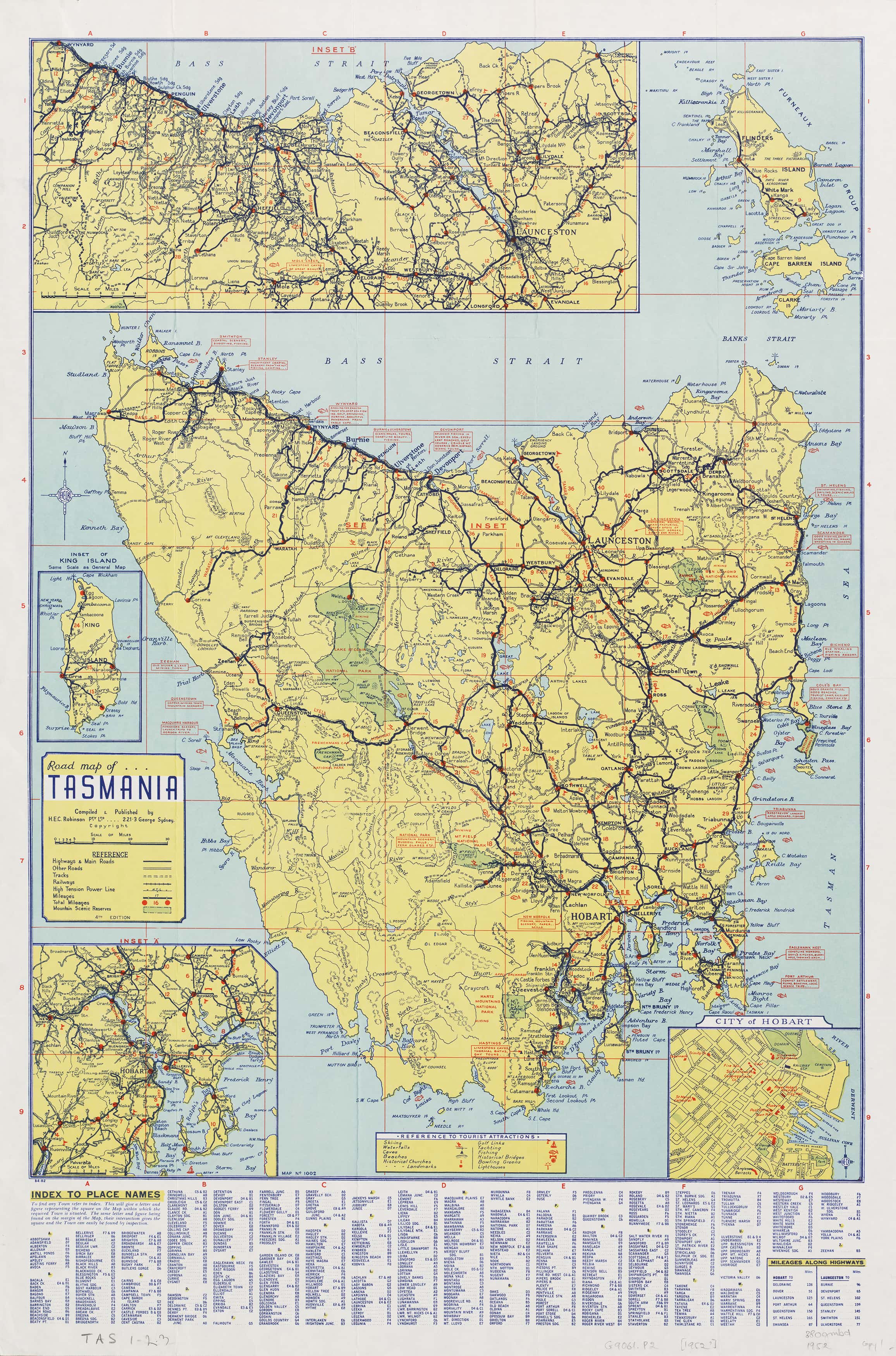
Tasmania Road Wall Map by Robinson published 1952
$69.95
or make 4 interest-free payments of
$17.49 AUD
fortnightly with
![]() More info
More info
Tasmania 1952 Road Map by H.E.C. Robinson – A Journey Through Time
Step back into post-war Australia with this exquisitely restored 1952 Road Map of Tasmania—a masterpiece by the legendary H.E.C. Robinson, widely regarded as Australia’s master cartographer. Known for his elegance, precision, and artistic clarity, Robinson’s work transforms maps into enduring works of visual storytelling.
This vintage map captures a pivotal moment in Tasmania’s modern history, just as the island was emerging from the shadows of war and embracing a new era of development and tourism. Roads were expanding, rail lines still pulsed with passenger trains, and the “Apple Isle” was beginning to reveal its wild beauty to the mainland and the world.
Lovingly brought back to life through high-resolution restoration and printed on premium materials, this map is both a decorative centrepiece and a window into the soul of 1950s Tasmania.
🍏 A Vintage Portrait of Tasmania, the Apple Isle
Robinson’s detailed portrayal includes:
-
Highways and arterial roads as they existed in the early 1950s
-
Railway lines and branches, including many that no longer exist today
-
Ferry routes, connecting key towns across Bass Strait and surrounding waters
-
National parks, scenic reserves, rivers, and mountain ranges lovingly illustrated
-
A charming network of townships and country roads, evoking the era of post-war motoring adventures
This was Tasmania before mass tourism, before the rise of the airport, before highways replaced heritage lines—making this map a time capsule of infrastructure, geography, and aspiration.
🔍 Historic Inset Maps
To deepen the immersion, Robinson included detailed inset maps:
-
🏙️ Hobart City
-
🌄 Greater Hobart Surrounds
-
🌉 Launceston Region
-
🏝️ King Island
Each inset reveals not just geography, but character—from colonial street grids to the ferry docks that once bustled with Tasmanian life.
🎨 Presentation & Finish Options
Crafted with care, this reproduction is available in a variety of premium finishes to suit your space and style:
| Finish Type | Description |
|---|---|
| Paper (160 gsm) | A smooth, archival-grade finish ideal for framing under glass—preserves vintage authenticity. |
| Laminated | True 80-micron gloss encapsulation allows use with whiteboard markers or map dots. A durable, markable surface perfect for homes, schools, and offices. |
| Canvas (395 gsm) | Printed on museum-quality HP Matte Canvas using pigment-based inks for rich colour, texture, and long-lasting durability. Fade-resistant and elegant. |
🪵 Optional Wooden Hang Rails
Both Laminated and Canvas versions can be fitted with beautiful natural timber hang rails and a hanging cord, creating a ready-to-display piece that requires no frame. This gallery-style finish is ideal for:
-
Renters
-
Home studies
-
Libraries and history rooms
-
Antique-style décor
🛠️ Please allow up to 10 working days for hang-railed versions, as each one is custom-fitted by our professional framer in Sydney.
📐 Specifications
-
Cartographer: H.E.C. Robinson
-
Year of Original Publication: 1952
-
Map Dimensions: 1000 mm (H) × 660 mm (W)
-
Publisher: H.E.C. Robinson Pty Ltd, Sydney
-
Reproduction: Digitally restored using high-resolution scans
-
Made in: Australia
💫 A Piece of History for Every Tasmanian Soul
Whether you’re:
-
Commemorating a Tasmanian heritage journey
-
Gifting a nostalgic piece of Australiana
-
Decorating a home with vintage character
-
Teaching students about post-war development
-
Or simply longing for a visual connection to Tasmania’s storied past…
This map is more than lines and legends—it’s a reminder of who we were, and a celebration of the landscapes that still inspire.
Bring Tasmania’s golden era into your space.
Let your walls whisper stories of winding roads, railways to nowhere, and a land coming into its own.
