- Australia ▾
- Topographic
▾
- Australia AUSTopo 250k (2025)
- Australia 50k Geoscience maps
- Australia 100k Geoscience maps
- Australia 250k Geoscience maps
- Australia 1:1m Geoscience maps
- New Zealand 50k maps
- New Zealand 250k maps
- New South Wales 25k maps
- New South Wales 50k maps
- New South Wales 100k maps
- Queensland 10k maps
- Queensland 25k maps
- Queensland 50k maps
- Queensland 100k maps
- Western Australia 25k maps
- Western Australia 50k maps
- Western Australia 100k maps
- Compasses
- Software
- GPS Systems
- International ▾
- Wall Maps
▾
- World
- Australia & New Zealand
- Countries, Continents & Regions
- Historical
- Vintage National Geographic
- Australian Capital Territory
- New South Wales
- Northern Territory
- Queensland
- South Australia
- Tasmania
- Victoria
- Western Australia
- Celestial
- Children's
- Mining & Resources
- Wine Maps
- Healthcare
- Postcode Maps
- Electoral Maps
- Nautical ▾
- Flags
▾
- Australian Flag Sets & Banners
- Flag Bunting
- Handwavers
- Australian National Flags
- Aboriginal Flags
- Torres Strait Islander Flags
- International Flags
- Flagpoles & Accessories
- Australian Capital Territory Flags
- New South Wales Flags
- Northern Territory Flags
- Queensland Flags
- South Australia Flags
- Tasmania Flags
- Victoria Flags
- Western Australia Flags
- Gifts ▾
- Globes ▾
Dear valued customer. Please note that our checkout is not supported by old browsers. Please use a recent browser to access all checkout capabilities


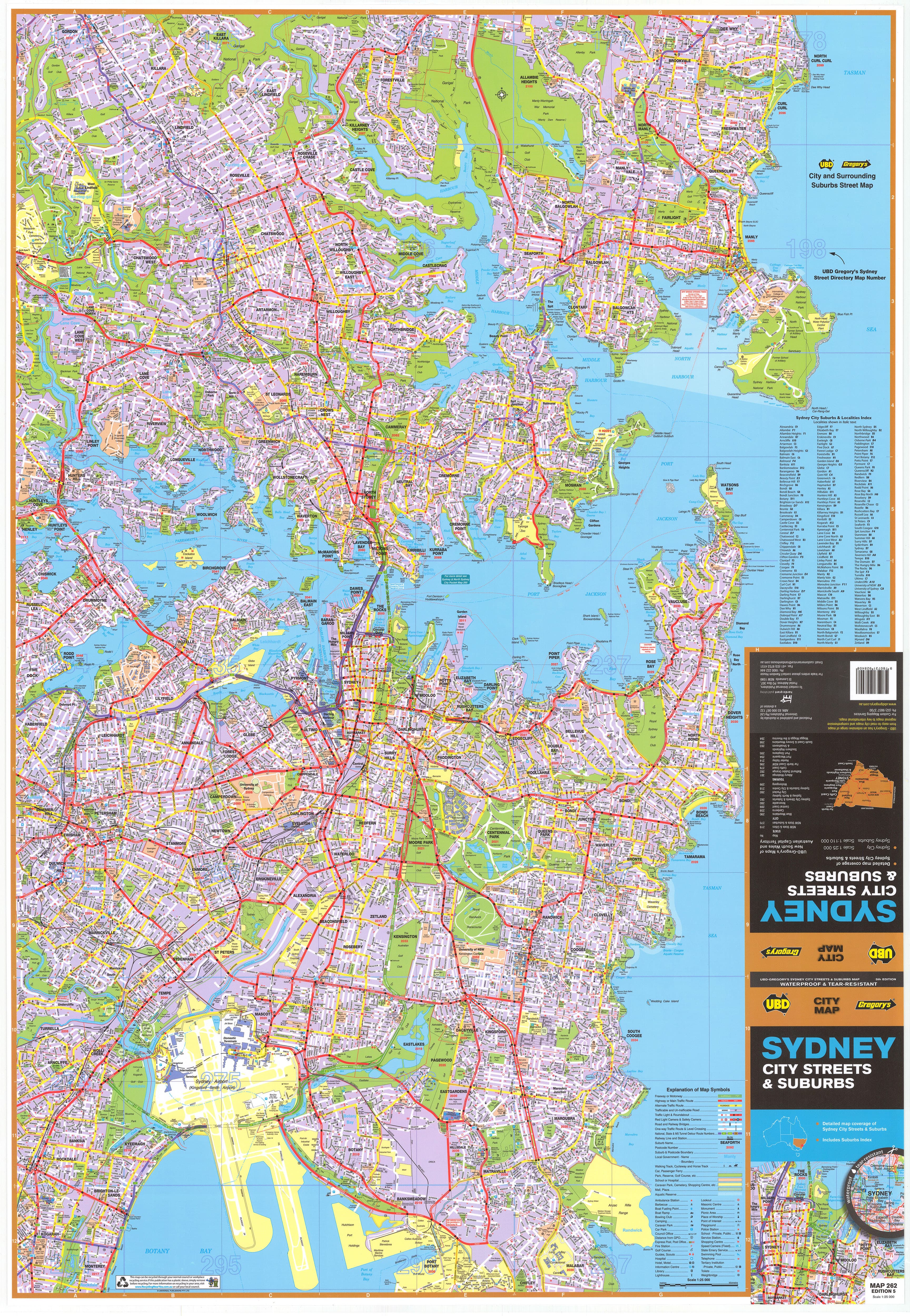
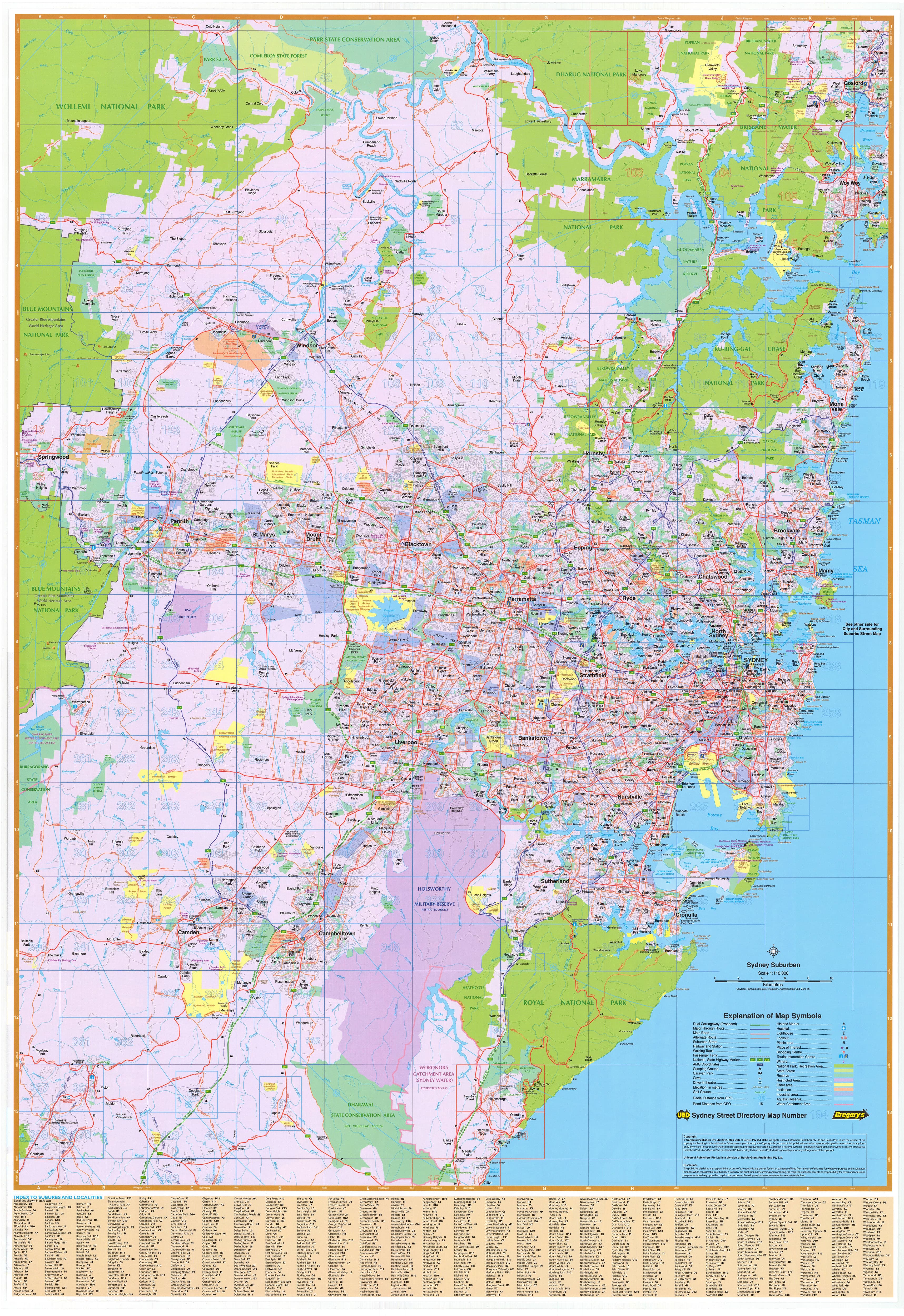
Sydney City Streets & Suburbs Map UBD 262
$99.00
or make 4 interest-free payments of
$24.75 AUD
fortnightly with
![]() More info
More info
The most detailed and practical Sydney wall map available — perfect for the home, office, classroom, or anywhere clarity and precision matter
This double-sided map of Sydney, published by UBD Gregory’s, is a comprehensive, high-quality resource offering both street-level detail of central Sydney suburbs and a wide-angle view of the Greater Sydney metropolitan area. Whether you’re navigating the city, managing a delivery route, searching for a new home, or planning business growth, this map provides the scale, legibility, and functionality needed to see the city from every angle.
Carefully researched and professionally presented, it is ideal for professionals, educators, real estate agents, business owners, and everyday Sydneysiders wanting a clearer understanding of one of the world’s most complex and expansive urban environments.
🗺️ Dual-Sided Coverage for Total Perspective
🧭 Side One – Central Sydney in Fine Detail (Scale 1:25,000)
This side of the map focuses on the central, inner-city, and eastern suburbs of Sydney with street-level accuracy, covering an area from:
-
Gordon in the north-west
-
Across to North Curl Curl in the north-east
-
Down to Monterey in the south-west
-
Extending east to Malabar in the south-east
You’ll find:
-
Every road, street, and lane labelled
-
Clear depiction of parks, reserves, rivers, train stations, landmarks, and built infrastructure
-
Precise boundaries between suburbs and localities
-
Ideal for service area planning, navigation, real estate, and local government use
This detailed inner-zone view is perfect for industries that operate in high-density urban areas, such as transport, healthcare, field services, and urban development.
🌆 Side Two – Greater Sydney & Surrounds (Scale 1:110,000)
Zooming out, the reverse side provides a broader view of Greater Sydney, extending from:
-
Gosford on the Central Coast
-
Down to Clifton, south of the Royal National Park
-
West to Springwood in the lower Blue Mountains
It includes:
-
Main arterial roads, tollways, and ring routes clearly marked
-
Differentiated zones showing suburban, industrial, and natural park areas
-
All Sydney suburbs listed with postcode references, with a full suburb index included
-
Major infrastructure like airports, hospitals, and universities identified
This side is ideal for regional route planning, service coverage, suburban expansion tracking, or simply gaining a broad yet legible overview of the city.
📐 Map Specifications:
-
Size: 700 mm (width) x 1000 mm (height) — a manageable format for most wall spaces
-
Scales:
-
Central Suburbs: 1:25,000
-
Greater Sydney: 1:110,000
-
-
Edition: Published 2022
-
Publisher: UBD Gregory’s – Australia's most trusted name in street mapping
-
Map Style: Clear, colour-coded, easy to read, with high-contrast labels and borders
🧽 Lamination Options:
✅ Flat Laminated Map – $99.00
-
Professionally laminated and shipped flat
-
Ideal for display, pinboards, or custom framing
-
Encapsulated in high-gloss 80-micron laminate, offering a durable, wipeable surface
-
Compatible with whiteboard markers and map dots for interactive use
-
Best suited to offices, classrooms, real estate agencies, planners, or map enthusiasts
✅ Laminated Folded Map – $49.95
-
A budget-friendly option, made by laminating a previously folded map
-
Slight crease lines may be visible but does not affect usability
-
Fully protected by gloss lamination and usable with whiteboard markers
-
Great for more casual use or as a functional wall tool
🎯 Perfect For:
-
House Hunters & Renters – Visualise prospective neighbourhoods, proximity to CBD, parks, and schools
-
Real Estate Professionals – Plan sales areas, rental portfolios, or marketing territories
-
Business Owners – Optimise delivery zones, service calls, or franchise areas
-
Teachers & Students – A valuable learning resource for geography, urban studies, and planning
-
Planners & Developers – Understand zoning, growth corridors, and infrastructure distribution
-
Design-Conscious Decorators – A functional and attractive wall feature for modern spaces
🧭 Why Choose This Map?
-
Clear dual-scale design for both fine and wide-scale Sydney views
-
Expert cartography from UBD Gregory’s, with decades of mapping experience
-
Covers every suburb, with postcode identification and index
-
Visually appealing and easy to read, even from a distance
-
Made to last, with high-quality lamination to suit active use or display
Whether you're tracking postcodes, mapping service routes, or just appreciating the scale and diversity of Sydney, this map delivers insight, precision, and polish in equal measure.
See your city. Understand the layout. Plan with confidence — with UBD Gregory’s Sydney City Streets & Suburbs Map.
Frequently Asked Questions
Where can I buy the Sydney City Streets & Suburbs Map UBD 262?
The Sydney City Streets & Suburbs Map UBD 262 is available to buy online from Mapworld, Australia's largest map and geographic product retailer, with fast shipping Australia-wide.
Is the Sydney City Streets & Suburbs Map UBD 262 in stock at Mapworld?
Mapworld maintains extensive stock across its map range and aims for fast dispatch. Orders placed before 2pm AEST on business days are typically dispatched the same day, with standard and express Australia-wide delivery options available.
What is Mapworld's returns policy?
Mapworld accepts returns on undamaged items in original condition. Contact Mapworld within 90 days of purchase to arrange a return or exchange.
Does Mapworld ship the Sydney City Streets & Suburbs Map UBD 262 across Australia?
Yes, Mapworld ships Australia-wide. Standard shipping is a flat $7 rate, with free standard shipping on orders over $75. Express options are available at checkout. Most orders placed before 2pm AEST on weekdays are dispatched same day.
Related Items


© 2026 Mapworld. Website designed by Genie Media
X