- Australia ▾
- Topographic
▾
- Australia AUSTopo 250k (2024)
- Australia 50k Geoscience maps
- Australia 100k Geoscience maps
- Australia 250k Geoscience maps
- Australia 1.1m Geoscience maps
- New Zealand 50k maps
- New Zealand 250k maps
- New South Wales 25k maps
- New South Wales 50k maps
- New South Wales 100k maps
- Queensland 10k maps
- Queensland 25k maps
- Queensland 50k maps
- Queensland 100k maps
- Compasses
- Software
- GPS Systems
- Orienteering
- International ▾
- Wall Maps
▾
- World
- Australia & New Zealand
- Countries, Continents & Regions
- Historical
- Vintage National Geographic
- Australian Capital Territory
- New South Wales
- Northern Territory
- Queensland
- South Australia
- Tasmania
- Victoria
- Western Australia
- Celestial
- Children's
- Mining & Resources
- Wine Maps
- Healthcare
- Postcode Maps
- Electoral Maps
- Nautical ▾
- Flags
▾
- Australian Flag Sets & Banners
- Flag Bunting
- Handwavers
- Australian National Flags
- Aboriginal Flags
- Torres Strait Islander Flags
- International Flags
- Flagpoles & Accessories
- Australian Capital Territory Flags
- New South Wales Flags
- Northern Territory Flags
- Queensland Flags
- South Australia Flags
- Tasmania Flags
- Victoria Flags
- Western Australia Flags
- Gifts ▾
- Globes ▾
Dear valued customer. Please note that our checkout is not supported by old browsers. Please use a recent browser to access all checkout capabilities


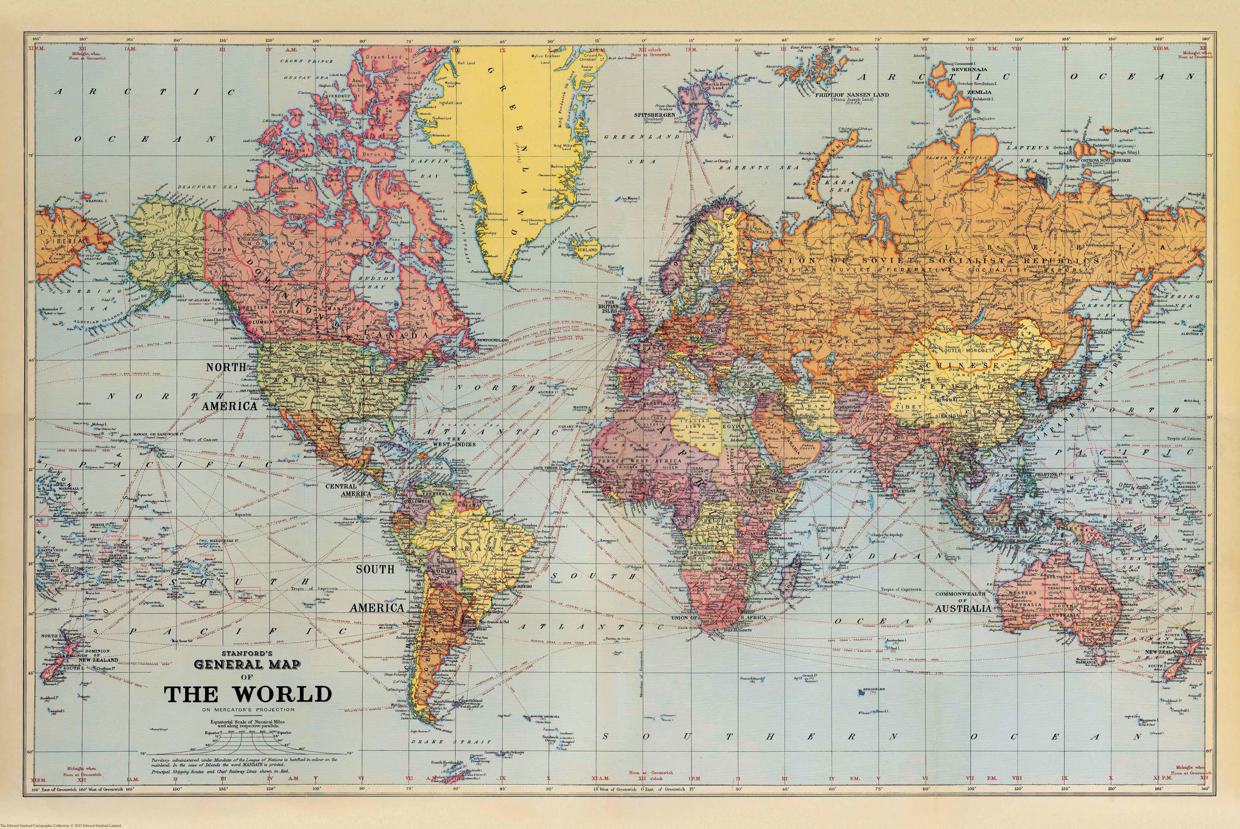
Stanford's General Map of the World (1920)
$69.95
or make 4 interest-free payments of
$17.49 AUD
fortnightly with
![]() More info
More info
A Post-War Vision of the Globe in Mercator Projection
Size: 474 mm (w) x 709 mm (h)
Published: 1920 | Edward Stanford Cartographic Collection
This exceptional historical reproduction—Stanford’s General Map of the World (1920)—captures a defining moment in geopolitical history. Published in the wake of the First World War, the map reflects the redrawn boundaries and political restructuring that followed the Treaty of Versailles, offering a fascinating glimpse into the world as it stood on the edge of a new era.
🌍 Historical Significance
Stanford’s map stands out not only for its cartographic clarity but also for what it reveals about the early 20th century’s world order. Territories are shown in strikingly differentiated colours, highlighting:
-
British Dominions rendered in red, denoting the vast reach of the British Empire at its zenith
-
French and Belgian colonies, and
-
Territories newly assigned under the Mandate system of the League of Nations, marking the transition from imperial conquest to international administration
The map notes these colonial possessions and mandates explicitly, offering historians and collectors a powerful artefact from the interwar period.
🗺️ Cartographic Features
-
Projection: Mercator’s Projection—ideal for maritime navigation and traditional global views
-
Latitude and Longitude: Clearly delineated at 15-degree intervals, with longitude lines annotated to show the time difference from the Greenwich Meridian
-
Topographic Detail: Major mountain ranges, rivers, and extensive place names across every continent
-
Transport Infrastructure: Principal railway routes on land and global shipping routes at sea, complete with distances
This map is not just an object of beauty—it’s an informative reference work as relevant today to scholars and collectors as it was to navigators and diplomats a century ago.
🖨️ Print & Material Options
You may choose from the following premium finishes:
| Finish | Details |
|---|---|
| Paper | Printed on heavyweight 160 gsm archival-quality paper—perfect for framing under glass |
| Laminated | Encapsulated in 80-micron gloss laminate—durable, writable, and tear-resistant |
| Canvas | Printed on 395 gsm HP Professional Matte Canvas using pigment-based inks—fade-resistant, museum-quality reproduction |
🖼️ Hanging Options
For laminated and canvas versions, we offer optional wooden hang rails—lacquered in a natural timber finish—attached top and bottom, with a hanging cord included. This elegant presentation method allows you to install the map with a single wall hook, instantly transforming your space.
📦 Please allow up to 10 working days for delivery of hang-railed maps, as each is hand-finished by our professional framer.
✅ Why Choose This Map?
-
An original 1920 document reprinted from the Edward Stanford archive
-
Ideal for libraries, study walls, historical collections, and educational settings
-
A visual record of post-WWI colonial administration and global trade routes
-
A beautiful gift for historians, collectors, or map lovers with a fascination for the early 20th century world
Made in Australia | Archival-Grade Reproduction | Historical Accuracy Guaranteed
Let the world of 1920 unfold before your eyes—where Empire was still global currency, railways knit the continents together, and the League of Nations stood as a fragile hope for peace.


