- Australia ▾
- Topographic
▾
- Australia AUSTopo 250k (2025)
- Australia 50k Geoscience maps
- Australia 100k Geoscience maps
- Australia 250k Geoscience maps
- Australia 1:1m Geoscience maps
- New Zealand 50k maps
- New Zealand 250k maps
- New South Wales 25k maps
- New South Wales 50k maps
- New South Wales 100k maps
- Queensland 10k maps
- Queensland 25k maps
- Queensland 50k maps
- Queensland 100k maps
- Western Australia 25k maps
- Western Australia 50k maps
- Western Australia 100k maps
- Compasses
- Software
- GPS Systems
- International ▾
- Wall Maps
▾
- World
- Australia & New Zealand
- Countries, Continents & Regions
- Historical
- Vintage National Geographic
- Australian Capital Territory
- New South Wales
- Northern Territory
- Queensland
- South Australia
- Tasmania
- Victoria
- Western Australia
- Celestial
- Children's
- Mining & Resources
- Wine Maps
- Healthcare
- Postcode Maps
- Electoral Maps
- Nautical ▾
- Flags
▾
- Australian Flag Sets & Banners
- Flag Bunting
- Handwavers
- Australian National Flags
- Aboriginal Flags
- Torres Strait Islander Flags
- International Flags
- Flagpoles & Accessories
- Australian Capital Territory Flags
- New South Wales Flags
- Northern Territory Flags
- Queensland Flags
- South Australia Flags
- Tasmania Flags
- Victoria Flags
- Western Australia Flags
- Gifts ▾
- Globes ▾
Dear valued customer. Please note that our checkout is not supported by old browsers. Please use a recent browser to access all checkout capabilities


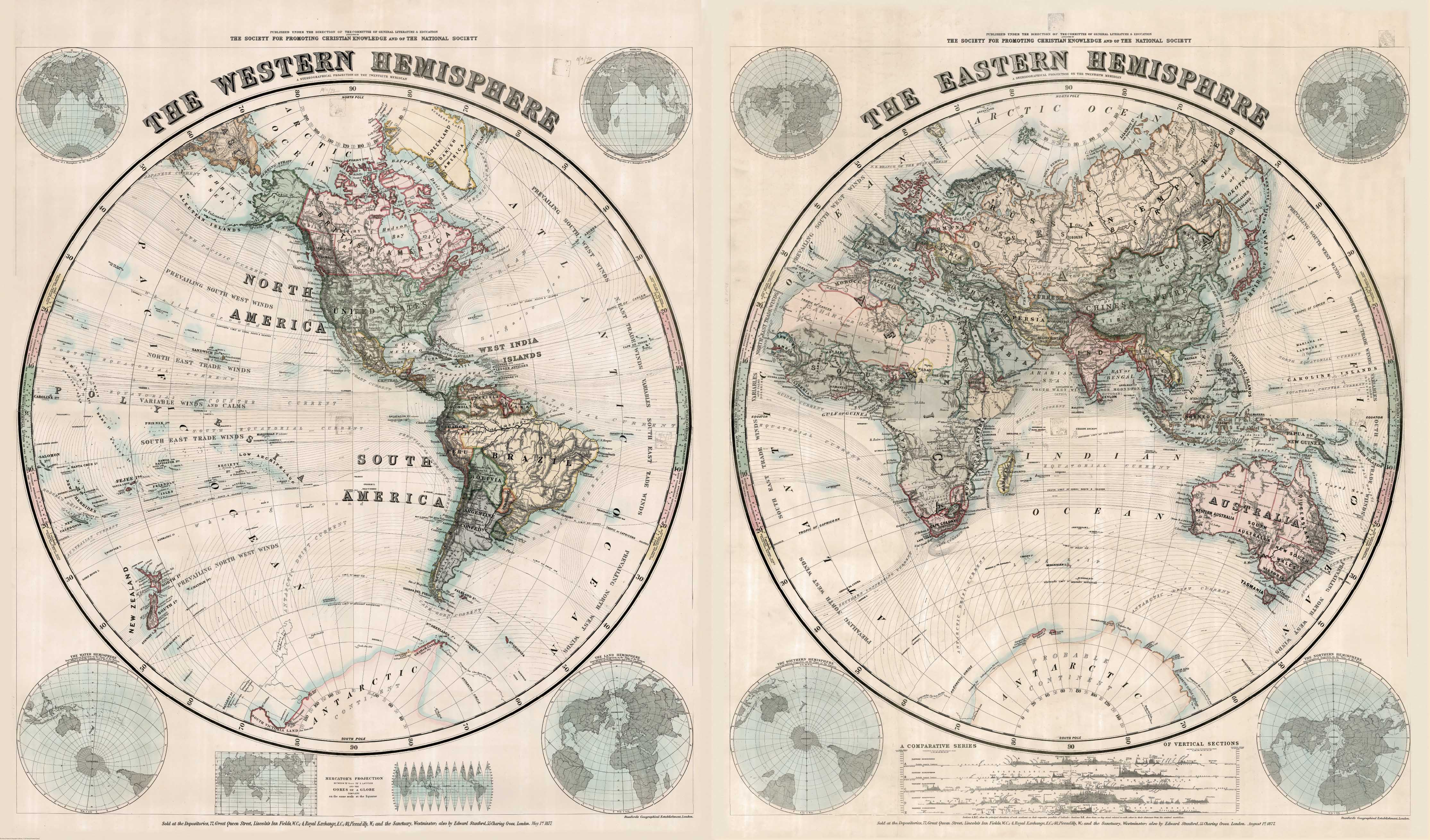
Stanford's Eastern and Western Hemispheres World Map (1877)
$169.95
or make 4 interest-free payments of
$42.49 AUD
fortnightly with
![]() More info
More info
A Grand 19th-Century Dual-Hemisphere Map from the Edward Stanford Cartographic Archive – Reproduced in Stunning Detail
Step back to the Age of Empire, Exploration, and Early Science with this masterful reproduction of Stanford’s Eastern and Western Hemispheres Map, first published in 1877 by Stanford’s Geographical Establishment. Commissioned by the Committee of General Literature and Education, and supported by the Society for Promoting Christian Knowledge and the National Society, this is one of the most visually compelling cartographic pieces of the Victorian era.
Drawn at a time when great swathes of the world were still being charted, this elegant map showcases the world’s two hemispheres in full grandeur. It is an extraordinary blend of geography, science, education, and imperial context—a map made to inspire wonder and learning in equal measure.
🗺️ Historical Cartographic Features
-
Hand-coloured aesthetic: Countries shaded in soft pastel tones, with bold boundary lines in deeper hues typical of 19th-century cartography
-
Western Hemisphere: The Americas are largely complete; Antarctica remains a mystery with scant coastal detail and flat terrain
-
Eastern Hemisphere: Europe is dominated by empires, Africa remains largely unexplored inland, and Asia is broadly recognisable
-
Scientific Insets:
-
Comparative map projections including Mercator, globe gores, and others
-
Polar perspectives and cross-sections showing elevations and latitudinal comparisons across continents
-
-
Ocean currents, trade winds, and tropical zones illustrated with clarity and finesse
-
Latitude and longitude graticules at 10° intervals; hachures used to show relief and mountain ranges
-
A true educational and decorative masterpiece, equal parts history and design
🖨️ Premium Print Options
Choose from three display-ready finishes:
| Format | Description |
|---|---|
| 160gsm Paper | Ideal for framing behind glass – smooth, archival-quality finish |
| Encapsulated Laminate | Sealed in dual 80-micron gloss laminate – durable, wipeable, and perfect for public or educational use |
| 395gsm Canvas | Printed on HP Professional Matte Canvas with pigment-based inks for a fade-resistant, museum-quality reproduction |
🪵 Optional Timber Hang Rails
Laminated & Canvas maps can be ordered with natural timber hang rails affixed top and bottom, lacquered for protection, and fitted with a hanging cord for effortless display.
⏳ Please allow up to 10 working days for delivery of hang-railed maps, as each is professionally hand-finished by our in-house framer.
📐 Available Sizes
| Format | Dimensions (W x H) |
|---|---|
| Standard Size | 2020 mm x 1190 mm |
| Large Format | 2430 mm x 1420 mm |
🧭 Product Details
| Attribute | Details |
|---|---|
| Title | Stanford’s Map of the Eastern and Western Hemispheres |
| Original Publication | 1877, London by Stanford’s Geographical Establishment |
| Collection | Edward Stanford Cartographic Archive |
| Map Type | Dual Hemisphere, Mercator Projection |
| Scientific Insets | Map projections, polar views, elevation sections |
| Finish Options | Paper / Laminated / Canvas with Optional Hang Rails |
| Printed In | Australia |
✅ Why Choose This Map?
| Feature | Benefit |
|---|---|
| Genuine 19th-century historical map | Reproduced with exceptional fidelity from Stanford’s 1877 edition |
| Elegant dual-hemisphere presentation | A true conversation piece and visual anchor for any room |
| Inset scientific diagrams & projections | Perfect for educational or scholarly display |
| Available in large-format canvas | A luxurious addition to libraries, offices, or heritage interiors |
| Versatile mounting options | Choose paper, laminated, or canvas with hang rails |
Whether you're a historian, educator, or collector of antique cartography, this Stanford 1877 Hemispheres Map offers a rare opportunity to own a piece of Victorian world vision—detailed, decorative, and historically resonant.
Frequently Asked Questions
What are the dimensions of the Stanford's Eastern and Western Hemispheres World Map (1877)?
Mapworld wall maps range from standard 700×1000mm to large-format 1000×1430mm Supermaps. The exact dimensions for this map are shown in the product title. Where multiple sizes are available, select your preferred size when adding to cart.
Is this wall map available laminated?
Many Mapworld wall maps are available in paper, laminated, or framed finishes. Check the product options when adding to cart. Laminated maps are wipe-clean and more durable.
Is this the latest edition?
Mapworld stocks the most current editions available from all publishers. Edition year is shown in the product title where applicable. Mapworld updates its catalogue as new editions are released.
Can I write on or pin this wall map?
Laminated wall maps can be written on with whiteboard markers and wiped clean. Paper maps can be pinned on a corkboard. Choose a laminated option for a writeable surface.
Does Mapworld ship the Stanford's Eastern and Western Hemispheres World Map (1877) across Australia?
Yes, Mapworld ships Australia-wide. Standard shipping is a flat $7 rate, with free standard shipping on orders over $75. Express options are available at checkout. Most orders placed before 2pm AEST on weekdays are dispatched same day.
Related Items


© 2026 Mapworld. Website designed by Genie Media
X