- Australia ▾
- Topographic
▾
- Australia AUSTopo 250k (2024)
- Australia 50k Geoscience maps
- Australia 100k Geoscience maps
- Australia 250k Geoscience maps
- Australia 1.1m Geoscience maps
- New Zealand 50k maps
- New Zealand 250k maps
- New South Wales 25k maps
- New South Wales 50k maps
- New South Wales 100k maps
- Queensland 10k maps
- Queensland 25k maps
- Queensland 50k maps
- Queensland 100k maps
- Compasses
- Software
- GPS Systems
- Orienteering
- International ▾
- Wall Maps
▾
- World
- Australia & New Zealand
- Countries, Continents & Regions
- Historical
- Vintage National Geographic
- Australian Capital Territory
- New South Wales
- Northern Territory
- Queensland
- South Australia
- Tasmania
- Victoria
- Western Australia
- Celestial
- Children's
- Mining & Resources
- Wine Maps
- Healthcare
- Postcode Maps
- Electoral Maps
- Nautical ▾
- Flags
▾
- Australian Flag Sets & Banners
- Flag Bunting
- Handwavers
- Australian National Flags
- Aboriginal Flags
- Torres Strait Islander Flags
- International Flags
- Flagpoles & Accessories
- Australian Capital Territory Flags
- New South Wales Flags
- Northern Territory Flags
- Queensland Flags
- South Australia Flags
- Tasmania Flags
- Victoria Flags
- Western Australia Flags
- Gifts ▾
- Globes ▾
Dear valued customer. Please note that our checkout is not supported by old browsers. Please use a recent browser to access all checkout capabilities
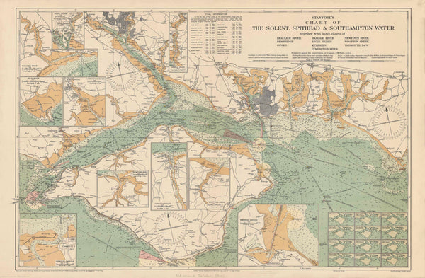
Stanford's Chart of the Solent, Spithead and Southampton Water published 1932
$69.95
or make 4 interest-free payments of
$17.49 AUD
fortnightly with
![]() More info
More info
An Archival Reproduction from the Edward Stanford Cartographic Collection
🗺️ Published: 1932 | Size: 1016 mm (W) x 666 mm (H)
Explore Britain’s Historic Maritime Heartland
This stunning chart is more than a map — it’s a historical snapshot of Britain's southern coast at the height of its maritime influence. Stanford’s Chart of the Solent, Spithead and Southampton Water, first published in 1932, was meticulously prepared under the supervision of Captain O.M. Watts, A.I.N.A. and is based on authoritative British Admiralty sources.
Spanning from Selsey Bill to Milford on Sea, and covering the entire Isle of Wight, this chart is a must-have for:
-
Maritime enthusiasts
-
Historians and naval collectors
-
Decorators seeking classic nautical charm
-
Anyone captivated by Britain's coastal geography
The level of detail and precision reflects the high standards of British hydrographic charting of the early 20th century, making it both a valuable reference tool and a beautiful decorative piece.
🔍 Features & Inset Charts
The chart includes inset plans of 10 key waterways and harbours:
-
Beaulieu River
-
Bembridge
-
Cowes
-
Hamble River
-
River Itchen
-
Keyhaven
-
Lymington River
-
Newtown River
-
Wootton Creek
-
Yarmouth
You'll also find:
-
Soundings at Low Water Ordinary Spring Tides (fathoms on the main chart, feet on the insets)
-
Detailed tidal notations and navigational aids
-
Annotations drawn from official Admiralty charts
-
A refined balance of function and aesthetics, ideal for both use and display
🖨️ Available in Three Premium Formats
📄 160gsm Matte Art Paper
-
Smooth archival-grade paper
-
Perfect for framing under glass
-
Lightweight yet richly printed
💧 Encapsulated Gloss Lamination
-
Sealed in two layers of 80-micron gloss laminate
-
Waterproof, tear-resistant and wipeable
-
Great for hands-on use or high-traffic display areas
-
🪵 Optional timber hang rails available
🖼️ 395gsm HP Matte Canvas
-
Printed on heavy-duty canvas using fade-resistant pigment inks
-
Exceptional detail with a subtle woven texture
-
Durable and long-lasting
-
🪵 Optional timber hang rails available
🪵 Add Timber Hang Rails (Optional)
For a refined finish, we offer hand-fitted timber hang rails for both canvas and laminated maps:
-
Crafted from natural timber with a smooth lacquered finish
-
Top and bottom rails keep the map taut and elegant
-
Fitted hanging cord makes display effortless
-
Elevates the map from practical reference to nautical art
🛠️ Please allow up to 10 working days for hang-railed maps — each one is assembled to order by our specialist framer.
📐 Product Specifications
| Feature | Details |
|---|---|
| Title | Chart of the Solent, Spithead & Southampton Water |
| Original Publisher | Edward Stanford (under Capt. O.M. Watts, A.I.N.A.) |
| Publication Year | 1932 |
| Coverage | Isle of Wight, Selsey to Milford on Sea |
| Insets | 10 detailed river and harbour charts |
| Tidal Information | Yes – soundings in fathoms and feet |
| Scale | Historical nautical scale (varies by inset) |
| Size | 1016 mm (W) x 666 mm (H) |
| Material Options | 160gsm Paper, Laminated, or 395gsm Canvas |
| Printing | High-resolution with pigment-based archival inks |
| Hang Rail Option | Available for laminated and canvas formats |
| Printed In | Australia |
🎯 Perfect For:
-
⚓ Sailing clubs, coastal lodges, and heritage displays
-
📚 Collectors of naval or Edwardian ephemera
-
🏠 Elegant home, library or study decor
-
🎁 An exceptional gift for historians and seafarers
📦 How to Order
-
Choose your material: Paper, Laminated, or Canvas
-
Select hang rails if desired (recommended for instant display)
-
Add to cart and proceed to checkout
-
Enjoy your historic reproduction delivered with care
📦 Rolled maps ship securely in heavy-duty packaging
🪵 Framed/hang-railed versions are made to order – please allow extra time
✨ A Tribute to Britain’s Coastal Legacy
Whether you’ve sailed the Solent or simply admire maritime history, this beautiful chart is a timeless tribute to one of England’s most iconic waterways. Display it with pride — in your home, office, or aboard your next voyage.


